Charles A. Reeves, Jr.
IntroductionMany of us who have done genealogical
research quickly became familiar with what most call "topo
maps." These are maps the U.S. Geological Survey (USGS)
first started publishing in 1884. The goal was to
create a series of maps of the entire United States based on
a grid defined by the latitude-longitude (Lat/Long)
coordinate system used for many, many years to pinpoint
locations on the earth. Since the advent of the Global
Positioning System (GPS) satellites, most folks now call
these GPS coordinates. Following is information on what maps
are available, how to obtain and use them, and how to use
the associated USGS Geographic Names Information System
(GNIS).
The maps became useful in genealogical research because of the amount of information they contained. The USGS formerly listed approximately 65 different kinds of things shown on the maps, which they call "Feature Class." These include: Airport, Bend, Bridge, Building, Canal, Cave, Cemetery, Church, Dam, Falls, Forest, Gap, Harbor, Hospital, Island, Lake, Locales, Military, Mine, Populated Place, Post Office, Range, Ridge, School, Spring, Stream, Summit, Swamp, Tower, Trail, Tunnel, and Valley, just to name a few. These names will be important when I discuss GNIS below, although as will be mentioned, most of the features of use to genealogical research are no longer shown on the latest topo maps, nor are they listed in GNIS. But as also noted, that GNIS data is still available, at least for Tennessee. The USGS has scanned every map they ever produced, and digital copies are available for download on-line, as well as new versions as they are produced.
A note about Soil Maps: I see these old maps come up on eBay all the time. I don't doubt they might be useful for some, but not for those doing genealogical research. They show very little detail.
The maps became useful in genealogical research because of the amount of information they contained. The USGS formerly listed approximately 65 different kinds of things shown on the maps, which they call "Feature Class." These include: Airport, Bend, Bridge, Building, Canal, Cave, Cemetery, Church, Dam, Falls, Forest, Gap, Harbor, Hospital, Island, Lake, Locales, Military, Mine, Populated Place, Post Office, Range, Ridge, School, Spring, Stream, Summit, Swamp, Tower, Trail, Tunnel, and Valley, just to name a few. These names will be important when I discuss GNIS below, although as will be mentioned, most of the features of use to genealogical research are no longer shown on the latest topo maps, nor are they listed in GNIS. But as also noted, that GNIS data is still available, at least for Tennessee. The USGS has scanned every map they ever produced, and digital copies are available for download on-line, as well as new versions as they are produced.
Some may be wondering why, in this
era of instant gratification, one would ever be interested
in topo maps when most of us carry a phone or tablet where
maps can be easily viewed. Those maps certainly have their
place, and can show a substantial amount of information,
but they sometimes don't contain the historical
information needed in genealogical research.
A note about Soil Maps: I see these old maps come up on eBay all the time. I don't doubt they might be useful for some, but not for those doing genealogical research. They show very little detail.
The Early Maps
As stated, the USGS
started publishing topo maps in 1884. This lasted until
around the 1920s or 30s, when this project was terminated
without being finished; some (perhaps many) of the planned
maps were never completed. These early maps covered
30 degrees of Latitude and Longitude.* They are sometimes
called by their scale, 1:125,000, meaning that one foot on
the map represents 125,000 feet on the ground. They
typically cover approximately 28 miles east-west
(longitude) and 38 miles north-south (latitude).
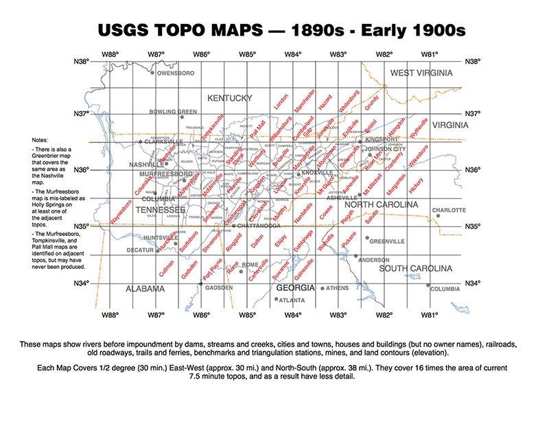
I've never found an index showing what early maps the USGS actually published, but I believe I have determined those that exist for East Tennessee. These are shown in the figure below. A PDF version is also available. More later on how to obtain copies of these maps, where the names of the maps will be needed.
*Latitude and
Longitude are measured in degrees, minutes and seconds,
and just like time measurement, there are 60 seconds in
a minute and 60 minutes in a degree. Latitude and
Longitude are also frequently displayed as decimal
degrees; e.g., 60.123456 (it can take a lot of decimal
places to achieve the accuracy needed to locate
something). Regardless, there is a connection between
Lat/Long and time which we won't delve into here. For
those interested, Dava Sobel wrote a really good book,
since made into a TV movie, "Longitude," about the quest
for a timepiece good enough to establish Longitude with
enough precision so that voyagers, primarily those
navigating sailing ships, would know where they were.
I've never found an index showing what early maps the USGS actually published, but I believe I have determined those that exist for East Tennessee. These are shown in the figure below. A PDF version is also available. More later on how to obtain copies of these maps, where the names of the maps will be needed.