Welcome Friend
Your Host is Charles A. Reeves, Jr.
Tennessee Maps

The Maps of Charles A. Reeves, Jr.
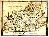
Modern Map of Tennessee
Showing county lines only.
Also see Charles’ Introduction Page
Includes the Three Grand Divisions of Tennessee
Two 1895 Topo Maps
Grundy and Marion Counties. Very large PDF file, 3.36 Megs.
Warren County. Very large PDF file, 1.55 Megs.
These two PDF images were created by Ralph Thompson from public domain maps. The two PDF images are copyrighted by Mr. Thompson. He contributed them to TNGenWeb Project for noncommercial use only. We thank him for his kind contribution.
USGS Topo Maps
An introduction to these maps, their history, and how to obtain copies, along with an introduction to the GNIS.
Early Maps Showing the State of Franklin
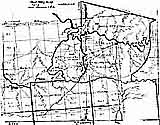
Tennessee County Formation Maps
Early Tennessee Detail Maps Extracted from Mathew Carey’s Atlas Map. (90k page)
Early Maps of Tennessee
Links to images of maps issued showing the state from around 1784 to 1889
Early County Property Owners Maps
Links to images for: Bedford (1878), Davidson (1871), Knox (1895), Gibson (1877), Giles (1878), Haywood (1878), Madison (1877), Marshall (1899), Maury (1878), Montgomery (1877), Rutherford (1878), Shelby (1888), Sumner (1878) & Williamson (1878)
Census Maps of Tennessee
Tennessee, 1834
Extracted from Henry Schenck Tanner’s U. S. Map. (960k). Save this on a disk or your hard drive. This wonderful map is worth the down load wait.
New River Area, 1834
The Junction of NC, TN, & VA. Extracted from Henry Schenck Tanner’s U. S. Map. (337k)
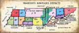
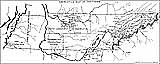
Tennessee’s Surveyors’ Districts.
A modern map and paper on an obscure but important subject.
2nd Surveyors’ District
Southern Middle Tennessee (64k)
3rd Surveyors’ District
Eastern Middle Tennessee. (72k)
District South of the French Broad and Holston
An East Tennessee Surveyors’ District
12th and 13th Surveyors’ Districts, 1832
Northern West Tennessee. (246k)
Blast Furnaces in North-western Middle Tennessee
Undated, but ca 1880-1900. (56k)
Bell & James Counties
Two detail sections from an 1877 map, published by S. Augustus Mitchell. The first map shows Bell County in southwest Tennessee. Bell is one of Tennessee’s Lost Counties. Bell County never existed. Note that Memphis is located to the west. The other map shows James County in southeast Tennessee. James was erected in 1871 and was dissolved in 1920. It was located east of Chattanooga.
Also see James County Tennessee Civil Districts
Giles County Tennessee, Madison County - Territory of Mississippi - 1805-1817
A Modern Map
Tennessee’s Land Forms
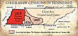
Chickasaw Cessions In Tennessee.
A Paper and a Map
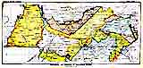
Indian Land Cessions in Tennessee
Goodspeed’s 1886 Aboriginal Map of Tennessee
Maury County Tennessee, 1851
(150k page)
Civil Districts
Bedford County 1836 (Modern Graphic)
(45k graphic.)
Bedford County 1836 (Original)
(275k graphic.)
James County 1919 (Modern Graphic)
(11k graphic.)
Tennessee & Beyond
Stands Along the Natchez Trace
(140k page)
Thomas Bradford 1835 Atlas.
Maps of:
Tennessee and Kentucky
Louisiana and part of Arkansas
Mississippi and Alabama
North & South Carolina and Georgia
Pennsylvania and New Jersey
Virginia, Maryland, and Delaware
Linguistic Stocks of American Indians
A detail map of the South-eastern United States, ca1890. (260k)
American Indian Tribes, Cultural Areas, and Linguistic Stocks
A detail map of the South-eastern United States. Compiled 1966. (260k)
Independent Texas
As shown on a little 1845 French map of North America that shows the U. S. southwest as 100% “Mexique” (Mexico). The hand coloring may be modern. (181k) Detail of Texas area only. (49k)
United States, 1832
From an old Scottish map. (183k)
Tanner’s Arkansas Territory 1832
Territory of Mississippi - 1798-1817
Georgia & the American South, 1748 & 1752
A Modern Map
Grants of the Georgia Western Territory
An Old Time Map
The Three Counties of the Eastern Part of the Territory of Mississippi, 1809
A Modern Map
Overhill Cherokee Towns - 1762
Henry Timberlake’s Map From His Book. (120k)
Headwaters of the Clinch and Holston - 1774
South West Virginia (93k)
International Maps
Germany, 1871-1918
This modern map was made for our Tennesseans in World War I Project. (72k)
A Few Words About Old Maps
Our maps are from old atlases. The customary practice in the map trade is to remove the maps from the atlases. The folks that do this are called “Breakers” or occasionally “Rippers.” Often the old atlases are in terrible condition by the time the Breaker receives them. Original, individually sold, antique maps are more rare and usually command a much higher price than those maps removed from an atlas.Many original maps were hand colored. It is a common practice today to color old originally un-colored maps. Only if one of our maps has modern coloring, will we so note. If we do not so note, consider the coloring to be original.
Early county maps are as scarce as hen’s teeth. During the Civil War, both sides found that the lack of good maps was a major hindrance. The Official Military Atlas of the Civil War is available in re-print. Tennessee is not well represented in that atlas.
TNGenWeb Home PageThis page last updated on
© 1997-present