


~ Indian Peace Medal ~
Graphic Courtesy
American Numismatic Society
Your host “Wild Bill” Oliver (wnoliver@sbcglobal.net)
Search Engine
Search This Site, First People of Tennessee, & The Intruders
Also! Please Visit
Indian Land Cessions

Colonial Period Indian Land Cessions in the American Southeast
Cherokee Land Cessions
Charles C. Royce’s 1884 Cherokee Map with Cessions and Original Territorial Limits
Old Cherokee Town Names
The Chickasaw and Their Cessions
First People of Tennessee, TNGenWeb Project.
Text and Maps.
|
First, choose a map (below), then find the number on
the map of the area that interests you, then match that number in the Treaty List below.
Each map has mulitple numbers that correspond with the numbers in the list below.
There are no maps
in this series for Maryland, Kentucky, South Carolina, or Virginia. One Chickasaw
cession includes part of Kentucky and
is shown on a Tennessee map.
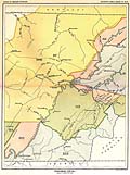
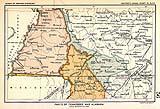
You will need to use your “Back” button to return here from the Large maps. Because the maps are larger than your screen, you will need to use the slide controls at the side and bottom of the frame to move the maps. The maps are from the original book Indian Land Cessions in the United States, Compiled by Charles C. Royce. It was published in The 18th Annual Report of the Bureau of American Ethnology -- 1896-’97, Vol II, Smithsonian Institution, printed by the Government Printing Office, 1899. The cession (treaty) text is from Indian Affairs: Laws and Treaties. Vol. II (Treaties), Compiled and edited by Charles J. Kappler, Washington : Government Printing Office, 1904. Both books are from the collection of Fred Smoot. Neither of the books contain pre-federal treaty cessions, such as Henderson’s Purchase (Transylvania Land Company). For a history of pre-federal treaties, see our Colonial Period Indian Land Cessions In Tennessee page. Also included in our list of treaties are selected historical documents that pertain to the treaties and are placed in chronological order along with those treaties. NOTE: The cession numbers found on the Royce maps are matched to text entries also found in his book. This gives us the date, place, nation, etc., of the cession. The cession information is then matched to a treaty from Kappler’s book. Additional southern area treaties (generally not involving land cessions) which are not found on the Royce maps, are included in chronological order (below) and are linked as such: (***). Tennessee Maps
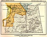
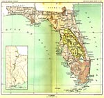
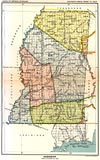
American Southeast Maps Alabama
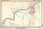
South Carolina Tennessee Treaty Map, No.54 Showing part of South Carolina 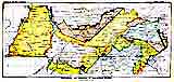 Click here for the LARGE (694k) version. Treaty List The numbers on the maps match the numbers below.  3. Cherokee, Treaty of Hopewell, 28 Nov 1785
(Tennessee, Kentucky and North Carolina) (***). Choctaw, Treaty of Hopewell, 3 Jan 1786. (***). Chickasaw, Treaty of Hopewell, 10 Jan 1786
(Chickasaw Boundaries Defined) 7. Creek, 7 Aug 1790 (Georgia) 8. Cherokee, Treaty of Holston, 2 Jul 1791
(Tennessee) (***). Cherokee, 26 Jun 1794. (Treaty of Holston
binding. Cherokee Boundaries to be Marked, etc.) Act of Congress. An
Act to Regulate Trade and Intercourse with the Indian Tribes, and to Preserve Peace on the Frontiers,
19 May 1796. (***). Creek, 29 Jun 1796 42. Cherokee, Treaty of Tellico, 2 Oct 1798
(Tennessee and North Carolina) 3. Cherokee, Treaty of Hopewell, 28 Nov 1785
(Tennessee, Kentucky and North Carolina) (***). Choctaw, Treaty of Hopewell, 3 Jan 1786. (***). Chickasaw, Treaty of Hopewell, 10 Jan 1786
(Chickasaw Boundaries Defined) 7. Creek, 7 Aug 1790 (Georgia) 8. Cherokee, Treaty of Holston, 2 Jul 1791
(Tennessee) (***). Cherokee, 26 Jun 1794. (Treaty of Holston
binding. Cherokee Boundaries to be Marked, etc.) Act of Congress. An
Act to Regulate Trade and Intercourse with the Indian Tribes, and to Preserve Peace on the Frontiers,
19 May 1796. (***). Creek, 29 Jun 1796 42. Cherokee, Treaty of Tellico, 2 Oct 1798
(Tennessee and North Carolina) 43. Choctaw, 17 Dec 1801 (Mississippi) (***). Chickasaw, 24 Oct 1801 (Roads) 44. Creek, 16 Jun 1802 (Georgia) 46. Choctaw, 17 Oct 1802 (Alabama, Mississippi) 52. Cherokee, 24 Oct 1804. (Georgia - Wafford’s Settlement) 55. Chickasaw, 23 Jul 1805 (Tennessee and Kentucky. Not shown on the
map is the Chickasaw cession of land in Middle Tennessee.) 57. Cherokee, 25 Oct 1805 (Tennessee and Kentucky) 58-59. Cherokee, 27 Oct 1805 (Cessions near
South West Point Tennessee) 58. Cherokee, 27 Oct 1805 (Tennessee) 59. Cherokee, 27 Oct 1805 (Tennessee) 60. Creek, 14 Nov 1805 (Georgia) 61. Choctaw, 16 Nov 1805 (Alabama, Mississippi) 64. Cherokee, 7 Jan 1806 (Alabama and Tennessee) 64. Cherokee, 7 Jan 1806 64. Cherokee, 11 Sep 1807 (Elucidation of a convention with the Cherokee Nation) A Letter. How the Cherokee Lost the Elk River, 1807 75. Creek, 9 Aug 1814 (Georgia, Alabama) (This Treaty was the result of the Red Sticks War.) 76. Cherokee, 22 Mar 1816 (Georgia, North and South
Carolina) (***). Cherokee , 22 Mar 1816 (***). Cherokee, 14 Sep 1816 79-81. Chickasaw, 20 Sep 1816 79. Chickasaw, 20 Sep 1816 (Tennessee,
Alabama and Mississippi.
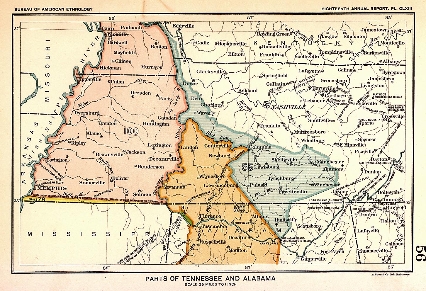
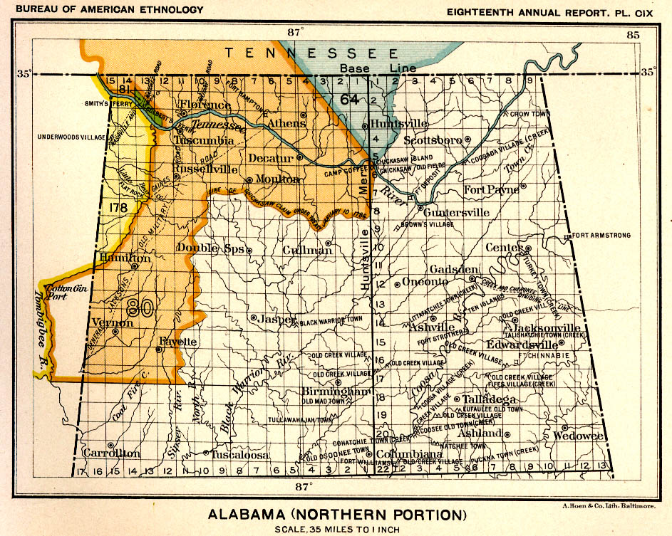
See Map No. 56) 80. Chickasaw, 20 Sep 1816 (this number is found only on Map No. 56)
(Tennessee, Alabama, and Mississippi ) 81. Chickasaw, 20 Sep 1816 (this number is found only on Map No. 56)
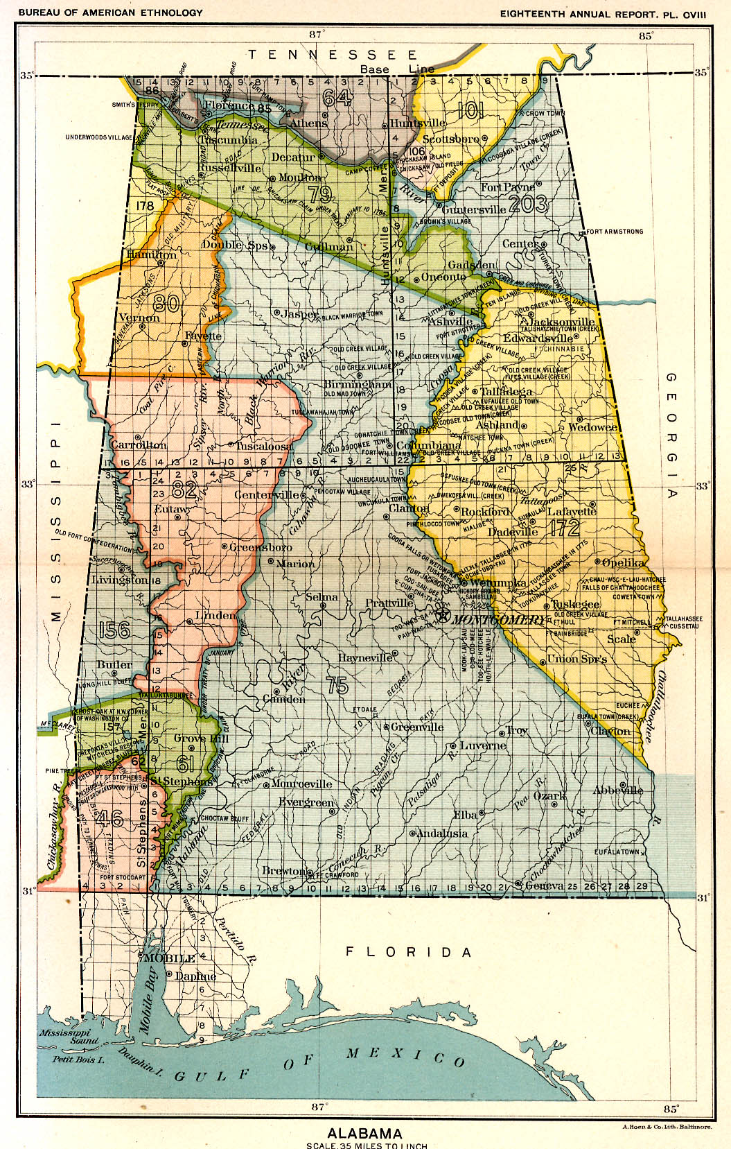
(Alabama) 82. Choctaw, 24 Oct 1816 (Alabama, Mississippi) 83-86. Cherokee, 8 Jul 1817 83. Cherokee, 8 Jul 1817 (Georgia) 84. Cherokee, 8 Jul 1817 (Tennessee) 85. Cherokee, 8 Jul 1817 (Alabama) 86. Cherokee, 8 Jul 1817 (Alabama) 92. Creek, 22 Jan 1818 (Georgia) 93. Creek, 22 Jan 1818 (Georgia) 100. Chickasaw, 19 Oct 1818, The Great Chickasaw
Cession.
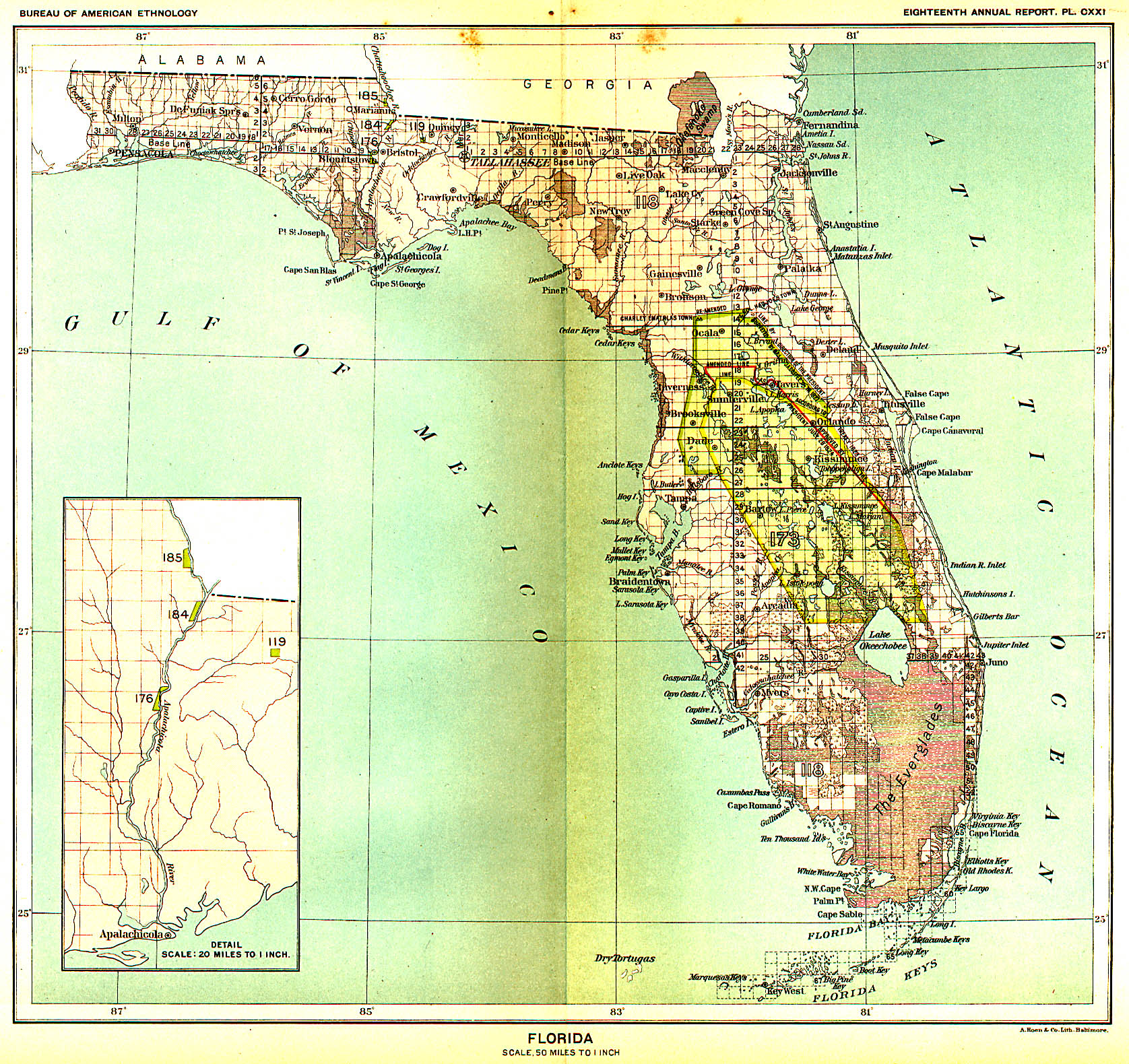
(Tennessee and Kentucky) 101-109. Cherokee, 27 Feb 1819 101. Cherokee, 27 Feb 1819 (Tennessee and Alabama) 102. Cherokee, 27 Feb 1819 (Tennessee) 103. Cherokee, 27 Feb 1819 (Tennessee, North and South Carolina) 104. Cherokee, 27 Feb 1819 (Tennessee) 105. Cherokee, 27 Feb 1819 (Tennessee) 106. Cherokee, 27 Feb 1819 (Alabama) 107. Cherokee, 27 Feb 1819 (Tennessee) 108. Cherokee, 27 Feb 1819 (Tennessee) 109. Cherokee, 27 Feb 1819 (Tennessee) 115. Choctaw, 18 Oct 1820 (Mississippi) 116. Creek, 8 Jan 1821 (Georgia) (***). Creek, 8 Jan 1821 (Claims) 118., 119. Florida tribes 18 Sep 1823 (Florida) 118. Florida tribes 18 Sep 1823 (Florida) 119. Florida tribes 18 Sep 1823 (Florida) (***). Choctaw, 20 Jan 1825 (***). Creek, 12 Feb 1825 (***). Creek, 29 Jun 1825, (Agreement with the Creeks, Appendix) 127. Creek, 24 Jan 1826 (Georgia) 131. Creek, 24 Jan 1826 (Georgia)
Extracts From President Andrew Jackson’s Addresses to Congress, 1829-1836. Act of Congress. Indian Removal Act, 28 May 1830. Petiton to the U.S. Supreme Court. Cherokee Nation vs. State of
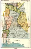
Georgia 1830-1831. (***). Chickasaw, 31 Aug 1830. (Unratified) 156, 157. Choctaw, 27, 27 Sep 1830 (Alabama, Mississippi) (Choctaw cede of all lands east of Mississippi River) 172. Creek, 24 Mar 1832 (Alabama) (Creeks cede of all lands east of Mississippi River) 173. Seminole, 9 May 1832 (Florida) (Seminole cede all lands in Florida) 176. Appalachicola Band, 11 Oct 1832 (Florida) 178. Chickasaw, 20 Oct 1832 (Tennessee, Alabama,
and Mississippi.
The map shows only the tract of land between the Winchester
Line and the re-surveyed state line. In reality, with this Treaty,
the Chickasaw ceded all of their lands east of the Mississippi
River. Please see Mississippi Map No. 36 for better look at cession area No. 178. 456k.) (***). Chickasaw, 22 Oct 1832. (Supplement to 20 Oct 1832 Treaty) (***). Seminole, 28 Mar 1833. 184., 185. Appalachicola Band, 18 Jun 1833 (Florida) 185. Appalachicola Band, 18 Jun 1833 (Florida) 185. Certain Chiefs in Florida 18 Jun 1833 (Florida) (***). Chickasaw, 24 May 1834. (Technical provisions regarding removal, etc.) (***). Cherokee, 14 Mar 1835. (Unratified) 203. Cherokee, 29 Dec 1835, Treaty of Removal
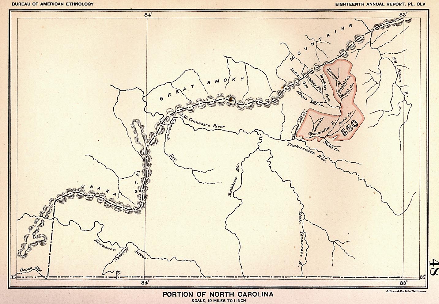
or Treaty of New Echota, the so called Trail of Tears Treaty. Tennessee, Alabama and Georgia) Gen. Wool’s Prolamation to the Cherokee. 22 March 1837. Gen. Scott’s Prolamation to the Cherokee. 10 May 1838. Cherokee Removal Order. 17 May 1838. 580. Eastern Band of Cherokee, 3 Mar 1875 (North Carolina) (Funds to be
expended in perfecting Cherokees’ title to their lands in North Carolina.
By an Act of Congress) 43. Choctaw, 17 Dec 1801 (Mississippi) (***). Chickasaw, 24 Oct 1801 (Roads) 44. Creek, 16 Jun 1802 (Georgia) 46. Choctaw, 17 Oct 1802 (Alabama, Mississippi) 52. Cherokee, 24 Oct 1804. (Georgia - Wafford’s Settlement) 55. Chickasaw, 23 Jul 1805 (Tennessee and Kentucky. Not shown on the
map is the Chickasaw cession of land in Middle Tennessee.) 57. Cherokee, 25 Oct 1805 (Tennessee and Kentucky) 58-59. Cherokee, 27 Oct 1805 (Cessions near
South West Point Tennessee) 58. Cherokee, 27 Oct 1805 (Tennessee) 59. Cherokee, 27 Oct 1805 (Tennessee) 60. Creek, 14 Nov 1805 (Georgia) 61. Choctaw, 16 Nov 1805 (Alabama, Mississippi) 64. Cherokee, 7 Jan 1806 (Alabama and Tennessee) 64. Cherokee, 7 Jan 1806 64. Cherokee, 11 Sep 1807 (Elucidation of a convention with the Cherokee Nation) A Letter. How the Cherokee Lost the Elk River, 1807 75. Creek, 9 Aug 1814 (Georgia, Alabama) (This Treaty was the result of the Red Sticks War.) 76. Cherokee, 22 Mar 1816 (Georgia, North and South
Carolina) (***). Cherokee , 22 Mar 1816 (***). Cherokee, 14 Sep 1816 79-81. Chickasaw, 20 Sep 1816 79. Chickasaw, 20 Sep 1816 (Tennessee,
Alabama and Mississippi.
See Map No. 56) 80. Chickasaw, 20 Sep 1816 (this number is found only on Map No. 56)
(Tennessee, Alabama, and Mississippi ) 81. Chickasaw, 20 Sep 1816 (this number is found only on Map No. 56)
(Alabama) 82. Choctaw, 24 Oct 1816 (Alabama, Mississippi) 83-86. Cherokee, 8 Jul 1817 83. Cherokee, 8 Jul 1817 (Georgia) 84. Cherokee, 8 Jul 1817 (Tennessee) 85. Cherokee, 8 Jul 1817 (Alabama) 86. Cherokee, 8 Jul 1817 (Alabama) 92. Creek, 22 Jan 1818 (Georgia) 93. Creek, 22 Jan 1818 (Georgia) 100. Chickasaw, 19 Oct 1818, The Great Chickasaw
Cession.
(Tennessee and Kentucky) 101-109. Cherokee, 27 Feb 1819 101. Cherokee, 27 Feb 1819 (Tennessee and Alabama) 102. Cherokee, 27 Feb 1819 (Tennessee) 103. Cherokee, 27 Feb 1819 (Tennessee, North and South Carolina) 104. Cherokee, 27 Feb 1819 (Tennessee) 105. Cherokee, 27 Feb 1819 (Tennessee) 106. Cherokee, 27 Feb 1819 (Alabama) 107. Cherokee, 27 Feb 1819 (Tennessee) 108. Cherokee, 27 Feb 1819 (Tennessee) 109. Cherokee, 27 Feb 1819 (Tennessee) 115. Choctaw, 18 Oct 1820 (Mississippi) 116. Creek, 8 Jan 1821 (Georgia) (***). Creek, 8 Jan 1821 (Claims) 118., 119. Florida tribes 18 Sep 1823 (Florida) 118. Florida tribes 18 Sep 1823 (Florida) 119. Florida tribes 18 Sep 1823 (Florida) (***). Choctaw, 20 Jan 1825 (***). Creek, 12 Feb 1825 (***). Creek, 29 Jun 1825, (Agreement with the Creeks, Appendix) 127. Creek, 24 Jan 1826 (Georgia) 131. Creek, 24 Jan 1826 (Georgia)
Extracts From President Andrew Jackson’s Addresses to Congress, 1829-1836. Act of Congress. Indian Removal Act, 28 May 1830. Petiton to the U.S. Supreme Court. Cherokee Nation vs. State of
Georgia 1830-1831. (***). Chickasaw, 31 Aug 1830. (Unratified) 156, 157. Choctaw, 27, 27 Sep 1830 (Alabama, Mississippi) (Choctaw cede of all lands east of Mississippi River) 172. Creek, 24 Mar 1832 (Alabama) (Creeks cede of all lands east of Mississippi River) 173. Seminole, 9 May 1832 (Florida) (Seminole cede all lands in Florida) 176. Appalachicola Band, 11 Oct 1832 (Florida) 178. Chickasaw, 20 Oct 1832 (Tennessee, Alabama,
and Mississippi.
The map shows only the tract of land between the Winchester
Line and the re-surveyed state line. In reality, with this Treaty,
the Chickasaw ceded all of their lands east of the Mississippi
River. Please see Mississippi Map No. 36 for better look at cession area No. 178. 456k.) (***). Chickasaw, 22 Oct 1832. (Supplement to 20 Oct 1832 Treaty) (***). Seminole, 28 Mar 1833. 184., 185. Appalachicola Band, 18 Jun 1833 (Florida) 185. Appalachicola Band, 18 Jun 1833 (Florida) 185. Certain Chiefs in Florida 18 Jun 1833 (Florida) (***). Chickasaw, 24 May 1834. (Technical provisions regarding removal, etc.) (***). Cherokee, 14 Mar 1835. (Unratified) 203. Cherokee, 29 Dec 1835, Treaty of Removal
or Treaty of New Echota, the so called Trail of Tears Treaty. Tennessee, Alabama and Georgia) Gen. Wool’s Prolamation to the Cherokee. 22 March 1837. Gen. Scott’s Prolamation to the Cherokee. 10 May 1838. Cherokee Removal Order. 17 May 1838. 580. Eastern Band of Cherokee, 3 Mar 1875 (North Carolina) (Funds to be
expended in perfecting Cherokees’ title to their lands in North Carolina.
By an Act of Congress) |

|
Related TNGenWeb Project Links
First People of Tennessee
The Intruders
Tennessee Land
Tennessee Maps
Useful Indian Treaty Links
Complete Text of Kappler’s Books
At Oklahoma State University
Complete Set (67) of Royces’ Indian Cessions Maps
At U.S. Digital Map Library, Indian Land Cessions.
Maps are in Low Resoluton JPG Format, Each Savable on a Floppy Disk.
Complete Set (67) of Royces’ Indian Cessions Maps
Plus Text From Royces’ Book, etc.
Indian Land Cessions in the United States
A Century of Lawmaking, American Memory, Library of Congress.
Maps are in High Resolution “Mr.Sid” (.sid) Format.
Chickasaw Historical Research Page
Kerry Armstrong’s Outstanding
Chickasaw Website.
TNGenWeb Project Main Page