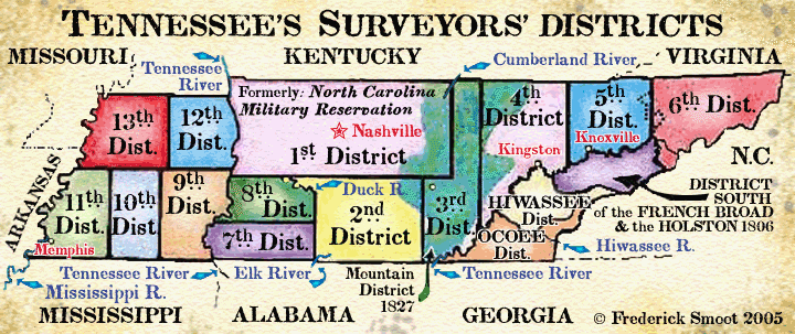
To our knowledge, there is no extant original map of the overall system of
Tennessee’s various early Surveyors’ Districts. Modern
maps that show inaccurate boundary line location of those districts have been created
and published. This paper is an attempt to document the real boundaries of those
districts. To understand the bounds of the districts, we need to turn to
Whitney’s Land Law of Tennessee,
1
and other reliable sources including some extant district maps.
“... the United States, in Congress assembled, on the eighteenth day of
April, in the year of our Lord one thousand eight hundred and six, passed an act
entitled ‘An act to authorize the State of Tennessee to issue grants and perfect
titles to certain lands therein described, and to settle claims to the vacant and
unappropriated lands within the same,
’...”2
Then that very year, the Tennessee State Assembly established the
first seven of her Surveyors’ Districts. Two land offices or Register’s
Offices were established, one in Nashville, West [now called Middle]
Tennessee and one in East Tennessee. The East Tennessee land office was probably
located at Knoxville. In 1825, a third land office or Register’s Office for
Western Tennessee was established in Jackson, Madison County. In 1827, the Mountain
District was added, complete with a Register’s Office. It is not clear if this
new office had the same status as the three earlier land offices. Each District
had a surveyor’s office and an entry-taker’s office, sometimes in the same
building, possibly the same room. Occasionally, when a district was new, or in some
instances when a district was old and running out of business, its office might be
run from a private home. From the first seven districts formed in 1806, the number
grew to seventeen by 1836. Some of the original district offices had been closed by
1836. Thirteen were numbered, four were named.
The districts were legal entities, answerable only to the State. Generally, their
boundaries were not adjusted to the ever changing county lines.
However, there were two exceptions, at least. In 1807, the line between the 5
th and 6
th Districts was altered to conform to certain
county lines.3
[See 5th District].
The 1827 Mountain District was formed from parts of four districts, the 3
rd District being the major contributor.
Here many county lines were followed. From time to time, many offices, including the
register’s, surveyors’, and entry-taker’s,
4
were moved or closed. From the 1820’s on, we find the closing of some district
land offices, their duties being shifted to various counties. Constant change was the
rule.
Prior to 1806, all lands that had been granted in what was to be come Tennessee, had
been surveyed with the “metes and bounds” system.
That is to say, a system where a tract might be connected to a neighbor’s tract
or the meanders of a creek or the spur of a mountain but not connected to surveyed
system of predetermined section and range lines and townships.
After ten years of negotiations with the Federal Government and North Carolina,
Tennessee was finally able, in 1806, to establish her Surveyors’ Districts, and
organize a system of survey, similar to that used by the Federal Government in Ohio
[Northwest Territory].
The section and range lines in the area east and north of the Congressional
Reservation were to be to surveyed six miles apart so as to create sections or
townships that were six miles square.
The 1806 Act of Congress required the use of six mile squares and within each square,
640 acres were to be set aside for the use of the schools. As far as we can tell, the
1st , 2nd
and 3rd Districts ran their lines true to the
meridian. Both the 6th and the Hiwassee
Districts maps confirm that the range lines ran northerly and were probably true.
In the Ocoee District, by law the lines were run to a base line, south 20 degrees west.
or as we might say, roughly true to the Tennessee River. We have not yet been able to
prove that the 4th District and the District
south of the French Broad and Holston were surveyed with section and range lines as
directed by the State Assembly.
5
However, as it was a legal requirement to do so, it is probable that all districts
were surveyed with section and range lines, except the 1827 Mountain District.
The sections and range lines in the area that had been the Congressional Reservation
were to be surveyed five miles apart so as to create sections or townships that were
five miles square. This five mile square does not conform to the 1806 Act of Congress
where the six mile square was established. The 7
th and 8th
Districts ran their lines true to the meridian.
6 The 9
th through the 13th
Districts seem to have run their lines slightly to the north east
by about 3.5 degrees. This anomaly may have been caused by the original District
Surveyors using the then current inaccurate Tennessee-Mississippi State boundary line
for their reference. That old State line, referred to as the Winchester line, was off
by about 3.5 degrees to the northwest. The 1865 Johnson’s Kentucky and
Tennessee Map,
7
shows the section and range lines without numbers for Districts 9 through 13 and the
Hiwassee and Ocoee Districts.
Ultimately, the district survey system failed. By 1850, most, if not all surveys were
done with the “metes and bounds” system. The closing of Tennessee’s
Land Office system occurred in 1903. Its records were sent to the Secretary of State
in Nashville and then transferring to the State Archives. We would be hard pressed
today to find a county official that even knew of the existence of the former
Surveyors’ Districts and how the districts worked.
Yet, the Surveyors’ Districts are of importance to historians, land researchers,
environmental researchers and genealogists simply because of the very large, but
unfortunately incomplete, collection of the Surveyors’ Districts records that are
available.8
These records may contain early land records that precede
existing county records. These records should be used in conjunction with the separate
county records and land grant records. Because of importance of these records, a
short history of the different relevant material follows.
The Walker Line
Conflict
An early imperfect Tennessee-Kentucky State Line
survey taken in 1779, caused the Walker Line Conflict. This, in turn, caused many
problems regarding land surveys along that State Line in both East and Middle
Tennessee. Some individual tracts in Districts 1 through 6 and near that State Line
that ought to be recorded in the Surveyors’ Districts records may be recorded in
Kentucky records.
9
The U. S. Congressional Reservation
In 1806, the Congress of the United States created U. S. Congressional Reservation as
Indian land. Non-Indian settlement on the reservation was forbidden . “Beginning
at the place where the eastern or main branch of Elk River shall intersect the
[southern] boundary line of the State of Tennessee; from thence running due
north, until said line shall intersect the northern or main branch of Duck River;
thence down the waters of Duck River, to the military boundary line, as established
by the seventh section of an act of the State of North Carolina...thence with the
military boundary line, west, to a place where it intersects the Tennessee River;
thence down the waters of the Tennessee, to a place where the same intersects the
northern boundary line of the State of Tennessee.”
10
From this land, Districts 7 through 13 were formed in 1819.
The 1806 West { Middle }
Tennessee Districts.
The
1st District, formerly the North
Carolina Military Reservation
Located in north Middle Tennessee. The 1
st District enjoyed the exact same metes
and bounds as the old North Carolina Military Reservation. This district “...to
be bound by the lines described in the seventh section of an act of North Carolina,
passed on the seventeenth day of May, in the year one thousand seven hundred and
eighty three, entitled, ‘An act to amend an act, entitled, an act for the relief
of the officers and soldiers in the continental line, ’-- which shall compose a
district, and shall be known and distinguished by the name of the First District.
”11
The Military Reservation lines were: “...beginning on the Virginia [now
Kentucky] line, where the Cumberland River intersects the same; thence south
fifty-five miles; thence west, to the Tennessee River; thence down the Tennessee to
the Virginia [Kentucky] line; thence with the said Virginia [Kentucky] line
east, to the beginning. ”
12, 13
Certain parts of the old Military Reservation were not legally open for settlement
until 1806 and later. In 1805 the Chickasaw Nation
14
and the Cherokee Nation
15 ceded
land that was in the Military Reservation. Two new areas in the Reservation opened in
1806. One, a narrow but long strip of land, bound on the north by the 28 November 1785
Hopewell Treaty Line
16 and on
the south by the Duck River. The second, the area south east of Livingston’'s
line in the south east corner of the district.
17, 18
Although the Reservation became the 1st
District in 1806, the area in the southwest corner of the district, in the Buffalo
River area, was not opened until 1816.19
The 1st District’s Office was established
in Nashville, Davidson Co.
20
A very large original map of the 1st
District is located at the Tennessee State Library & Archives, Nashville. The
southwest corner of the map is torn off and missing. (TSLA map #401)
THE southern MILITARY
LINE**
The southern boundary line of the 1st
District was generally known as the Military Line. Here are a few clues
to its location. The western end of the southern Military Line of the Military
Reservation can be placed as being in Perry County, just at north side of the mouth of
Toms Creek on the Tennessee River. This area is now flooded. This is shown on the 8
th District map, TSLA map #403. Running
eastward with the north boundary of the 8th District we come to the Duck River and
here a detailed map, TSLA map #2543,21
shows the exact location of that line north of
Columbia, and the Duck River, in Maury County. Incidentally, this map also shows
Gen. Nathaniel Greene's grant, the placement of the Natchez Trace crossing Duck River,
the grave site of Meriwether Lewis, some section and range lines of the 7
th and 8
th Districts, and more. Now, we change maps and move much
eastward with the southern line of the 1st
District map, TSLA #401, we come into Warren County. Here we see in the 1
st District, the mouth of the Collins River
[Rock Island] on the Caney Fork River. Here we leave the map and use some extant 3
rd District surveys to refine the Line’s
location. Up river from Rock Island, on the Collins River, we find the mouth of
Mountain Creek. From this mouth, we have located four adjoining surveys along Mountain
Creek, the northern most line of the northern most survey being the Military Line.
22 We have
plotted these surveys and our results tell us that our Military Line would today cross
through the cemetery of Concord Church on Concord Road in Warren County. Now back to
map #401, and we see the Rocky River on the Caney Fork a little farther east of
Collins River. Up Rocky River [southward] and off of map #401 we have placed
one survey at the mouth of Lorrel [Laurel] Creek on the Rocky River in the 3
rd District. We therefore conclude that the
Military Line is slightly north of the mouth of Laurel Creek at Rocky River.
23
Then with the map again, we run almost six miles eastward from
Rocky River through Van Buren County to the end of the southern line where it takes a
90 degree northerly turn, becomes the eastern line, and runs north to the junction of
the Cumberland River and the north State Line.
Many surveys indicate the old Military Line had “variations”, or, in other
words, it was not straight and true.
The 2nd
District
Located in south Middle Tennessee. Most of
the area of this district had been closed for legal settlement prior to 1806
because of Indian claims. This district “...to begin eighteen miles west of the
south-east corner of the last mentioned district
[1st ],
to run south to the true meridian, to the southern boundary of the State, for its
eastern boundary, and to be bounded on the west and south, by the Congressional
Reservation, and on the north and south, by the first district and the boundary of
the State, and shall be known and distinguished by the name of the Second
District.”24
This district was surveyed in 1807 and errors occurred in the placement of
Tennessee-Alabama State Line and the Congressional Reservation Line. The State
Assembly rejected James Bright’s survey and the lines were re-surveyed by
Thomas Freeman and others. The State Line was repositioned about 2 and 3/4 miles to
the south of Bright’s Line while the Congressional Line was repositioned westward.
25
Also the area in the most southeast portion of this district was not legally settled
until Indian claims could be extinguished.
26
The District Office of the was established at Jefferson, [Rutherford County, in
the 1st District], later moving to
Shelbyville, Bedford Co.
27
This office was probably closed in 1827 but was definitely closed by 1829.
28
On the northwest corner of the otherwise rectangular district is an additional small
triangle tract of land. This tract is north of the Duck River, and Columbia, Maury
County, and south of the Military Line. An 1851 map, TSLA #2543, shows this tract.
There is no extant original map of the 2
nd
District. Original survey notes for some of the section and range line surveys, still
exist.
29
The
3rd District
Located in eastern part of Middle Tennessee.
This “... district to begin on the northern boundary of the State, at a point
which shall divide by six without a fraction, and which shall be nearest to a point
due north of the Flat Rock
30
on the turnpike road leading from South-West Point [Kingston] to Nashville,
thence south according to the true meridian to the southern boundary of the State,
which shall be its eastern boundary, thence west to be bound by the first two
districts, inclusively,...and shall be known...by the name of the Third District; and
the three districts as above, shall be attached to the land office of West Tennessee.
”31
This district was generally closed to legal settlement prior to 1806, however an
extant map of the district shows that some land speculators and others may have had
tracts in the area. Some land in the very northwest part of what was to become the 3
rd District was also northwest of Livingston
’s Line. While that land was not Indian land, it was not in the Military
Reservation. The extant map also indicates that in 1807 when the district was
surveyed, it was not fully surveyed. This un-surveyed area was the southern quarter of
the land mass of the district and much of that land would fall into today's Marion
County. Indian claims precluded the surveying of that area. The Indian line ran
east-west across the southern portion of the district until 1817-1819.
32
The eastern boundary was to run to the southern State Line. However, the Tennessee
River blocked access to that line. In 1819 the State Assembly required “...the
Principal surveyor of the Third District to extend the eastern and western boundary of
his district, to the southern boundary of the State, or the north bank of the
Tennessee River.”
33
Even after 1819, the south side of the Tennessee River was blocked by Indian lands and
that part remained in Cherokee hands until 1836 and the formation of the Ocoee
District.
The district office was originally located at “Alexander’s.”
34, 35
The office of the Surveyor General of the 3
rd District was closed in 1827. The entry-taker
of White County assumed much of the district’s business.
36 Then the
Mountain District was formed.
TSLA map #399. This large map indicates the southern limit of the first survey; it
did not reach the southern State Line.
1806 East Tennessee Districts.
The
4th
District
Located in the western part of East Tennessee. This
district “...to begin at the north east corner of the last mentioned [3
rd ]
district, to run east with the north boundary of the State, fifty-four miles, thence
south to the southern boundary of the State, or the district south of French Broad and
Holston ( as the case may be ) which, inclusively, shall compose one other district,
and shall be known and distinguished by the name of the Forth District.
”37
District Office was located at Kingston.
38
~ There is no extant original map of the 4
th District.
The 5th
District
Located in the northern middle part of East
Tennessee. This district “...to begin at the north east corner of the fourth
district, to run east with the north boundary of the State forty-eight miles, thence
south according to the true meridian, to the district south of the French Broad and
Holston, which inclusively, shall compose one other district, and shall be known and
distinguished by the name of the Fifth District.”
39
In 1807, the line between the 5th and 6
th Districts was changed to conform to certain,
then current county lines. “...the eastern line of the fifth district, dividing
said district from the sixth district, shall be the line of Jefferson County, dividing
the same from Greene and Hawkins, and the line of Grainger County, dividing the same
from Hawkins County and the line of Claiborne County, dividing the same from Hawkins,
so as to include all the county of Jefferson, Grainger and Claiborne in said fifth
district, and all of the county of Hawkins in the sixth district.”
40
This boundary change may have been an administration change rather than a change in
any surveyed line. The Surveyors’ District Office was located at Knoxville.
41
There is no extant original map of the 5th
District.
The
6th
District
Located in the most northeastern part of Tennessee.
This district “...to be bounded by the fifth district on the west, by Virginia on
the north, and by the district south of French Broad and Holston, and the North
Carolina line on the east and southeast, which shall compose one other district, and
shall be known and distinguished by the name of the Sixth District., and the last
mentioned districts; together with the district south of French Broad and Holston,
shall be attached to the land office of East Tennessee.”
The District Office was located at Jonesborough.
42 In 1825, the business office of
the 6th District was closed; the county
register of Washington County received the district's books and assumed its business
duties.43
There is a very large original map of the
6th District, TSLA map #400. That map reflects
the original 1806 straight line boundary between the
5th and
6th Districts. [See
5th District.] The map shows section and
range lines, however we find that these lines were seldom, if ever, recorded in actual
surveys. The map does show the area south of the French Broad River, east of the Big
Pigeon River and west of North Carolina as being in the
6th District. [This is correction made
since the publication of the original paper.] Also we find
6th District surveys south of the French Broad.
An even more important survey is for an island in the Big Pigeon.
44 Undoubtedly the bounds of
the 6th District included that tract east of
the Big Pigeon.
The District south of the French Broad & Holston
Located in East Tennessee. This district was
formed on the bounds of the tract mentioned in the 1796 Tennessee State
Constitution, Declaration of Rights, Section 31: “That the people residing south
of the French Broad and Holston, between the rivers Tennessee and the Big Pigeon, are
entitled to the right of pre-emption and occupancy in that tract.”
45
Even mentioned in the U. S. Congressional Act of 1806: “. . . the people residing
in said State, south of French Broad and Holston, and west of the Big Pigeon Rivers
provided for by the Constitution of the State of Tennessee, shall be secured in their
respective rights of occupancy and pre-emption.
. .” [See note 2.] Most of the boundary rivers, above, have gone through
name changes since 1790’s. The river above Kingston but before Knoxville that was
originally called the Holston, later became the Tennessee. The Big Pigeon became the
Pigeon, and the then Tennessee is now the Little Tennessee. The southern line of this
tract would cross over and into Cherokee lands. The dividing boundary was established
in the 2 July 1791, Blount’s Treaty, also called the Treaty of Holston.
46
The southern area of Blount County reached past the treaty line. It was not unusual
for the county lines or even the later Surveyors’ District lines to cross treaty lines,
only later to be open to legal settlement. In 1797, the Hawkins’ Line was
surveyed. That line ran east-southeast from Kingston to Blanket Mountain, later being
extended to “Megis’ Post” near Clingman Dome on Iron Mountain.
47 In the Treaty of Tellico, 2
Oct 1798,48
the Cherokees ceded more land in the southwest of Blount County, south
of the original Hawkin’s Line. Here the boundaries were extended southerly and
also eastward to the Chilhowie Mountain area. At the conclusion of the treaty of
Tellico a tract of land in southeast Blount County still remained in Cherokee hands.
When it was formed in 1806, the boundary description of the French Broad and Holston
District was unspecific, according to Whitney. Here we need to return to the Section
31 of the State Declaration of Rights. The district's southern boundary would simply
be “Tennessee” or Little Tennessee. However, it seems that the District
did not completely adhere to the Little Tennessee as its southern boundary. Off limits
to white settlement was a tract of Cherokee land in southeast Blount County. This
tract actually was to fall into the 1819 Hiwassee District. Calhoun's Treaty of 1819
extinguished all Cherokee claims north of the Hiwassee River which, of course,
included any Indian lands that remained north of the Little Tennessee, in Blount
County. With the use of the 1851 Hiwassee District map, TSLA #408, we can determine
the boundary between this District south of the French Broad and Holston and the
Hiwassee the District.
There remains little of the District’s records to help us sort out boundary
line or land location. Some land grant and county records remain. One can also
find an occasional article that might prove helpful.
49
The District Office was located at Sevierville.
50
There is no extant original map of the District south of the French Broad and Holston.
The 1819 East Tennessee
District
The Hiwassee District
Located in southern East Tennessee.
“That said tract of country be laid off into one surveyors’ district, and
shall be known by the name of the Hiwassee District...the Surveyor General...shall...
survey the lands lately acquired by treaty from the Cherokee tribe of Indians,
lying between the Hiwassee, Big Tennessee and Little Tennessee Rivers, and north of
Little Tennessee...”
51
North of the Little Tennessee? This was the land in southeast Blount County that can
found on various treaty boundary line maps and particularly TSLA map #408.
[See note 18]
In 1833, it became lawful’to make entries...for any vacant and un-appropriated
land lying in Blount County, within the Hiwassee District...
”52
Additionally, we have the Calhoun’s Treaty of 10 March
1819 where we find: beginning on the Tennessee River, at “...the mouth of the
Hiwassee; thence along its main channel, to the first hill which closes in on said
river, about two miles above Hiwassee Old Town, thence, along the ridge that divides
the waters of the Hiwassee and Little Tellico, to the [Little] Tennessee River, at
Tallassee; thence, along the main channel, to the junction of the Cowee and Nanteyalee:
thence along the ridge in the fork of said river, to the top of the Blue Ridge; thence
along Blue Ridge, to the Unicoy turnpike road; thence by a straight line, to the
nearest main source of the Chestatee; thence along its main channel, to the
Chatahouchee; thence to the Creek Boundary...”
53
Here the Cherokees still retain rights to a small strip of land along
west side of the Blue Ridge, so when the Hiwassee District was created, its south
east line would not have run to the North Carolina line.
In 1825, “another register...to be denominated the ‘Register of the Hiwassee
District,’ who shall keep his office at Athens, in the county
of M’Minn ...”
54
Also in that year, the register of the Hiwassee District was
to copy any Hiwassee District record that was in the land office at Knoxville.
55
There is no extant original extant map of the Hiwassee
District, however there is a TVA redrawing of an 1851 map. (TSLA map #408)
1819 West {Middle} & Western
Tennessee Districts
In 1816 the Chickasaw Nation ceded their land
north of the Tennessee River.
56, 57
This would include the area that was to become the 7
th and 8th
Districts and the southwest part of the 1st District, the Buffalo River
area. In 1818, the Chickasaws again ceded more land, this time south of the Tennessee
River. This land included all of their holding in today’s West Tennessee.
58
This was referred to as the Western Purchase. Here the
Congressional Reservation becomes history.
Tennessee had almost completed acquiring her land area by the end of 1818.
The exception was the southeast portion of the State that was to become the 1836 Ocoee
District.
But now Tennessee had grown to the Mississippi River and her three distinctly different
geographic regions were later to become known as the Three Grand Divisions of the
State of Tennessee, East, Middle, and West.
In 1825 we see the term “Western” applied to the area now called West, and
“West”, still applied to the area now called Middle. By 1831, the term
“Middle District” can be seen.
In 1819, the Tennessee Assembly establishes seven new Surveyors’ Districts, south and
west of the Congressional
Line.59
An 1832 map by Matthew
Rhea60 shows
the Section and Range numbers and lines of the Districts, 9 through 13, in today's
West Tennessee.
The
7th
District
Located in south west Middle Tennessee.
The “...district beginning on the southern boundary of the State on the
Congressional Reservation Line; thence north with the same, to a point equi-distant
from said southern boundary line, to a point due east from the town of Columbia on
said line, and from that point thus ascertained a due west course to the Tennessee
River; thence up said river to the beginning: which shall be called the Seventh
District. And the surveyor’s office shall be kept at Pulaski, in the County of
Giles... ”61
(TSLA map #402)
The
8th District
Located in south west Middle Tennessee. The
“...district shall consist of that tract of country, lying south and west of the
Congressional Reservation Line, and north of the Seventh District, and east of the
Tennessee River; which shall be called the Eighth District, and the surveyor’s
office therefore shall be kept at Columbia in the County of Maury.”
62 The north
boundary of this district is, for the most part, the Military Line, (TSLA map #403)
The
9th
District
Located in West Tennessee. This “...district
to begin thirty-five miles west of the Tennessee River, on the south boundary of the
State; to run north according to the true meridian fifty-five miles for its western
boundary; thence east to the Tennessee River; thence [south] up the Tennessee, to the
beginning; which shall be known and distinguished by the name of the Ninth District.
”63
(TSLA map #404)
The
10th
District
Located in West Tennessee. This
“...district beginning at the southwest corner of the last mentioned [9
th District]; running west with the south
boundary line of this State thirty miles; thence north fifty-five miles; thence east
to the northwest corner of the aforesaid district; thence south to the beginning , to
compose one other district, which shall be known and distinguished by the name of the
Tenth District.”64
(TSLA map #398)
The
11th District
Located in West Tennessee. This
“...district
beginning at the at the southwest corner of the last mentioned
[10th District],
running thence north fifty-five miles with the west boundary of the last mentioned, to
the northwest corner thereof; thence west to the Mississippi; thence down that river
to the south boundary of this State; thence east to the beginning;
which shall be known and distinguished by the name of the Eleventh District.”
65
(TSLA map #397)
The
12th
District
Located in West Tennessee. This
“...district
beginning where the north boundary line of this State crosses the Tennessee River;
thence west with the said north boundary line, thirty-five miles;
thence south to the north boundary line of the districts before described; thence east
with the said line to the Tennessee River, and down [north] the same to the beginning,
which shall be known and distinguished by the name of the Twelfth
District. ”66
~
There is no extant original map of the
12th District.
The
13th District
Located in West Tennessee. This
“...district beginning at the southwest corner of the last mentioned
[12th District]; thence running north
with the west boundary of the same to the north boundary of the State; thence west
with the same to the Mississippi; thence down said river to the northwest corner of
District No.11; thence east to the beginning; which shall be called and known by the
name of the Thirteenth District.”
67
(TSLA map #396)
LAND OFFICE and
REGISTER OF THE WESTERN DISTRICT
In 1819,... “All of which Districts
[7 through 13] shall be attached to the land office of West Tennessee.”
68
~ In 1825, it became necessary to establish a land office
more convenient to the western settler: “... the register of the land office
herein to be appointed, shall keep his office in the town of Jackson, in the County of
Madison, and shall be denominated the ‘Register of the Western District’...
”69
The 1827 West {Middle} Tennessee
District
The Mountain District
The
3rd District closed in 1827, and in that year,
the Assembly created the “Mountain District.” This District was to
superimpose over parts of older districts, mainly over the 3
rd District. It seems that the Mountain District
became more of an administration district rather than a Surveyors’ District. The
State needed to dispose of the surplus land on the Cumberland Plateau and to enter that
land on the tax rolls. ---“The register of the land office...shall keep his
office in the town of Sparta, in the county of White, and shall be denominated
‘the Register of the Mountain District. ’...”
Additionally;
“...All land entered or hereafter to be entered in the counties of Franklin,
Warren, Marion, Bledsoe, White, Overton, Fentress and Jackson, and the plats and
certificates not returned to any other registers office in this State on or before the
first day of January next shall be returned to the ‘register’s office of the
mountain district,’ ....”
70
Note that parts or all of some of the above mentioned counties may fall into other
older districts. There is no mention, and would have been no need of re-surveying the
Mountain District.
There is no extant map of the Mountain District. The 1827 bounds of the mentioned
counties create the bounds of the Mountain District. TSLA has some litigation records
involving land in this district.
The 1836 East Tennessee
District
The Ocoee District
In 1833, “...the laws and jurisdiction of the
State of Tennessee...are hereby extended to the southern limits of the State, over
that tract of country now in the occupancy of the Cherokee Indians... ”
71
Here was the Cherokee’s last hold out.
Then came the Ocoee District in 1836.
Located in the southeast corner of East Tennessee. “That the public lands of this
State ceded by the Cherokee Nation of Indians to the United States by treaty of the
23rd day of May, 1836, shall constitute a
surveyors’ district, which shall be known by the name of ‘Ocoee District’...
”72
In this treaty, called the Treaty of New Echota or Treaty of
Removal, the Cherokee Nation ceded all lands that were owned, claimed or possessed by
them, east of the Mississippi River. The treaty also provided for the removal of the
Indians, two years after ratification.
73
We can set the boundaries from existing maps: the State Line on the east and south,
the Tennessee River on the west, the Hiwassee River on the north.
Also a small strip of land north of the Hiwassee River and west of the Blue Ridge.
[See Hiwassee District section] There were survey conflicts between the Ocoee and the
Hiwassee Districts, involving the exact placement of the dividing line between the
two Districts.
This involved islands in the Hiwassee River and similar claims among other things.
74
The office of the Surveyor General of the District was
established at Cleveland, Bradley County.75
~ There is no extant original map of the Ocoee
District. There is a map, ca. 1850-60, surveyed by Capt. O. M. Poe. (TSLA map #898)
**Addendum, 19 December 2006
The boundaries of North Carolina’s Military Reservation in Middle Tennessee was known
by various names; Commissioner's line, Continental Line, Military Line, Military Reservation line, Rutherford Line, and Soldiers Line.
END NOTES
1.
Whitney, Henry D. Land Law of Tennessee, W.
H.
Anderson & Co. Law Book Publishers, Cincinnati Ohio, 1893. From microfilm of original
book, Tennessee State Library and Archives, Nashville TN. Hereafter: Whitney.
2.
Whitney, p. 58. ( An additional source for early U. S. Laws is: The Public Statutes
at Large of the United States of America, Pub. Little & Brown, Boston, MA, 1846,
This is a large set, and has been reprinted as United States Statutes at Large,
Pub. Dennis & Co. Buffalo, NY. 1963.)
3.
Ibid. p. 159.
4.
Among the many duties of the Entry-Taker was the collection of monies or entry fees
from those settlers that did not have a Military Warrant or other, exempt from payment,
certificate. In essence, Tennessee sold her lands to the settlers, and with time
payments. If the settler did not follow through with his payments, he would lose his
land. Of course the settler was also taxed on the land.
5.
Whitney, ps.121 & 437.
6.
Ibid. pp. 202-203.
7.
A. J. Johnson, Johnston’s Kentucky and Tennessee Map, New York, 1865.
Reprint by Jonathan Sheppard Books, Albany, N. Y. 12220.
8.
Tennessee State Library & Archives, Nashville. Record Group 50. Tennessee’s
Surveyors’ Districts. These records are on 35mm microfilm and may be purchased.
It is best to order an index first. Separate Land Grant records exist and there is an
extensive card file index of grantees at the TSLA. The card file of grantees is also
on 16mm microfilm. County records are on 35 mm microfilm and indices are available for
individual counties.
9.
Irene M. Griffey, CG, Clarksville TN. Lecture, The Walker Line Conflict, at the
NGS convention in Nashville, TN., 8-11. May 1996. See:
National Genealogical Society 1996 Conference in the States, Traveling Historic
Trails, Families on the Move: Syllabus, pp. 388-391.
10.
Whitney, pp. 58-59.
11.
Ibid. p. 120.
12.
Ibid. p. 195.
13.
Ramsey, J. G. M., M.D., Annals of Tennessee. 1853. Reprint 1967 by the East
Tennessee Historical Society, Knoxville, TN
p. 491.
14.
Chickasaw Cession, 23 July 1805, Whitney pp. 41-42.
15.
Third Treaty of Tellico, 25 Oct 1805, Whitney pp. 23-24.
16.
Whitney, p. 15.
17.
Ibid, p. 23.
18.
Maps have been published showing the various boundary adjustments caused by the
numerous treaties with the Indian Nations. See: White, Robert H., Ph.D. Messages of
the Governors of Tennessee 1796-1821. Vol. 1. Pub. Tennessee Historical Commission,
Nashville TN, 1952. Map facing p. 194. This map was taken from: William R. Garrett &
Albert V. Goodpasture., History of Tennessee, Its People and Its Institutions,
Pub. Brandon Printing Co., Nashville, TN, 1903. Another map of the Treaty Boundary
lines appears in the NGS Syllabus, See: National Genealogical Society 1996 Conference
in the States, Traveling Historic Trails, Families on the Move: Syllabus.
p. 108. The above maps have at least two anomalies. First, the bounds of the Chickasaw
Cession of 23 July 1805 are in error. Second, the Chickasaw Cession of 20 September
1816 is not indicated on these maps. In the 1816 treaty, the Chickasaw Nation ceded
“...all right or title to lands on the north side of the Tennessee River...”
The maps shows southern middle Tennessee being ceded in Dearborn&$0146s Treaty, 1806.
However there is no reference to the land west of the Congressional Reservation Line.
The part of the Reservation that was to become the 7
th &
8th Districts, was, except for Maury County and
northeast Giles County, closed until September, 1816. “Southern Hickman and
Humphreys and southwestern Giles lay in the 1816 Chickasaw cession, an area previously
ceded by treaties of 1805-1807.” Quote from: Map Guide to the U. S. Federal
Censuses, 1790-1920. William Thorndale and William Dollarhide. Genealogical
Publishing Co. Inc. Baltimore, MD. 1987, 1992. p. 316. (All U. S. Indian Treaties may
be found in: Chas J. Kappler, LL.M. Indian Affairs, Laws and Treaties. Vol. II,
Treaties. Pub. Government Printing Office. 1904. Reprint G. P. O. 1972. This is a
seven volume set, other volumes contain Indian Treaty law.)
19.
Chickasaw Treaty, 20 September 1816. Whitney pp. 42-43.
20.
Whitney, p. 123.
21.
TSLA map # 2543, Middle Tennessee Supreme Court case, Maury County vs. Lewis
County, 1851. MT Box 94.
22.
TSLA RG50 microfilm roll 35, Book 35, p. 7, survey for W
m Smith, p. 12, survey for John Baily, p. 20,
survey for Baker King, p. 35, James Webb.
23.
TSLA RG50 microfilm roll 35 Book 35, p. 138. Survey for Jesse Cypert.
24.
Whitney, p. 120.
25.
McCallum, James C. A brief Sketch of the Settlement and Early History of Giles
County Tennessee, 1878. Reprint 1983 by Southern Historical Press, Easley, SC
pp. 52-57. Hereafter: McCallum.
25.
26.
Calhoun’s Treaty, 27 February 1819. Whitney, pp. 35-39.
27.
Whitney, p. 123.
28.
Ibid. p. 192.
29.
TSLA, Nashville. Survey Notes, 1807, Microfilm roll AC-1511. A State archivist has
joined these notes into long mostly straight line surveys of some, but not all of the
original range and section lines surveys of the Second District.
30.
Originally, we place this Flat Rock as being near Highway 24 [70N] and near Campbell
Junction, Cumberland County. Since the first publication, we have seen secondary
sources that indicate that Flat Rock may have been located to directly north of
Campbell Junction, near present day Highway 62.
31.
Whitney, p. 120.
32.
Jackson and McMinn’s Treaty, 18 July 1817, Whitney pp. 32-35 and Calhoun’s
Treaty, 27 February 1819. Whitney, pp. 35-39.
33.
Whitney, p. 186.
34.
Ibid, p. 123.
35.
Webb, Thomas G., De Kalb County Historian, writes in private correspondence, dated 25
September 1996: “Daniel Alexander in March 1802, was granted license to operate a
tavern at his residence in Smith Co. TN . . . Thus he not only had a home there,
but one large enough to be used as a tavern, a place open to the public and suitable
to be used as an office for the surveyors’ district . . . In 1820 Daniel Alexander
laid off the town of Alexandria into 24 lots, including his own home on No. 3 . . It
would seem quite logical to me that Alexander’s would have been the district
office location.” (Alexandria is now in northwest De Kalb County.) Interestingly,
the 3rd District Surveyors’ Office would
actually,be located in the 1st District. There
would have been no existing place in the then, just opened,
3rd District wherein an office could be located.
36.
Ibid. p. 192.
37.
Ibid. pp. 120-121.
38.
Ibid. p. 123.
39.
Ibid. p. 121.
40.
Ibid. p. 159.
41.
Ibid. p. 123.
42.
Ibid. p. 123.
43.
Ibid. p. 190.
44.
TSLA RG50 microfilm roll 37, Book 41, p. 68, survey #989. Survey for
Saml Jennings, Cocke County, 1812.
45.
Also in the 1785 Treaty of Hopewell, we see “...the people settled between the
fork of French Broad and Holston Rivers, whose particular situation shall be
transmitted to the United States Congress assembled, for their decision thereon, which
the Indians agree to abide by.” Whitney p. 16, Art. V.
46.
Whitney, p. 17.
47.
Rothrock, Mary U., Editor. The French Broad-Holston Country. A History of Knox
County Tennessee. By the Knox County Historical Committee, East Tennessee
Historical Society. Knoxville, TN 1946, reprint 1972. pp. 44-46.
48.
Whitney, pp. 21-22.
49.
D. Morton Rose, Jr., Knoxville, TN. Early Land Grants in Sevier County, NC-TN
(South of the French Broad River) Tennessee Ancestor, Vol. 9 (2). August 1993.
pp. 83-92. Additionally. Mr. Rose states in private conversation, August 1996, that he
had never seen section and range lines mentioned in old Sevier County land documents.
50.
Whitney, p. 123.
51.
Ibid. p. 386.
52.
Ibid. p. 426.
53.
Ibid. p. 36.
54.
Ibid. p. 405.
55.
Ibid. p. 409.
56.
Ibid. p. 42.
57.
McCallum, p. 61.
58.
Whitney, p. 43.
59.
Ibid. p. 200.
60.
Rhea, Matthew. Map of the State of Tennessee, 1832. Reprinted and included with
reprint of: Morris, Eastin, The Tennessee Gazetteer. Orig. pub. W. Hasell Hunt
& Co. Nashville, TN 1834, reprint, The Gazetteer Press, Nashville, TN 1971.
61.
Whitney, p. 201.
62.
Ibid. p. 201.
63.
Ibid. p. 201.
64.
Ibid. p. 201.
65.
Ibid. pp. 201-202.
66.
Ibid. p. 202.
67.
Ibid. p. 202.
68.
Ibid. p. 202.
69.
Ibid. p. 240.
70.
Ibid. pp. 322-323.
71.
Ibid. p. 647.
72.
Ibid. p. 436.
73.
Ibid. p. 41.
74.
Ibid. pp. 427, 429-430, 435.
75.
Ibid. pp. 440, 447.
|