TNGenWeb Project
An Archival Map of
Tennessee’s 3rd Surveyors’ District

~ 1807 ~

© Frederick Smoot, 1998


Do Scroll Down
Map and Link Below

This is an abridged version of an article that appeared in the Middle Tennessee Journal of Genealogy and History, Vol. XI, No. 1, Summer 1997. Please consult that issue for abstracts of most of the grants found on the original map.

Introduction

There is an archival map of Tennessee's 3rd Surveyor's District at the Tennessee State Library and Archives in Nashville. For good cause we date this map as late 1807. This map, No. 399 is very large, in fact it is too large to be reduced in size and then satisfactorily reproduced. Therefore, a redrawing was in order. The towns of Cookeville, McMinnville, Sparta and Spencer have added to the newly drawn version for your reference. Those towns did not exist in 1807. The map illustrates the section numbering system used in the 3rd District. That system was different from the system used in the 1st and 2nd Districts, Middle Tennessee's other two early Surveyor's Districts. For most of the 3rd District's twenty year lifespan, 1807-1827, the 3rd District was considered to be in West Tennessee. However, earlier, North Carolina considered that area to be in her Middle District and is so reflected in her grants there. The western bounds of the North Carolina Middle District were the east bounds of the North Carolina Military District, also known as the Military Reservation.

The first seven Surveyor's Districts, including the 3rd were created by the Tennessee Assembly in 1806. The section and range lines were probably run in the spring of 1807. At least, this was the case with the 2nd District, one of the 3rd District's neighbors. As the surveyor went about his business, he would mark in his field notes, all waterways, both great and small. He would not follow the creeks and branches to their source or to their outlets, hence you will notice incomplete waterways crossing the lines. Usually, a number of surveyors would be employed to survey a whole District and then all the single line surveys would be combined to produce the map of the District. Actual entries for land in the 3rd District started on 3 Aug 1807. Surveys for individual tracts would follow.

North Carolina Grants and 3rd District Surveys

Many North Carolina plats of grants are shown on the map as are also a few 1807 Tennessee plats. It is possible that the map was never finished for great many older North Carolina grants in the area are not drawn on the map. Many, but not all, of the grants have been identified.


Important Map


Detail Map

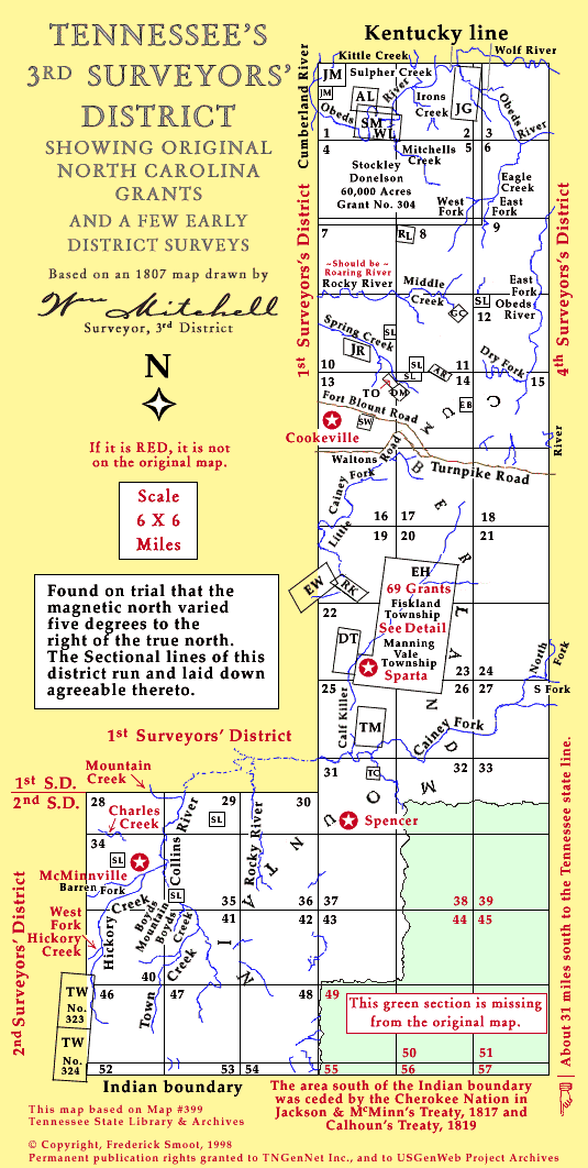
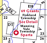
Click Here For Detail Map

Key  Name             Section  Date
AL   LYTLE, Archd        S1    1800
        N. C. Land Grants Book "A", p. 244. TSLA MF #1.
AR   RAWLIN_, A          S14   Not identified
EB   BRYUM, Ebenezer     S14   1794
        N. C. Land Grants Book "A", pp. 114, 115. TSLA MF #1
EH   HARRIS, Edward      S22+  1796
        N. C. Land Grants Book "C-3", p. 374.  TSLA MF #6
EW   WILLIAMS, Eliza     S19   1796
        N. C. Land Grants Book "A", 237.TSLA  MF # 1.
DM   DOUGLASS & M--?     S13+  1793
        N. C. Land Grants Book "6", p. 501. TSLA MF #17
DT   DONELSON, Stockley & TERRILL, W.
                         S22   1796
        N. C. Land Grant Book "C-3", p. 355. TSLA MF #6
GC   CHRISTIAN, Gilbert  S11   1793
        N. C. Land Record Book "A", pp. 91, 92. MF #1.
        Also Book 8, p.623. MF #19.
JG   GADDY, John         S2+   Not identified
JM   MEENES, J           S1    1794
        N. C. Land Grant Book 11, p. 115. TSLA MF # 22..
JM   MEENES, J           S1    Not identified
JR   RICE, John          S10   1802
        N. C. Land Grant Book "A", p. 253. TSLA MF #1
RK   KING, Robt          S19   1797
        N. C. Land Grant Book "A", pp. 223-224. TSLA MF #1.
RL   LYPERT, R.          S8    Not identified
SD   DONELSON, Stockley  S1-6  1796
        N. C. Land Grant Book "A", p. 218. TSLA MF #1.
SL   SCHOOL LAND         640 acres each
        Schools, for the use of  
                         S10   1807  p. 320.  
                         S11   1807  p. 321.  
                         S12   1807  p. 321
                         S14   1807  p. 321
                         S29   ----  p. 323  
                         S35   ----  p. 324  
                         S34   ----  p. 324  
        TSLA Record Group 50, MF #36, Book 39.
        3rd Surveyor's District, Plats and Surveys. 
SM   MARTIN,             S1    1807   
        TSLA Record Group 50, MF #35, Bk 34. p. 1.
        3rd Surveyor's District, Plats and Surveys. 
SW   WILLIAMS, S.        S13   Not identified
TC   CLARK, T. N.        S31   Not identified
TM   McCORRY, Thomas     S25   Not identified
TO   O'NEAL, T.          S13+  Not identified
TW   WADE, Thomas        S40+  1796
        N. C. Land Grants Book "A", p. 235. TSLA MF #1
WL   LYTLE, W.           S1,2  Not identified

G. Kay McGee researched the land grants for us. Thanks Kay!

Modern Counties in the Old 3rd District
(With Links to their Homepages)

Bledsoe
Clay
Cumberland
Grundy
Hamilton
Marion
Overton
Pickett
Putnam
Sequatchie
Van Buren
Warren
White


Land of Our Ancestors Home Page
Click Here

Maps Main Page
Click Here

Warren County Land Page
Click Here