The 1665 King's charter for the Proprietorship of Carolina specified its boundary as "All that Province, Territory, or Tract of ground, situate, lying, and being within our Dominions of America aforesaid, extending North and Eastward as far as the North end of Carahtuke River or Gullet; upon a straight Westerly line to Wyonoake Creek, which lies within or about the degrees of thirty six and thirty Minutes [36° 30'], Northern latitude, and so West in a direct line as far as the South Seas; and South and Westward as far as the degrees of twenty nine, inclusive, northern latitude; and so West in a direct line as far as the South Seas." In 1728, the Virginia-Carolina line had been surveyed from the sea to the above-noted Peters Creek, following which, in 1729, seven of the Lords Proprietors sold their interests in North Carolina to the Crown whereupon North Carolina became a royal colony. (The eighth proprietor, Lord Granville, retained economic interest and continued granting land in the northern half of North Carolina. All political functions were under the supervision of the Crown until 1775.)
(
6)
The 1749 westward extension was much needed, but the halt at Steep Rock Creek (in present-day Johnson, Tennessee's northeasternmost county) was clearly short-sighted given Colonel James PATTON'S 1,946 acre grant. (Augusta Co, VA Surveyors' Book,
7) In fact, the abrupt stop at Steep Rock Creek was the beginning of hundreds of legal disputes over land claimed by Virginia and North Carolina (that part that later became East Tennessee), spanning more than a century and a half, many of them not settled until over a decade after the matter was finally taken to the U.S. Supreme Court in 1890 (
8).
Calloway notes that "In the fall of 1770 at Lochaber on the South Carolinian estate of Alexander CAMERON, [John] Stuart [His Majesty's Southern Indian Superintendent] again negotiated a treaty with the Cherokee, wherein they ceded a triangle of territory west of the Hard Labor Line meant to legitimize the squatter claims in the upper Holston Valley. Like the treaty of two years before, the northern anchor of the line remained as the Ohio at the mouth of the Kanawha, but the southern end of the line was moved seventy miles west from Fort Chiswell to a new point six miles east of the Long Island of the Holston. Thus it happened that the early frontier people thought they were settling legally on lands which were a part of the Virginia colony." (
9).
Although later disputes covered only a narrow band of land (about two miles wide), the Washington District of North Carolina, created in 1775 (parent of Washington County, Tennessee, created in 1777), thought by most to have covered most of East Tennessee, included very little of Sullivan County, Tennessee, which was instead from land claimed by Virginia:
1738 - 1769 Augusta Co., Virginia
1769 - 1772 Botetourt Co., Virginia
1772 - 1777 Fincastle Co., Virginia
1777 - 1779 Washington Co., Virginia
1779 - 1796 Sullivan Co., North Carolina
1796 - Present Sullivan Co., Tennessee
According to
Taylor, "About 1770, a portion of the tract (973 acres) was purchased by
Evan SHELBY and Issac BAKER. In 1771 Col. SHELBY, a noted Indian fighter, erected a fort on a hill overlooking what is now downtown Bristol. It was an important stopping-off place for notables such as Daniel BOONE and George Rogers CLARK, as well as hundreds of pioneers enroute to the interior of the developing nation. Shelby's Fort is best known as one place where
the
Battle of King's Mountain was planned." (
10)
Marylander Evan SHELBY and one Isaac BAKER had purchased the Sapling Grove tract from the executors of James PATTON in 1768-1771 for £304 each with BAKER'S deed describing the transaction as "...978 acres, being a part of a tract of 1986 acres, on Shallow Creek, a branch of the Middle Fork of Indian (now Holstein) River..." (Washington Co, VA DB2:96), and SHELBY'S as "973 acres on Shallow Creek, a branch of Beaver Creek..." (Washington Co, VA DB2:261)
(
11)
Evan SHELBY took the oath of allegiance in Washington County, Virginia in 1777 and his son, Isaac SHELBY in 1779. (
12) Goodspeed's
History of Sullivan County, Tennessee relates:
"Gen. Evan SHELBY located on Beaver Creek, at what was known as the Beaver Dam Bottoms, in 1771, where he erected a fort on an eminence overlooking the site of Bristol. He was born in Wales in 1720, and before coming to Tennessee had taken an active part in the French and Indian war on the borders of Maryland and Pennsylvania. He commanded a company of militia from Sullivan County at the battle of Point Pleasant, and was the leader of the famous Chickamauga expedition. Afterward he was appointed by Virginia a general of her militia. He died in 1794, and was buried in the old family burial ground at Bristol, which was removed a few years ago. His son, Isaac, was made a lieutenant of militia in 1774, and as such participated in the battle of Point Pleasant. In 1776 he was appointed commissary, which position he held at the battle of Long Island Flats. Prior to the extension of the boundary line between North Carolina and Virginia, he served a term in the Legislature of the latter State. His last public service in Tennessee was as commander of the regiments at King's Mountain. Evan SHELBY, Jr., was a major in his brother's regiment at King's Mountain. In 1790 he went to Kentucky, where he was killed by the Indians about three years later...The BLEDSOES and BEELERS located on land adjoining the SHELBYS. The BEELERS owned the tract of land on Cedar Creek known as Sapling Grove [sic]." (13)
Calloway adds:
"The second mercantile establishment in the settlements was actually a combination trading post, way station, and stockade erected north of the Watauga by hard-drinking Evan SHELBY, a Marylander originally from Wales. This fort, known as Shelby's Station, covering over an acre and a half, was built on a hill above Beaver Creek (above the corner of present-day seventh and Anderson streets in Bristol, Tennessee) as a bastion against the Indians. During the French and Indian War SHELBY was a scout with BRADDOCK and commanded a company with FORBES. Afterward, he became a fur trader amont the Indians. During his travels in and out of the western wildrness, he heard about a tradesman named William BEAN and a farmer, James ROBERTSON, who had settled on the Watauga and the Sycamore Shoals, respectively... He first appeared in what is now the East Tennessee country about the close of the year 1770 and was excited by all he saw. He wrote his sons of his satisfaction with the territory, telling them that the soldiers and officers of the French and Indian War would undoubtedly receive grants of land there, and for them to purchase as many of the grants as possible. They did as he suggested.
"The following year, at the age of 51, Shelby moved his family to the Holston Country and settled at a place called "Big Camp Meet" (now Bristol, Tennessee-Virginia). The place was a prehistoric Indian village named, according to legend, because numerous deer and buffalo met here to feast in the canebreaks. An Indian trail, which the early settlers would traverse, followed an old Buffalo path from what is now Bristol to present-day Blountville. Shelby renamed the site Sapling Grove (which would later be changed to King's Meadows and still later to Bristol). Here, the Shelby family engaged in merchandizsing, farming and cattle raising (Lay, 5)."
(14)
In the late 1770s, an election for representatives of Washington County, Virginia was contested when Arthur CAMPBELL and William EDMISTON claimed that Anthony BLEDSOE [the Shelby's "next door neighbor"] and William COCKE had secured their election through votes of citizens of North Carolina. The contest was unsuccessful as Virginia was declared to extend as far down as Long Island, Kingsport in now-Sullivan County. (
15)
The following year BLEDSOE and CAMPBELL were elected, and BLEDSOE authored a bill which passed that provided for the extension of the line between Virginia and North Carolina with Thomas WALKER and Daniel SMITH appointed surveyors. (
16) North Carolina's legislature also passed legislation to extend the NC-VA line, appointing as commissioners any three of Oroondates DAVIS, John WILLIAMS, James KERR, William Baily SMITH and Richard HENDERSON. (
17)
The appointments of WALKER and HENDERSON probably guaranteed a disputed line: WALKER was a member of the Loyal Company of Virginia (
18) and HENDERSON a member of the Transylvania Company of North Carolina (
19). In his introduction to the
1750 Journal of Dr. Thomas Walker, Samuel Cole Williams points out that both Col. Walker and Judge Henderson had additional interests to protect.
Thomas SHARP and Anthony BLEDSOE led the militia company that was to act as escort to the commissioners, who met in the summer of 1799 at Steep Rock, where they encountered the first of many obstacles to come: "The place where Messrs. Fry and Jefferson ended their line on Steep Rock Creek could not be found, owing, we suppose, to so much of the timber thereabouts being since dead." (
20) Using calculations, both mathematical and astronomical, the Commissioners nevertheless began the line, which they extended forty-five miles to Carter's Valley (later Hawkins Co, TN). Once at Carter's Valley, however, the Commissioners disagreed, the North Carolina party declaring that the line was running too far south, it being "supposed the variation was caused by some iron ore influencing the needle of their instrument." The Virginia Commissioners suggested that two lines be run, the correct one to be determined later. This was initially agreed to, then declined, although two lines were run as far west as the Cumberland mountains.
(
21)
In the meantime, on 30 Sep 1779, William COCKE brought matters to a head when he refused to pay taxes to Virginia, as is evidenced by the 20 Oct 1779 Washington County, Virginia Court Minutes:
"On Complaint of the Sheriff against William COCK for Insulting and obstructing Allexander DONALDSON Deputy Sheriff when collecting the publick Tax about the Thirtieth of September last and being Examined saith that being at a fourt on the North Side of Holstein River in Carters Valey collecting the publick Tax the said William COCK as he came to the Door of the House in which said Sheriff was doing Business said that there was the Sheriff of Virginia collecting the Tax and asked him what Right he had to collect Taxes there as it was in Carolina and never was Virginia that he said the people was fools if they did pay him publick dues and that he dared him to serve any process whatever that he said COCK undertook for the people upon which sundry people refused to pay their Tax and some that had paid wanted their Money Back again." The Court ordered that "the Conduct of William COCK Respecting his Obstructing Insulting and threatning the Shefiff in Execution of his office be represented to the Executive of Virgnia," and that "if William COCK be found in this County that he be taken into Custody and caused to appear before the Justices at next Court to answer for his conduct for obstructing the Sheriff in Execution of his office. William CAMPBELL" (22)
Also in October 1779, the North Carolina legislature passed the Act creating Sullivan County, the second county formed in what is now Tennessee (if one discounts Washington and Russell Counties, Virginia), its boundaries described as:
"...to begin on the Steep Rock; thence, along the dividing ridge that separates the waters of the Great Kenhawa and Tennessee (?) to the head of Indian Creek; thence, along the ridge that divides the waters of Holston and Watauga; thence, a direct line to the highest part of the Chimney-Top Mountain, at the Indian boundary," with the new county to include "all of that part of Washington County, Tennessee lying north of a line formed by the ridge dividing the waters of the Watauga from those of the Holston, and extending from the termination of this ridge to the highest point of the Chimney Top Mountain." (23)
That the SHELBYS were now residents of Sullivan Co, TN is further evidenced by records of a February 1780 meeting at which the new county court was organized (at the house of Moses LOONEY), at which time a commission was presented appointing as justices of the peace Isaac SHELBY, David LOONEY, William CHRISTIE, John DUNHAM, William WALLACE and Samuel SMITH. Isaac SHELBY exhibited his commission dated November 19, 1779, appointing him colonel commandant of the county. (ibid.)
Despite the formation of Sullivan, use of the term, "Squabble State," became a commonly accepted description for the "no man's land" between Virginia and North Carolina (East Tennessee), with many of the residents and landowners who resided between the Henderson and Walker lines (about two miles apart) declining both military duty and payment of taxes to either state.
(
24)
Taylor notes that "After the Rev. War, the SHELBY land was purchased by Col. James KING a veteran of the War of Independence, and became known as "King's Meadow," and that when "he learned that a railroad might be coming to the area, Joseph ANDERSON, a son-in- law of James KING purchased 100 acres of land and laid out the tract into lots and streets. He anticipated that it might become a great industrial center and named it after Bristol ,England." (ibid.)
Goodspeeds adds that, "In 1786, Hawkins County having been erected, the Legislature of North Carolina passed an act to remove the seat of justice to a more central location, and appointed Joseph MARTIN, James MCNEIL, John DUNCAN, Evan SHELBY, Samuel SMITH, William KING and John SCOTT as commissioners to select a site for the county buildings. Meanwhile the courts were ordered to be held at the house of Joseph COLE. For some cause the seat of justice was not permanently located until 1792, when James BRIGHAM conveyed thirty acres of land to John ANDERSON, George MAXWELL and Richard GAMMON, commissioners appointed by the county court to erect a courthouse and jail. These commissioners seem also to have failed to do the duty assigned them, for in the act of the territorial assembly establishing the town, passed in 1795, James GAINES, John SHELBY, Jr., John ANDERSON, Jr., David PERRY, Joseph WALLACE and George RUTLEDGE were appointed to complete the courthouse..." and that "The first plat of Bristol was changed somewhat upon the survey of the Tennessee & Virginia depot grounds by C. H. LYNCH. He located Shelby Street, and the reserve made by Mr. KING of the old burial ground, wherein reposed the remains of Gen. Evan SHELBY, and several of the near relatives of Mr. KING until 1872, when they were removed by order of the mayor and aldermen..."
In the meantime, North Carolina had offered to cede her "western lands" (now-Tennessee) to the U.S. Congress with the stipulation that until such time as the cession was accepted, these would remain under the authority of North Carolina. The cession was signed into law by President George Washington on 16 Apr 1790, and on 26 May 1790, Congress deemed these lands the Territory South of the Ohio River, including a stipulation that until such time as the new Territory had enacted its own laws, that it would be bound by the lately re-enacted Ordinance of 1787 and laws of North Carolina, as applicable. On 11 Dec 1790, North Carolina, by an Act of Assembly, accepted the Walker line as the northern boundary between North Carolina and Virginia -- from the Atlantic Ocean to the Mississippi River. Newly-appointed Territorial Governor, William Blount, immediately protested, claiming that North Carolina no longer had the right to determine boundaries west of the boundary between that state and the new Territory, and that the Henderson line was the Territory's northern boundary. North Carolina ignored Blount's protest, as did Virginia a year later, when that state's assembly accepted Walker's line as their southern boundary. (
25)
After Tennessee achieved statehood in 1796, the boundary issue still unresolved, Virginia passed legislation approving the appointment of three new commissioners, Gen. Joseph MARTIN, Creed TAYLOR and Peter JOHNSON, and in 1801, Tennessee appointed Moses FISK, Gen. John SEVIER and Gen. George RUTLEDGE to corresponding positions. The new commission determined to run a parallel line equidistant from the Henderson and Walker lines w/ Brice MARTIN (son of Gen. Joseph) and Nat B. MARKLAND the surveyors. The "compromise survey" was agreed to by both states, but by 1856 the line had "by lapse of time, the improvement of the country, natural waste and destruction and other causes, become indistinct, uncertain and to some extent unkown, so that many inconveniences and difficulties occurred between the respective citizens of both states, as well as in the administration of their governments." (
26)
Tennessee appointed Col. George R. MCCLELLAN and Samuel MILLIGAN, and Virginia appointed Leonidas BAUGH and James C. BLACK. The commissioners were accompanied by Prof. Revel KEITH, an astronomer, and Charles S. Williams, a practical engineer, and the line later became known as the Baugh and Black line. In a report to Tennessee Governor Isham G. Harris, the commission wrote: "We began the experimental work at the town of Bristol, a small village situated on the compromise line of 1802, at a point where there was no controversy as to the locality of the line, and our first observation at that point showed the latitude to be 36° 36'." (ibid.)
Virginia, however, did not approve the 1856 survey, and in 1860 instead made provisions for the appointment of another set of commissioners. Due to the Civil War, no action was taken, but in 1871-2, Tennessee appointed another commission, which, upon an initial investigation, defended the compromise line of 1802. In 1890, the issue came before the U.S. Supreme Court with both a history of the dispute and numerous witnesses provided, one of whom, like John HACKER and John McQUEEN, confused Henderson and Walker with Mason and Dixon. In 1891, the highest court in the land decided in favor of Tennessee; i.e., that the Compromise Line of 1802 was the correct line, and in April 1900, a commision was appointed to retrace and re-mark the Compromise Line of 1802, a task completed in 1901-02. (ibid.)
THE OLD BLOCKHOUSE & SHELBY'S FORT
Shelby's Fort was apparently created on the site of the "old Blockhouse." John HACKER implies they were one and the same when he states "When I was a well grown boy, I was taken and placed in the old block house (afterwards called SHELBY's Fort) between where Jonesborough now stands and Saulsbury." Likewise, John FIELDS states that "...most all the soldiers was mustered into the service at forte SHELBY or Selby which was called before that time Old Block House afterwards rebuilt and called fort Selby after General SHELBY or Selby." HACKER and COMBS mis-identify the surveyors (apparently confusing Henderson and Walker with Mason and Dixon), with only John FIELDS correctly identifying the two.
Still confusing is why the fort is referred to as lying between Jonesborough and Salisbury since it was northwest of both... as the crow flies (research as to actual routes is still in progress). Erstwhile Tory Nicholas COMBS' statement that the fort was in Surry or Wilkes Counties, North Carolina, may have been confused by the fact that Surry was the parent county of both Washington District and Wilkes County.
COMBS had apparently still been a resident of Surry in 1780 when, according
to the 1804 Hawkins Co, TN affidavit of Isabel BACON, he and John GOWINS
(believed to have been his uncle) had robbed William Terrell LEWIS
in Wilkes County, North Carolina. Capt. William Terrell LEWIS commanded troops from (primarily) Surry and Wilkes Cos NC, and was also closely associated with the COMBS-RIDGE Families of those counties. (It was William Terrell's brother, Capt. Micajah LEWIS who "half-hung"
Tory William COMBS in 1778).
Based on his own statements, Nicholas COMBS apparently enlisted in late 1780 or early 1781, and both he and John HACKER agree that he was discharged about November 1781 (shortly after Cornwallis' surrender at York). John HACKER and John FIELDS both stated that COMBS had enlisted at Shelby's Fort, but it was as likely that he accompanied LEWIS to that site (his father, John COMBS, was still residing in Surry County at the time and until at least 1786, and his uncles Mason and William COMBS were still in then-Montgomery County, Virginia, according to a
1781 Montgomery County Militia List). For at least a short period after 1781, Nicholas returned to his birthplace, Shenandoah Co, VA, where he was taxed in 1782 to 1785. He disappears from all records from 1786-1795, following which he appears on the
1796 Sullivan Co, TN tax list with 400 acres which his descendants claimed was at Long Island, Kingsport, Sullivan Co, TN. COMBS still owned this land as late as 1812, although he was by then residing in Clay Co, Kentucky.
John HACKER states that upon Nicholas COMBS' return "back to the neighborhood" that "his family was then in part in the fort and part was not." Since his father, John, appears to have still been in Surry, the referenced "family" was possibly his Tory relatives (See George Baumbach's
Estate File of William
RIDGE, late husband of Nicholas' aunt, Winnifred COMBS).
One John COMBS appears on a
1788 Sullivan Co, TN Militia List of the above-referenced Capt. Thomas VINCENT, as does Lt. Samuel BRESHEARS. HACKERS' mention of Nicholas COMBS' brother, John, makes it likely that he was the John COMBS of 1788.
FIELDS stated that his company moved from place to place to build forts, including SHELBY'S and BLEDSOE'S, and added later that their "base of operation included from Shelby's fort to the Tennessee river, from 150 miles to 2 hundred miles backward and forward..." At some time during the War, the BLEDSOES moved from Squabble State to middle Tennessee, and the reference to their fort may have been in the latter location. (
27)
No McQUEEN or McQUIN records have been located as yet, possibly indicating they lived further south (TN not having been researched as deeply as VA as yet). No MULLINS have been located in the VA records either (although this may have been McMULLIN).
Squabble State Land Records offer more confirmation of where Squabble State lay, but still not solved is the mystery of why Nicholas COMBS and John HACKER referred to Shelby's Fort as lying between Jonesborough and Salisbury (Shelby's being almost due north of Jonesborough and Salisbury lying west-southwest. The answer to this may lie in the roads at the time (work in progress).
To be continued... a work in progress
_______________
1
Revolutionary War records of Nicholas COMBS
2
Revolutionary War pension file of John FIELDS
3
Revolutionary War pension file of John McQUIN/McQUEEN
4
North Carolina Surveyor William CHURTON. See also William CHURTON and William COMBS of Orange Co, North Carolina (relationship to Nicholas COMBS, if any, unknown at this time).
5
1751
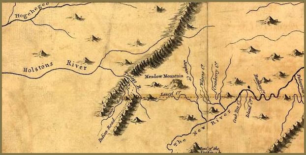
Fry-Jefferson Map, 2 mg (See also the smaller
Southwest
1751 Fry-Jefferson Map).
6
Historical Highlights of North Carolina: Colonial Period, North Carolina Encyclopedia, State Library of North Carolina
7 "America's First
Western Frontier: East Tennessee," Brenda C. Calloway, Overmountain Press,
Johnson City, TN, 1989, hereinafter Calloway
8 U.S. Supreme Court, Virginia vs. Tennessee, 1891, 148 U.S. 503, 37 L.Ed. 537, "Historic Sullivan," Oliver Taylor, 1909, reprint Overmountain Press, Johnson City, TN, 1988, hereinafter Taylor
9 Calloway; and 1770 Treaty of Lochaber
10 Gerald H. Clark's "The Militia of Washington Co, VA "(1979)
11 Annals of Southwest Virginia, 1769-1800, Vols. I & II, Lewis Preston Summers, 1929, reprint, Overmountain Press, Johnson City, TN, 1992, hereinafter Summers. Note: Taylor states the purchase was in 1770, Calloway that it was in 1768, and Goodspeeds in 1771. Earlier deeds have not yet been located, but the Washington County, Virginia deeds were both recorded in the late 1790s , possibly for the sole purpose of ensuring title (full transcription not yet reviewed).
12 Source not stated, probably House of Burgess records. "Historic Sullivan," Oliver Taylor, 1909, reprint Overmountain Press, Johnson City, TN, 1988
13
Goodspeeds' History of Tennessee, Sullivan County, The Goodspeed Publishing Company, Chicago and Nashville, 1887, hereinafter
Goodspeeds.
14 Calloway
15 Summers and 1770 Treaty of Lochaber
16 Summers
17 Ramsey
18 1770 Treaty of Lochaber
19 1772 Henderson Purchase, Treaty of Sycamore Shoals
20 "Report of Messrs. Walker and Smith to the legislature of Virginia, on the Boundary Line between the Staets of Virginia and North Carolina, Civil and Political History of Tennessee from Its Earliest Settlement up to 1796, Including the Boundaries of the State, John Haywood, 1823, Publishing House of the Methodist Episcopal Church, South, Barbee and Smith, Agents, Nashville, TN, 1891, reprinted Overmountain Press, 1991, p. p.487
21 Ramsey. Despite being several miles too far north by the time they reached the Cumberland River, the Walker party continued on, not only to the Tennessee River, but on to the Mississippi, with each mile westward widening the gap between the "true line" and Walker's line. This was later also the cause of years-long disputes between Tennessee and Kentucky, primarily because the boundary issues between Tennessee and Virginia and those between Tennessee and Kentucky, although both initially revolved around the Walker Line, were treated separately. This was in part due to President Thomas Jefferson's request to William Blount, then governor of the Territory South of the Ohio River (created in 1790 by Congress, and in existence until 1796 when it became the state of Tennessee), in a letter dated 6 Jun 1792, that the settlement of the boundary with Kentucky be postponed so that the two governments would not break into conflict over the state boundary right away. (Land Registration In Early Middle Tennessee, Laws And Practice, Chapter III, The Territorial Government, Daniel Byron Dovenbarger, hereinafter
Dovenbarger. See also Obion Co, TNGenWeb host Jane Norton Powell's
Walker and Winchester Lines; Sandi Gorin's
The Walker Line and a 1921 article by R S Cottrill, reprinted in the
Kentucky Explorer (Vol 12, No. 2, June, 1997, pp. 43-44), in which he details the cause and effects of Tennessee-Kentucky Walker Line disputes.
22 Summers
23 Ramsey and
Goodspeeds
24 Taylor
25 Dovenbarger, Chapter III
26 Taylor
27 According to Ramsey (p. 190), "Anthony Bledsoe had lived, in 1769, at Fort Chisel [Chiswell], and, in a short time after, with his brother Isaac and the Shelbys, removed further west, into what is now Sullivan County. His station was not far from Long Island..." The Bledsoe brothers removed to the Cumberland Settlement shortly after the Battle of King's Mountain and among the commissioners appointed at the first court of the newly-created Davidson County, Tennessee on 6 Oct 1783 were Anthony and Isaac Bledsoe, as well as David Smith, the Virginia Walker Line Surveyor (ibid., pp. 494-5). Ramsey also refers to Col. Anthony Bledsoe, having "broken up his own fort, on what was known as the Greenfield Grant," by 1788, having moved "into the fort of his brother, Isaac Bledsoe, at Bledsoe's Lick, and occupied one end of his house" (Ramsey adds that Col. Anthony Bledsoe was killed there during an Indian attack in July of that same year (pp. 479-80), and later mentions Henry Ramsey having been shot "near Bledsoe's Creek, between Greenfield and Morgan's Station, three or four miles from Bledsoe's Lick." (p. 483)). According to Ramsey, both Anthony Bledsoe was appointed Colonel of the militia, and Isaac his major. According to Ramsey

