TNGenWeb
Project
LAND REGISTRATION IN EARLY MIDDLE TENNESSEE
LAWS AND PRACTICE
By Daniel Byron Dovenbarger, ©
{ Page 45 }
CHAPTER III
THE TERRITORIAL GOVERNMENT
Congress, by accepting North Carolina's cession, caused the metamorphosis of
Tennessee land from the western part of a seaboard state to the main portion of a
frontier territory. It must be surprising, therefore, to discover there was actually little
alteration of the land law system established by the General Assembly of North
Carolina. This inactivity of the territorial government is significant since the rationale
for public sale of the land was different for the two governments.
In North Carolina, the purpose for encouraging land sales was of a double nature.
First, the state was interested in obtaining income from the sale of the lands. The funds
obtained from land sales were a valuable addition to a state treasury that had suffered
the effects of the Revolutionary War and its economic aftermath. Additionally, the state
saw its best interest to lie in providing a regulated system of encouragement for the
new settlers entering the lands. Another aspect of North Carolina's land policy was that
the state used the lands to eliminate its obligation to its soldiers. The land of the
western territory had been a valuable commodity in the state's economy. Accordingly,
one would suspect that the laws passed affecting the disposal of that land were geared
to benefit the state and, perhaps, those who found themselves in positions where they
could write those laws to benefit themselves.
In the Territory South of the River Ohio, different circumstances prevailed. Since
all inhabitants (white settlers and their slaves) migrated into the territory from the
eastern states, there were none of the obligations that affected state policy for
governments in existence during the Revolutionary War. At least this is how it should
have been in theory. The territorial government as a new creation should have had a
free hand in regulating the land under its control to the benefit of the settlers already
there and the newcomers streaming over the mountains.
Actually, North Carolina maintained certain rights to some Tennessee lands.
These rights were enumerated in the clauses of the Act of Cession of 1789. Such clauses
stipulated that military warrants either issued or in the process of being issued would
be allowed to be completed and validated. This stipulation was to have long-lasting
effects on the land policies and politics of the territory and later the State of Tennessee.
Further difficulties were created for the territorial government by the decision of
Congress to use the land in the area to relieve the Federal government of its obligations
to soldiers. The results of this decision created in Tennessee a system where three
different governments all had some input into decisions made about the registration
and validation of land claims. The resulting confusion has done much to obscure a
great deal of Tennessee's past, both in how the state was settled and how the politics of
the young state developed.
Troubles emerged once Congress accepted the Act of Cession from North
Carolina. This Act of Cession was presented to Congress in February, 1790 by Benjamin
Hawkins, the Senator from North Carolina.
By April 16, 1790, actions taken upon the acceptance of
the cession resulted in George Washington signing the final documents necessary to the
legal transaction.(1) There was then a small lapse of time before the actual creation of
the territorial government.
The bill that finally emerged creating the Territory South of the River Ohio was a
small piece of legislation. It created the territory, in one district, into a governmental
unit with a system identical to that established in the Northwest Territory. This plan of
government had been detailed in 1787. Congress provided for certain exceptions to this
pattern for the new territory. Chiefly, the exceptions allowed the reservations made by
North Carolina but also permitted loopholes through which a different pattern of land
regulation than provided by the Land Ordinance of 1785 could continue in the territory.
Officers in the newly created territorial government were to be nominated by the
President and appointed with the consent of the Senate. The officers were to receive the
same salaries and have the same authority as officers in the Northwest Territory. The
bill creating the new territory was finished and signed by John Adams, President of the
Senate, and Frederick Augustus Muhlenberg, Speaker of the House, on May 26, 1790.(2)
Although it was the intention of Congress to provide a land system in the
territory similar to the one previously created in the Northwest Territory, there were
great differences in the two regions' land systems. Never in the history of land surveying in
Tennessee was there an energetic attempt to provide the systematic township pattern
prescribed for the Northwest Territory. Since portions of the Land Ordinance of 1785
regulated the appropriation of public land for the benefit of schools, the absence of that
system in Tennessee caused complications for school funding in Tennessee.(3)
After the bill creating the new territory had passed, there remained the difficult
task of finding who would best fill the positions created. A governor, a secretary to the
governor, and a judge were to be appointed. Recommendations for these positions
began coming to President Washington early in the summer of 1790. On June 5, 1790,
Timothy Bloodworth wrote to Washington encouraging the appointment of William
Blount as governor. This was followed with a recommendation that Robert Hays, the
son-in-law of John Donelson, be given the position of secretary. The same day other
recommendations were written. John B. Ashe, the governor of North Carolina, also
recommended William Blount as a good candidate for governor. This suggestion was
supported by Senator Hawkins of North Carolina.(4) Other nominees for the positions
were Howell Tatom and Daniel Smith for secretary and David Campbell and Edward
Jones for judge.
Finally, a memorandum was sent from Secretary of State Thomas Jefferson to
George Washington expressing Jefferson's conclusions as to who would serve best in
the new territorial government. Jefferson wrote that he had heard only good spoken of
William Blount. Apparently no other candidate for governor had as many supporters
as Blount. Jefferson went on to recommend Daniel Smith as secretary and David
Campbell as judge.(5)
It is not know what other information Washington might have collected on these
men, but he acted rapidly, accepting completely the suggestions of Thomas Jefferson.
The commission to William Blount as governor was issued on June 8, 1790. This was
approved by the Senate, creating his office for a period of three years or during good
behavior. During the summer the commission was relayed to William Blount, and on
September 20, 1790, he took his oath of office in Knoxville.(6) Issued the same day in
June, Daniel Smith's commission provided a four-year term or during good behavior.
He received his commission on September 6, 1790. Judge David Campbell was
appointed during good behavior or for the duration of the government.(7)
Although there had been little or no alternative to the appointment of William
Blount, there are some interesting reasons given for his interest in and accreditation for
the job. In a letter of May 28, 1790, Hugh Williamson, a representative to the House
from North
Carolina, and later to become deeply involved with the
Blounts in speculation, wrote Washington and suggested that the reason Blount would
make a good governor was his intense interest in the peace and prosperity of the area.
This interest stemmed largely from Blount's immense holdings of land within the
territory. One authority states that Blount's sole reason for seeking the governorship
was to enhance the value of his large holdings in Tennessee.(8)
Once the officers of the territory had been appointed, there was little direct
involvement of the national government with the policies of the territory. What contact
there was flowed through the Secretary of State, Thomas Jefferson. Much of the effort
of William Blount and his associates was spent in establishing a system of courts,
maintaining peace and making treaties with the Indians, and generally establishing a
comprehensive government. Clearly, the regulation of surveying and registration of
land was merely one of many important tasks facing the new government.
Nevertheless, Congress retained an avid interest in the disposal of lands in the
territory. An attempt to open a land office in the territory met with difficulties. A bill
authorizing such an office was first passed February 16, 1791 by the House. The bill
became delayed in the Senate, which felt it did not have enough information on the
territorial lands. By a resolution of March 3, 1791, Congress agreed to put off the land
office bill until the next session.(9) In the
meantime, they hoped to find some more information
on the lands available in the Territory South of the River Ohio. The resolution, passed
by both the House and the Senate, requested the President to discover how much
unclaimed land existed in the Territory. This information was to be prepared as a
preliminary guide for discussion of the bill for the opening of a land office at the next
session of Congress.(10)
The official responsible for collecting this information was Washington's secretary
of state. Thomas Jefferson began at once to collect information about the lands already
granted. In his correspondence with North Carolina he asked for copies of the returns
from John Armstrong's office, a list of claims of officers of North Carolina, and
information on General Greene's grant. This information was received by Jefferson as
he was completing his report.(11)
The report was to have problems not of Jefferson's making and not under his
control. Chief among these was the fact that the claims stemming from John
Armstrong's office would not be final until the last legal date for filing had passed. That
day was then established as December 20, 1792 by an extension law of North Carolina.
Since that was in the future, when Jefferson was preparing his report, little could be
done but accept guesses as to what would be the final extent of the land claimed under
the warrants issued by Armstrong.(12) Also, it would be almost impossible to gauge
the extent to which claims that had been filed would later be discovered to be invalid
through either fraud or error. Likewise, even though Jefferson did not know it
at the time, before December 20, 1792 arrived, North Carolina would again extend the
deadline for registering claims. This practice would continue until 1800.(13)
Of the information Jefferson collected, it appeared that warrants for 3,736,493
acres had been issued. At the time Jefferson requested the information, only about
1,762,660 acres of this amount had been granted.(14) Based on these estimates, Jefferson
supposed that all non-Indian land within the Territory worth cultivating had been
claimed.(15) In a letter to Jefferson, Daniel Smith reported that the entry-taker of
Davidson County had recorded the claims of the commissioners, guards, surveyors,
packhorsemen, markers, and guides. Also recorded were the lands claimed under
pre-emption rights. At the time Smith wrote, some 407,780 acres had been claimed in
the manner he described. It was assumed that such claims would eventually reach at
least 410,000.(16) A partial breakdown of the total he presented shows 30,203 acres
granted as surveyor's fees, 65,932 acres granted to Shelby and others of the Commission
to establish state boundaries, and 309,760 acres granted to pre-emptors in Davidson
County.(17)
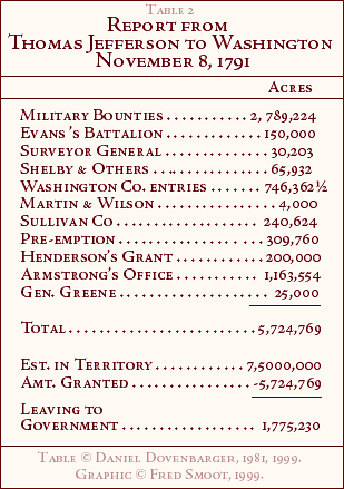
The report Thomas Jefferson tendered to George Washington was prepared by
November 8, 1791. As he submitted it to the President, Jefferson remarked, without
explaining why, that he had carefully refrained from trying to evaluate the validity of
the estimates he had received.(18) It might be wished that he had judged those
estimates, because at this distance in time it is more difficult to assess the validity of
those claims. Had Jefferson left his judgment to supplement our own, it would be
easier to establish the degree of error and fraud being carried on in the Territory.
Jefferson's words alone imply that some skepticism on the validity of these figures is
justified.
The report Thomas Jefferson submitted is best displayed in tabular form. Table 2
summarizes the major categories and amounts of claims.(19) According to this report,
there remained at least 1,775,000 acres in the Territory for the government to sell.
In the spring of 1792, the problem of land fraud first came to the attention of
Jefferson. Rumor in and around Congress indicated that grants had recently been given
by North Carolina in the area south of the French Broad and Holston Rivers. Jefferson
wrote to Blount then asking where those grants had originated.(20) Late in August of
that year, the matter was apparently resolved. Alexander Martin, of North Carolina,
wrote to inform Jefferson that grants had been issued by North Carolina for the lands in
question. These grants, he claimed, were only issued
{ Page 54 }
{ Page 55 }
for lands granted and then vacated prior to the cession.(21) In other words, North
Carolina was presuming to continue granting lands in the Territory simply because
earlier North Carolina grants had been vacated. Supposedly, North Carolina felt such
grants were still lands at the disposal of the General Assembly. Instructions from
Jefferson asked Blount to prevent new settlements from being established south of the
French Broad and Holston Rivers. A list was to be made of all the old settlers who had
legitimate pre-emption rights.(22)
Soon the true source of the land problem was revealed. A proclamation of
Alexander Martin, governor of North Carolina, disclosed a land fraud in the form of
supernumerary claims, on the lands south of the French Broad and Holston Rivers. By
calling their claims lost, certain men had been able to get duplicate grants from the
Armstrong office. This duplication of grants was illegal. The governor's proclamation
notified the public that such practices would be subject to prosecution.(23)
This problem concerned the Territory because settlers in the area were having
problems getting their land claims validated. Thomas Jefferson, in a letter to William
Blount, instructed Blount that when a grantee in the questioned area south of the
French Broad and Holston Rivers was not in possession of the land, the governor
should warn him against taking possession. The rights of the United States were to be
secured in such cases by keeping the land under Federal title until the
illegal, duplicate entries were discovered. This instruction applied only in cases where
the grantee had not yet taken possession.(24)
Other important land difficulties had to do with the new Territory's attempts to
distribute land and the relationship of the government to the Indians in the region. The
lands under the difficulty mentioned above lay south of the French Broad and Holston
and had been reserved for the Cherokee by a treaty with North Carolina in 1783.
Nevertheless, the lands had been entered and even granted by the state. The
pre-empting settlers were clearly on the wrong side of the treaty line, but were allowed
to perfect their titles.(25) A new treaty, the Holston Treaty of 1791, extinguished the
Cherokee rights to this tract of land.(26) Later, the first Tennessee Constitution of
February 6, 1796 guaranteed settlers in the area occupancy and pre-emption rights.(27)
Likewise, the grant of two hundred thousand acres given to Richard Henderson
in partial compensation for the losses of the Transylvania Company was discovered to
lie largely in Indian Territory along the Powell and Clinch Rivers. Grants to Alexander
Martin, David Wilson, and Nathaniel Greene were also found to be in Indian
Territory.(28) These discoveries tended to exacerbate an already difficult land-granting
situation. The state of North Carolina clearly had no right to grant such land; however,
that state was no longer responsible for the validation of grants. Increasingly, the
Territorial government was faced with validating claims of dubious legality.
The military bounty area, pictured in the last chapter, had been defined by the
General Assembly of North Carolina as a rectangle. The Indian treaty lines, however,
followed major rivers and streams. The result was that even in the defined military
bounty area, there were large triangles of land in the southeastern and southwestern
which by treaty belong to the Indians.(29) The pressure to acquire or appropriate these
areas was immediate and important to the developing policies of the Territorial
government: having these difficulties clouded land titles in the areas affected for a long
time to come.
Additional events uncovered more irregularities from John Armstrong's
office. A petition in 1794 for justice from the general Assembly of North Carolina was
signed for the benefit of grantees of land under Armstrong's office.(30) It is not known
exactly what this petition contained, but apparently the grantees had discovered great
errors in their grants. Other misdeeds of Armstrong's office were discovered later and
will be discussed later and will be discussed in the proper place.
It should be noted that at this time the University of North Carolina was
petitioning the General Assembly for a share of the western lands for the establishment
of a fund to operate the school. The history of the University of North Carolina and the
land question is extensive and tied directly to the designation of public lands for the
support of schools in Tennessee. The history of this aspect of land disposal in
Tennessee is adequately discussed in a number of different theses written at George
Peabody College for Teachers.(31)
An additional problem faced the Territorial government during the summer of
1792. This situation was due to the fact that Kentucky had just been admitted as the
first state west of the Allegheny mountains. Jefferson wrote to William Blount on June
6, 1792 asking Blount to postpone the settlement of the boundary with Kentucky so that
the two governments would not break into conflict over the state boundary right away.
It was suggested the Territory would do better to wait until the novelty of statehood
had passed before settling the issue.(32)
Although the determination of the boundary with Kentucky had been postponed,
the Territorial government had other boundary problems. The action of North Carolina
and Virginia created this problem. In establishing their mutual boundary, North
Carolina, on December 11, 1790, designated the Walker line as the northern boundary;
while a year later, Virginia's Assembly concurred and established by law the Walker
line as the southern boundary of that state.(33) In the
meantime; however, William Blount, as governor of the southwest Territory, had
explicitly denied the right of either of those states to determine the northern boundary
of the Territory.(34) Blount was acting correctly in defending the interests of the
Territory and the Federal government. Since Virginia's southern border shared some of
the Territory's northern border, a designation of Virginia affected the Territory. In
protesting Virginia's action of 1791, Blount wrote to Henry Lee, Governor of Virginia,
on September 2, 1792. Blount proclaimed in this letter the northern boundary of the
Territory to be the Henderson line.(35) This was the northernmost line established by
the troubled commission of 1779-1780. In 1791, trouble erupted in the area of territory
between the two lines, with citizens claiming to be in the jurisdiction of the government
which required them to pay the lesser amount of taxes.(36) This problem was not
resolved by the Territorial government. It was passed on to the state government of
Tennessee to settle over a long period of time.
A brief examination of the controversy Tennessee inherited indicates the
longevity of the problem. The Constitution of Tennessee, created in 1796, defined the
boundaries using the Henderson line as the northern border.(37) Subsequently Virginia
asked Tennessee to establish a new commission to mark the border in 1800.(38)
After that the line was re-run in 1856, 1858, and 1871. The argument was re-broached in
a court case of 1889. It was not until 1903 that the border issue was finally settled.(39)
In terms of concrete acts, the legislative council of the Territory under William
Blount did little relating to the survey or registry of land. The first action on August 25,
1794 merely was an extension of the time allowed for the registry of lands, deeds, and
other conveyances. Other action provided for the authorization of funds to construct a
road from Knoxville to the Mero District.(40) This action did not alter the laws
inherited from North Carolina. On June 29, 1795, the legislative council for the
Territory passed a second act relating to land. This act established a source of income
for the construction of the road into the Mero District. The money was to come from
the sale of salt licks within the Territory. A group of commissioners empowered to
build the road received the funds.(41) This group contained James White, James
Winchester, Stockley Donelson, David Campbell, and Robert Hays. Campbell was still
judge of the Territory, while Hays had been a candidate for the office of secretary.
With these two enactments the Territorial government completed its action
regarding lands. The absence of other land laws, including action altering the system
established by North Carolina, is puzzling. One possible explanation is that pressures
which created the trends seen in North Carolina's land laws were not operating in the
Territory. Until 1794, there was no Assembly in the Territory. The governor was free of
the popular pressure which served to formulate North Carolina's increasingly stringent
land laws. Also, North Carolina had needed the money from the sale of lands. Its land
system was continually updated to insure the proper collection of funds and to detect
fraud. As this study progresses, the land transactions of the Blounts are examined.
What is learned there gives indications of why the only land laws passed while William
Blount was in office consisted of an extension law and a sale of salt licks to finance a
road. Both of these bills were favorable to speculators.
Additional reasons for few land bills being passed in the Territory are found by
realizing Governor Blount had been influential in North Carolina and probably felt the
land laws in effect were both usable and beneficial; after all, he had monitored their
passage in North Carolina. Also, as long as there was no crisis in the public use of the
laws, there was probably little energy left over from other aspects of governing a new
territory to focus on the land registration laws. What is more, most men dealing with
the land issues of the day were familiar with the system in operation. It would have
been more confusing to add additional laws to the already overloaded system in
operation.
As the time drew near for the Territory to become a state, changes were
necessary. First of all, Tennessee county was divided into Montgomery and Robertson
counties. The name of the old county was appropriated by the new state.(42) Problems
created by the confused picture of land surveying and registry did not disappear with
the creation of a new state, however. The Territorial government had not made any
beneficial changes in the land system. Instead, the Territory passed along to the new
state the mess of legislation inherited from North Carolina. The story of Tennessee land
laws is a long and complicated one in its own right. Some evidence of the troubles
encountered in the new state is found in the fact that a new breed of surveyors had to
develop to handle the situation. In rural Tennessee, men who could trace out the
original grants and boundaries from prior knowledge and intuition came to be known
as "Red Brush" surveyors. Gradually, this "Red Brush" method died out too, as land
titles became more secure and well documented.(43)
Tennessee at least managed to obtain some sort of control over the lands within
its borders. First of all, however, it was recognized as North Carolina's agent in the
distribution and validation of Revolutionary War claims. This persisted well into the
state's early history. Additionally, Tennessee lands were sometimes under the control
of Congress. Repeatedly Tennessee asked Congress to release the lands south and west
of the Congressional Reserve line. It was not until 1846 that
this was accomplished.(44) Even then, certain
categories of congressional lands in the area remained under the jurisdiction of
Congress until 1906.(45)
Thus, it can be seen that the land history of Tennessee was to be long and
complicated. Tennessee has always had to contend with the basic system created by the
laws of North Carolina and passed on by the Territory South of the River Ohio. These
laws in turn were affected by the character of the period in which the Tennessee valleys
were explored and settled.
Looking at the territorial acts shows that the trends of land legislation in North
Carolina were reversed after the Act of Cession. Updating efforts of North Carolina's
assemblies, seeking to control surveyors and speculators, were stopped and not
resumed by the Territory South of the River Ohio. The inaction of the territorial
government does not prove that it was more favorable to speculators, but it seems odd
that North Carolina during this period continued to unveil and prosecute fraudulent
practices while the Territory did not. Much of the fraud uncovered dealt with
Tennessee lands, but the territorial government apparently did not seek to prosecute
any fraud. Later, the State of Tennessee became uncooperative when North Carolina
attempted to prosecute some of the Blount family.(46)
The territorial government was no doubt busy in its early days. It had to contend
with early illegalities discovered in lands encroaching on Indian territory. The new
government also had to safeguard its interests along the northern border. As to land
law, however, the territorial government did not follow North Carolina's trend but
waited passively for a state to be created. Whether that passive waiting was beneficial
to speculators and the result of William Blount's own speculation can be estimated by
examining the records left to determine the extent of illegal speculation. This process is
done in the next chapter. Just looking at the trend of laws passed in North Carolina and
the abrupt halt of that trend after cession creates a suspicion that the territorial days
were idyllic for speculators.
*Page 57 is missing from the two original copies that are available to us. One copy is
located at Vanderbilt University in Nashville Tennessee. The other copy is
located at the Tennessee State Library and Archives, also in Nashville.
Endnotes, Chapter III
(1) Clarence Edwin Carter, ed., Territorial Papers of the United States,
6 vols. (Washington, D. C.: United States General Printing Office, 1936), vol. 4:
The Territory South of the River Ohio 1790-1796, p. 17.
(2) Ibid., 4:18-19.
(3) See Maude Alexander, "Public Lands of Tennessee" (M.A. Thesis, George
Peabody College, 1927); Thomas B. Jones, "The Public Lands of Tennessee,"
Tennessee Historical Quarterly 27(1968):13-36; Jird H. Rippy, "A History of
the School Lands of Tennessee" (M.A. Thesis, George Peabody College, 1929); Kenneth
Wilson Warden, "The History of the Administration of the Tennessee School Fund"
(M.A. Thesis, George Peabody College, 1920); Sarah V. Williams, "History of the
Tennessee Public School Lands" (M.A. Thesis, Vanderbilt University, 1944); Sarah V.
Williams, "Tennessee Public School Lands," Tennessee Historical Quarterly
3(1944):335-48.
(4) Carter, 4:20-21.
(5) Ibid., 4:23-24.
(6) Ibid., 4:24.
(7) Ibid., 4:25.
(8) Ibid., 4:18-20, n. 31.
(9) Ibid., 4:36.
(10) Ibid., 4:48.
(11) Ibid., 4:69.
(12) Ibid., 4:91.
(13) Sarah V. Williams, "History of the Tennessee Public School Lands" (M.A.
Thesis, Vanderbilt University, 1944), p. 4.
(14) Carter, 4:92.
(15) Ibid., 4:92.
(16) Ibid., 4:105.
(17) Ibid., 4:105.
(18) Ibid., 4:84.
(19) Ibid., 4:99.
(20) Ibid., 4:143.
(21) Ibid., 4:143.
(22) Ibid., 4:155-56.
(23) Ibid., 4:191-93.
(24) Ibid.
(25) Ibid., 4:8.
(26) Ibid.
(27) Ibid.
(28) Ibid., 4:90.
(29) Ibid., 4:85.
(30) Alice Barnwell Keith and William H. Masterson, eds, The John Gray
Blount Papers, 3 vols. (Durham: Christian Printing Company, 1959),
2:182.
(31) Keith, 2:181; Plummer Battle Kemp, History of the University of North
Carolina, 2 vols. (Raleigh: Edwards & Broughton Printing Company, 1907-1912), vol. 1
1789-1868; A. L. Bramlett, "North Carolina's Western Lands" (PhD. Dissertation,
University of North Carolina, 1928); Maude Alexander, "Public Lands of Tennessee"
(M.A. Thesis, George Peabody College, 1927); Thomas B. Jones, "The Public Lands of
Tennessee," Tennessee Historical Quarterly 27(1968):13-36; Jird H. Rippy, "A
History of the School Lands of Tennessee" (M.A. Thesis, George Peabody College, 1929);
Kenneth Wilson Warden, "The History of the Administration of the Tennessee School
Fund" (M.A. Thesis, George Peabody College, 1920); Sarah V. Williams, "History of the
Tennessee Public School Lands" (M.A. Thesis, Vanderbilt University, 1944); Sarah V.
Williams, "Tennessee Public School Lands," Tennessee Historical Quarterly 3(1944):
335-48.
(32) Carter, 4:155-56.
(33) Lewis Preston Summers, History of Southwest Virginia 1746-1786
(Richmond: J. L. Hill Printing Company, 1903), p. 706.
(34) Ibid,
(35) Carter, 4:203.
(36) Ibid., 4:205-8.
(37) Summers, p. 709.
(38) Ibid., p. 710.
(39) Ibid., p. 714.
(40) Edward Scott, ed., Laws of the State of Tennessee including those of
North Carolina Now in Force in this State from the Year 1715 to the Year 1820,
Inclusive, 2 vols. (Knoxville: Heiskell & Brown, 1821), 1:507-8.
(41) Ibid., 1:516-17.
(42) Edward Albright, Early History of Middle Tennessee (Nashville:
Branden Publishing Company, 1909), p. 201.
(43) Helen Bullard Krechniak, Cumberland County's First 100 Years
(Crossville, Tennessee: Crossville Century Commission, 1956), p. 83.
(44) Alexander, "Public Lands," p. 41.
(45) Ibid., p. 44.
(46) This involved the seizure of the land office documents. For further details
see p. 99.
This paper is copyrighted by Daniel Byron Dovenbarger, 1981, 1999. All reproduction
rights are reserved. This paper is used here with his kind permission.
This online version was typed by Jo Roe Carpenter and coded in HTML by Fred
Smoot.
Return to Title Page
Chapter I
Chapter II
Chapter IV
Chapter V
Appendix
Return to Main Land Page