The parallel of latitude of 36 degrees and 30 minutes north was made by royal charters the boundary line between the Colonies of Virginia and North Carolina, and that parallel on projection was the line dividing Kentucky from Tennessee. In 1779, the legislature of Virginia named Dr. Thomas Walker and Daniel Smith on the part of that State, and North Carolina named Col. Richard Henderson and William Bailey Smith as members of a joint commission to run and mark an extension of this line into the West where it had never been run between those States, of which the territories within Kentucky and Tennessee were parts, respectively. The representatives of the two States disagreed as to the course of the line early in the survey; and they separated. The commissioners of Virginia continued independently, and ran what has ever since been known as Walker's line to the Tennessee River. They, however, deflected toward the north, owing to improper allowances for variation of the needle, and as a result the Tennessee (river?) was reached about seventeen miles north of the true latitude line. The later discovery of this deflection led the State of Kentucky in the opening years of the Nineteenth Century to stand for a correction with a consequent reclamation of the long, narrow strip held by Tennessee under the Walker survey. West of the Tennessee the line had not been run and Kentucky was there less embarrassed.
Kentucky refused to treat on the basis of the line as run by Walker, though urged to do so by Tennessee in enactments in 1803, 1815 and 1817. She did indicate in 1816 a willingness to compromise by adopting the Walker line, if the true line between the Tennessee and the Mississippi Rivers should also be mutually adopted. One year was given Tennessee to accept. The Tennessee legislature failed to accede in 1817, but instead again proposed a joint commission to proceed upon the basis of the Walker survey. This irritated Kentucky to the point of emphatically declaring, the year following, that the true line of 36 degrees 30 minutes was her south boundary. In 1819 she sent her commissioners, Alexander and Munsell, to locate and mark that line. Tennessee confronted the probability of losing valuable territory; the line so fixed would have placed the town of Clarksville in Kentucky.
Tennessee, sensing danger, was now more complaisant. The legislature of 1819 1, jealous that "the State of Tennessee will not, until an adjustment can be made, permit any locations of entries to be made north of the line run during the present year by commissioners of Kentucky (Alexander and Munsell) west of Tennessee River." The skill of her best diplomats was required to extricate her in the dilemma. Governor McMinn in his message urged: "If the line recently run by the State of Kentucky between the rivers Tennessee and Mississippi should be in the true latitude, it must and ought in justice to stand." This, in an effort to hold the much larger strip east of the Tennessee. The legislature named two of Tennessee's ablest lawyers, Felix Grundy, who had been chief justice of Kentucky and later represented Tennessee in the United States Senate and in the Cabinet, and Wm. L. Brown, who was later a supreme judge of the state. Kentucky named John J. Crittenden, later senator and cabinet member, and Robert Trimble, who had served on the bench of the Court of Appeals and was later a justice of the Supreme Court of the United States. Never in the history of the country have two Commonwealths met for treaty where they have been represented by men of equal ability.
February 4, 1820, a compromise was reached which gave to Kentucky the true latitude line as the north boundary of West Tennessee, but to Tennessee the old Virginia line of Walker and Smith east of the Tennessee River. Thus the deep offset at that river is explained.
The Northwest Tennessee Line
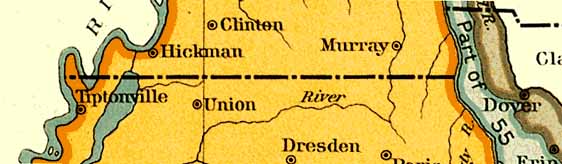
The north line of West Tennessee remained to be located on the ground. Henderson in 1821 ran it from the Tennessee to the green-timber arm of Reelfoot Lake and then to the Mississippi on the parallel of 36 degrees, 30 minutes, and 32 seconds, or about 3200 feet north of the true line. This was quite as good a result as that of Alexander and Munsell's survey in 1819, since the latter "missed the mark" on the Mississippi by 3000 feet2.
The Winchester Line
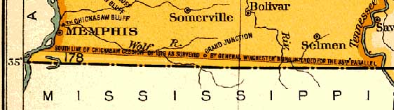
As has been seen 3 the south boundary line of West Tennessee was first officially surveyed by General James Winchester, as an official of the general government. 4 The State of Mississippi, as well as the Chickasaws, was not willing to recognize it as correct. The lower Chickasaw Bluff and young Memphis tempted the State of Mississippi to reopen the question. In January, 1829, Governor Brandon in a message to the legislature of that State urged that the line should be retraced. In 1831, the Governor reported to that body that an experimental survey by Maj. John Holland for Mississippi disclosed that the Winchester line was so nearly correct that further agitation was unnecessary. The fact was that the Winchester line was too far north; and Mississippi though to back off. But Tennessee was now the unwilling party. The surveyor, John Thompson, made a like report 5, and Governor Wm. Carroll insisted that Mississippi carry her own suggestion to the ultimate.
In January, 1837, a report to the Mississippi legislature maintained that the Winchester line was a legal one; but a commission was appointed (B.A. Ludlow, D. W. Connelly and W. Petrie) to meet commissioners in behalf of Tennessee (J. D. Graham and Austin Miller). By astronomical observations they determined that the line was so far south of that of Winchester that the domain of Tennessee was augmented by 215,927 acres 6. They marked the line from a point on the Tennessee River six chains south of the mouth of Yellow Creek to a point on the Mississippi opposite Cow Island. Their report was ratified and their line was declared the true one in the Mississippi Constitution of 1890. Recent government surveys demonstrate that this line is about one-half mile south of the true latitude. Tennessee has been fortunate in nearly all of her disputes as to State boundaries. Her chief gains, in the match of wits, have been at the expense of Virginia and Kentucky. Both the north and south boundaries of West Tennessee are thus shown to be practically those geodetical lines which were projected westward as limits for the Colonies in the earliest times.
1Chapter 67
2Not until 1859, during the administration of Gov. Isham G. Harris, was the line jointly surveyed and marked. Austin P. Cox and C. N. Briggs, for Kentucky, and Benjamin Peeples and O. R. Watkins, for Tennessee were the commissioners. They ran from the Mississippi eastward to the Tennessee. They placed markers of stone---one with a large legend on the bank of the Mississippi; others with "Ky." and "Tenn." together with the distance in miles from the starting point. Report to Governor Harris of date Nov. 11, 1869. For the calls of the survey, see Tenn.Acts of 1860.
3Chapter XIII
4Early in 1819, Col James Brown had made an unofficial survey for his own information. He began at the Tennessee and ended on March 6th practically at the point reached and fixed on the Mississippi by Gen. Winchester. Old Folks Record, 403. In this magazine, published at Memphis, Brown gives an interesting account in his "Early Reminiscences of Memphis and West Tennessee."
5Holland found Memphis to be 9 minutes, 37.7 seconds, and Thompson 9 minutes, 48.8 seconds north of the 35th degree, south of Winchester's terminus.
6At the Mississippi, the line was four and one-half miles and 514 feet south of Winchester's line.
Jillson, Willard Rouse, Sc.D Kentucky Land Grants, Vol. 1, p.11 Grants South of Walker's LineA small group of grants consisting of eight books known as the Grants South of Walker's Line are indicated in Chapter VIII. These were issued from 1825 to 1923 and consisted of 4,583 separate grants. They are located, as their title suggests, "South of Walker's Line," and north of the parallel 36 degrees and 30 minutes, a line which was accurately established in 1819 by Robert Alexander and Luke Munsell, following legislative appointment. Dr. Walker, in running his line for the southern boundary of Kentucky in 1779-80 failed to establish the true parallel of 36 degrees and 30 minutes, his line falling variously from six to ten miles north of the true parallel. Since the old Walker line had been established as the southern boundary of Kentucky and covers a considerable distance, it will be seen that the lands indicated in these grants were really in Tennessee. To settle the matter an agreement was reached in 1820 by the Commissioners selected by the states of Kentucky and Tennessee, in furtherance of which Kentucky was given the right to issue grants for all the territory lying north of parallel 36 degrees and 30 minutes and east of the Tennessee Rivers. The surveys in this system are not recorded, but are found in file boxes in the Land Office.
This page was prepared by Jane Norton Powell
Return to Obion County or Jane's Home Page
Click Here
Click Here
Thanks for dropping by.
Please visit us again.