

Colonial Period Indian Land Cessions
in the American Southeast
and Related Documents
An Overview
Part One
Page Contents.
(Links to Paragraphs)
IntroductionPart Two
The Aboriginal People of Tennessee
The Carolina Charter, 1665
Peace Treaty in Virginia, 1677
Colonial North Carolina’s Indian Policy
Shawnee, ca 1714-1715
Boys for Sale : the Business of Selling Indians
The Yamasee War, 1715
The Indian Traders
Treaty of Savannah, 1733
Treaty of Lancaster, 1744
The Land Companies
Dr. Thomas Walker’s Journal, 1750
Treaty of Logstown, 1752
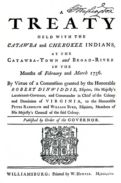
Treaty with the Catawba and Cherokee, 1756
Captain Jack and a Tennessee Land Purchase, 1757
French and Indian War, 1756-1763
Treaty of Charleston, 1761
Pontiac’s Rebellion 1763
Royal Proclamation of 1763
British Colonial Bounds with “Louisiane,” a Map
A Draugh of the Cherokee Country, 1762, a Map
North Carolina, South Carolina, Virginia, &c, a Map
Treaty of Hard Labour, 1768
Treaty of Fort Stanwix, 1768
The Six Nation Cession : Some Text from a 1778 Map
King George III & Company, 1768
Treaty of Lochaber to Tennessee Statehood
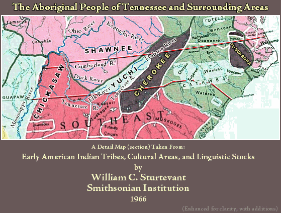
The First People of Tennessee Our Aboriginal People of Tennessee map (93k) shows the Indian cultural groups at about 1700 CE (AD) just after the beginning of the Historic Period. The map locates the Cherokee, Chickasaw, Quapaw, Shawnee, and Yuchi (a.k.a Uchee) in what is now Tennessee. We have added to our list, Catawba, Chiaha, Kaskinampo, Mosopelia, Muscogee (Creek), Natchez, Tali, and Tuskegee.
Of these First Nations, only the Cherokee and Chickasaw treated with the British colonials and/or later with the United States government to cede land in Tennessee. Spanish or French treaties with Chickasaw may exist.
Cherokee, linguistic group, Iroquian.
In historic times, East Tennessee’s major Indian Nation. (Also in western North Carolina and northern Georgia.)
In historic times, West Tennessee’s major Indian Nation. (Also in northern Mississippi and northwestern Alabama.)
The Nations (or small parts of them) listed below are believed to have either lived in within the bounds of modern Tennessee or contiguous to those bounds. Some of these Nations have treated with the United States government and have ceded non-Tennessee land. Some but not all of these Nations have simply faded away.
In historic times, the Catawba lived in the Carolinas.
“For a brief time in their later history the Catawba lived among the Cherokee and may have occupied lands in Tennessee at that time. There are indications they may have been in eastern Tennessee at a more remote epoch.”1
“A part of this tribe was encountered by De Soto in 1540, in the territory now forming this State, probably as shown by Mr. J. Y. Brame, on what is now Burns Island [South Pittsburg, Marion Cty. Tennessee]. They are also mentioned in connection with the explorations of Juan Pardo in 1567.”1
“There is every reason to believe that this tribe constituted the Casqui, Icasqui, or Casquin ‘province’ which De Soto entered immediately after crossing the Mississippi River, and it was probably in what is now Phillips County, Ark. We hear of the Kaskinampo next in connection with the expeditions of Marquette and Joliet but do not learn of their exact location until 1701, when they seem to have been on the lower end of present Pine Island. We are informed, however, by one of the French explorers that they had previously lived upon Cumberland River, and there is evidence that when they first moved to the Tennessee, they may have settled for a short time near its mouth. Both the Cumberland and the Tennessee were known by their name, and it stuck persistently to the latter years of the eighteenth century. After the early years of the eighteenth century we hear little more of them, but there is reason to believe that they united with the Koasati.”1
“This tribe probably established themselves on Cumberland River and at one or two points on the Tennessee shore of the Mississippi on their way from Ohio to Mississippi.”1
A northern Georgia Nation whom Ramsey reported as having a slight presence on the Tennessee River as far north the mouth of the Hiwassee River.
Then we see ...
“Although we do not have records of any settlements in Tennessee by the true Muskogee, it is probable that some of them occupied part of its territory in prehistoric times, and at a later date their war parties constantly visited it.”1
In 1729, the pro-Chickasaw Natchez massacred the French people of Fort Rosalie (located at present day Natchez Mississippi). Soon after, a French-Choctaw force destroyed the Natchez people. Many Natchez were killed; some were enslaved and sent to the West Indies. Some Natchez were able to flee and joined other tribes. “After being driven from Mississippi and Louisiana, one band of Natchez lived among the Cherokee.”1
Originally from the Ohio Valley. By 1667, they were forced from their homelands by the Iroquois League. They settled at the mouth of the Arkansas River. There influence on the east side of the Mississippi was minimal.
See below.
“A tribe met by De Soto near the great bend of the Tennessee and found in the same region by the earliest English and French explorers, living in what is now northern Alabama and perhaps also in Tennessee. It is probable that they were a part of the Creeks.”1
In historic times, the Tuskegee lived in Alabama.
“One band of Tuskegee formed a settlement or settlements in the Cherokee Nation.”1
“The later and best know location of this tribe was on the point of land between Coosa and Tallapoosa Rivers, but in 1685 part of them were on the Chattahoochie River near modern Columbus [Alabama] and the rest were on the upper Tennessee near Long Island [Long Island is on the Tennessee Georgia line].”2
Please visit our Yuchi Page. For our purposes, the Historic Period for Tennessee’s Indian Nations is the period covered by the white man’s written records. Before that, there were hundereds of generations of Indians living in Tennessee. Stepping back in time to the Prehistoric Period, we find the mound builder societies; there were the Mississippian (800 CE to 1450 CE) and Hopewell (100 BCE to 400 CE) cultures in Tennessee. Today, archeological work is conducted at many of these sites. All are part of the story of the First People of Tennessee.
_______
1. The Indian Tribes of North America, by John R. Swanton. Smithsonian Institution, Bureau of American Ethnology. Bulletin 145. Government Printing Office, 1953; pp. 215-229.
2. Ibid, p. 172.
The King’s charter for the Proprietorship of Carolina in effect gave Carolina (later North Carolina) the land that was to become Tennessee. The Charter specified Carolina’s boundary as:
“. . . All that Province, Territory, or Tract of ground, situate, lying, and being within our Dominions of America aforesaid, extending North and Eastward as far as the North end of Carahtuke River or Gullet; upon a straight Westerly line to Wyonoake Creek, which lies within or about the degrees of thirty six and thirty Minutes [36° 30'], Northern latitude, and so West in a direct line as far as the South Seas; and South and Westward as far as the degrees of twenty nine, inclusive, northern latitude; and so West in a direct line as far as the South Seas . . .”
ARTICLES OF PEACE BETWEEN CHARLES II AND SEVERAL INDIAN KINGS AND QUEENS CONCLUDED THE 29TH DAY OF MAY, 1677.
SYNOPSIS. The treaty consists of 21 articles, in which the Indians acknowledge subjection to the British Crown and the British guarantee them protection. They provide that no English settlement shall be made nearer than three miles of any Indian town and that the Indians shall be "secured and defended in their persons, goods and properties against all hurts and injuries of the English." They are also to be protected in their "Oystering Fishing and gathering of Tuchahoe Curtenemons Wild Oats Rushes buckoone or any thing else."
The treaty was signed by the Queen of Pamunkey, Queen of Waonoke, King of the Nancymond Indians, King of the Nottoways and Captain John West, Son of the Queen of Pamunkey, and their marks or totems are reproduced in facsimile, on p. 16.
_____
A Bibliography of the English Colonial Treaties with the American Indians ... By Henry Farr De Puy, 1917
_____
(Historically, the Pamunkey nation inhabited the coastal tidewater of Virginia on the north side of the James River near Chesapeake Bay. The Pamunkey is one of only two tribes that still retain reservation lands assigned by the 1646 and 1677 treaties with the English colonial government.)
“History does not make clear the policy of the North Carolina colony in dealing with the Indians in regards to their lands; it does not appear that any official policy was adopted until the near the close of its colonial existence . . .
“. . . the relations existing between the settlers and natives were friendly and peaceful up to the year 1711 . . . After the conquest of the Tuskarora there was no other tribe, except the Cherokee, on the their western frontier which the colonists deemed worthy of consideration . . .
“It would seem . . . that but a comparatively small portion of the territory of North Carolina was purchased from the Indians . . . Mr. James Mooney, of the Bureau of American Ethnology, who has made a careful study of the natives of the section, remarks- _____The tribes of between the mountains and the sea were but of small importance politically; no sustained mission work was ever attempted among them, and there were but few literary men to take an interest in them. War, pestilence, whisky and systematic slave hunts had nearly exterminated the aboriginal occupants of the Carolinas before anybody thought them of sufficient importance to ask who they were, how they lived, or what were their beliefs and opinions.
. . .”
From : Indian Land Cessions in the United States, Compiled by Charles C. Royce. The 18th Annual Report of the Bureau of American Ethnology -- 1896-’97, Vol II, p 624-630.
Full text, pp. 624-630.
The Shawnee (Shawano, Shawanese, Shawanoe, etc.) originally inhabited southern Ohio, West Virginia, and western Pennsylvania. The Shawnee were driven from this area by the Iroquois League sometime in the 1660s. They settled in South Carolina, Tennessee’s Cumberland River Basin, eastern Pennsylvania, and southern Illinois. After Shawnee raids on the Cherokee, the Cherokee entered into an alliance with the Chickasaw about 1714, and together, they drove the Shawnee from the Tennessee and Cumberland River basins in Tennessee and Kentucky. The Shawnee had an inclination to settle on the lower Cumberland River. They were forced northward beyond the Ohio River. Afterward, if the Chickasaw found the Shawnee upon “Chickasaw land,” the Shawnee would be eliminated.
The removal of the Shawnee from Middle Tennessee would give both Cherokee and Chickasaw the right to claim that land as their own. There then would be a dual claim for the same land, based on the right of conquest.
By 1730, the Shawnee was no longer part of Tennessee’s direct history, however they were fierce warriors and they made the frontier settlers tremble, especially during the French and Indian War.
During the late 1600s into the early 1700s, English traders from the Virginia and Carolina colonies conducted a thriving business of buying, branding, and selling young Indian slaves. One source was to raid the Catholic Missions that that had been established to Christianize the Indians on the Spanish Florida-Georgia frontier. We see Christian neophytes being kidnapped, and later sold. Many Indian Nations were in the slave selling business, including the Cherokee and the Creek. Some claim English traders in the Carolinas seized between 10,000 and 12,000 mission Indians who had been part of the Spanish mission system and sold them into slavery in the West Indies.
The Yamasee was a tribe of Muskhogean stock, residing formerly near the Savannah River and in Florida. The Spanish missionaries under Fray Antonio Sedeño began to labor among them about 1570, and little trouble arose until a rebellion of the Yamasee was provoked by an attempt of the Spanish civil authorities to send some of them to the West Indies and into slavery. Many of the Indians fled to English territory in South Carolina and settled there. In Carolina on the 15th of April, 1715, the Yamasee War began. It involved the Apalachee, Creek, Sarraw, Savannah, and Yamasee against the white traders and settlers.
There had developed an extensive trade in deer hides; the Indians used those hides as their currency for trade for European goods. While the Indians became indebted to the traders, their ability to pay diminished as they depleted their source. Competition from increasing numbers of white trappers only made matters worse. The Yamasee had also complained of the traders enslaving their women and children, however, the Carolina authorities were helpless in remedying the ever worsening situation. The war began with an attack on the white traders in Indian towns. The extortion and cruelty of the English traders drove them to take up arms, and a general massacre of white settlers took place.
In June, Carolina forces under Governor Craven defeated the Yamasee at Salkiehatchen and driven back into Florida, where they allied themselves with the Spaniards. The Yamasee captives of the English colonists were shipped to the slave markets in the West Indies. Escaping Yamasee fled south into Spanish Florida. There the Yamasee and Lower Creek continued the struggle along the border. In Carolina, the Upper Creek also continued their attack, almost taking Charles Town.
The Cherokee, a traditional enemy of the Creek, had been at the periphery of this war. When asked by the Creek to help them, the Cherokee instead sided with the British, thus weakening the Creek position.
In 1717, a peace treaty was reached, however this war revealed just how vulnerable Carolina was to the pressures and threats of their Spanish and French neighbors on the other side of the Colony’s southern and western borders.
In 1727 the English destroyed the Yamasee village near St. Augustine and massacred most of them. They were finally incorporated with the Seminole and Hitchiti, although a small body still preserved the name in 1812. The Yamasee have now disappeared.
_____
Some of the data in “The Yamasee War, 1715” from: The Catholic Encyclopedia, Volume XV, © Robert Appleton Company, 1912.
Suggested reading: The Indian Slave Trade: The Rise of the English Empire in the American South, 1670-1717, by Alan Gallay, 2002
“Pioneers of the Old Southwest”1
Chapter III
The Trader
(Excerpt)
“The trader was the first pathfinder.2 His caravans began the change of purpose that that was to come to be the Indian warrior’s route, turning it slowly into the beaten track of communication and commerce. The settlers, the rangers, the surveyors, went westward over the trails which he had blazed for them tears before. Their enduring works are commemorated in the cities and farms which today lie along every ancient border line; but of their forerunner’s hazardous Indian trade nothing remains. Let us therefore pay a moment’s homage here to the trader, who first --- to borrow a phrase from Indian speech --- made white for peace the red trails of war.
He was the first cattleman of the Old Southwest. Fifty years before John Findlay, one of this class of pioneers, led Daniel Boone through the Cumberland Gap, the trader’s bands of horses roamed the western slopes of the Appalachian Mountains and his cattle grazes among the deer on the green banks of the old Cherokee (Tennessee) River. He was the pioneer settler beyond the high hills; for he built in the center of the Indian towns, the first white man’s cabin --- with its larger annex, the trading house --- and dwelt there during the greater part of the year. He was America’s first magnate of international commerce. His furs --- for which he had paid in guns, knives, ammunition, vermilion paint, mirrors, and cloth --- lined king’s mantels, and hatted the Lords of Trade3 as they strode to their council chamber in London to discuss his business and to pass on those regulations which might have seriously hampered him but for his resourcefulness in circumventing them.
He was the first frontier warrior, for he either fought off or fell before small parties of hostile Indians who, in the interest of the Spanish or French, 4 raider his pack-horse caravans on the march. Often, too, side by side with his red brothers of his adoption, 5 he fought the in the intertribal wars ...”
_____
1. From : Pioneers of the Old Southwest, a Chronicle of the Dark and Bloody Ground; by Constance Lindsay Skinner, 1919, Yale University Press, pp. 52-53.
2. The first Carolina trader among the Chickasaw was Thoms Welch, as early as 1698; English traders, Virginians or Carolinians, were reported by the French to be among the Overhill Cherokee at least four years earlier. (From: Annals of Tennessee, by J. G. M. Ramsey, 1853, East Tennessee Historical Society edition, 1967, annotation section, by Stanley Folmsbee, p. 750.)
3. The European demand for furs was gigantic. Between 1700 and 1715, i.e., one million deer hides were shipped through the Port of Charles Town (Charleston) alone. Competition from white hunters also hurried the depletion these resources. As more animals were taken, this caused an environmental impact which forced Indians to hunt farther from home. The Indians became accustomed to the trade goods, and in time, became indebted for those trade goods. In the end, they could only pay their debts with their land.
4. “Jean du Charleville, who was a youthful assistant of an anonymous trader who had established a trading post at ‘French Lick’ on the Cumberland about 1710 ... Those traders were preceded in the Tennessee Country by two French renegades, Martin Chartier on the Cumberland in 1689, and Jean Couture on the Tennessee by 1696.”
(From: Annals of Tennessee, by J. G. M. Ramsey, 1853, East Tennessee Historical Society edition, 1967, annotation section, by Stanley Folmsbee, p. 750.)
5. The traders were the first to penetrate Indian Country. They were white men living on the edge of civilization, or in some cases, living among the Indians, and very often taking an Indian wife. Some became almost Indian but only a few left records. One who left much was James Adair, the “English Chickasaw” who wrote Adair’s History of the American Indians.” London 1775.
Indian Traders on Muscle Shoals of the Tennessee River1
“Two Hundred Years at Muscle Shoals”
(Excerpt)
“Both the French and the English contended for the Indian trade along the western waters; the French planted a post at Muscle Shoals before 1715. Because of the increasing importance of trade with the whites the Cherokee planted villages near Muscle Shoals area in the last quarter of the eighteenth century ... Oka Kapassa was established about 1770 ... about one mile west of present Tuscumbia ... This site was resorted to by neighboring Indians for the purpose of trading with the French who still persisted on the Wabash [river, after the French and Indian War], and became the source of great vexation and numerous outrages to the Cumberland settlements about our present Nashville. After the murder of his brother by plunderers from Oka Passa, Col. James Robertson resolved on the destruction of the Indian village ... In the latter part of 1787, Col. Robertson with a volunteer force of about 130 men and two Chickasaw Indians as guides ... fell upon the town ... Twenty-six Indians were killed; three French traders and a white woman met a similar fate ... sent the six remaining French traders away with a division of the goods taken--the goods consisted of ‘stores of tafia,2 sugar, coffee, cloth, blankets, knives, powder, tomahawks, tobacco, and other articles suitable to Indian commerce’ ... ”
_____
1. From: Two Hundred Years at Muscle Shoals, by Nina Leftwich Tuscumbia Alabama, 1935, pp. 12 &c 13.
2. Tafia, a crude and violent rum drink, the pirates employed it to disinfect wounds, cure migraines, lend courage in battle and celebrate after a victorious raid. They carried this firewater to all the ports of the Caribbean. Apparently, some Tafia also found its way to Oka Passa.
Treaty at Lancaster Pennsylvania, between British colonies of Virginia, Maryland, and Pennsylvania and the Iroquois nations of Oneida, Onondaga, Cayuga and Seneca.
This Journal in many ways was a sign of things to come. First came the “Indian” traders, white men living on the edge of civilization, trading with the Indians for furs (and often marrying Indian women). Then came the explorers, like Dr. Thomas Walker, followed by illegal settlers and wars with the Indians, then forced treaties, and finally, waves of legal settlers.
Dr. Walker headed the Loyal Land Company from 1752 and through the last half of his life, his activities involving land could earn him the title of “Grand Land Speculator.” He is sometime credited with discovering the Cumberland Gap. He did name the river for the Duke of Cumberland, and later the name Cumberland was applied to Cave Gap. However he certainly was not the first white person to go through the gap. In 1673, Gabriel Arthur traveled through the gap with the Cherokee or perhaps the Yuchi.
Walker was also involved Treaty of Lochaber, 1770, and with that strange 1771 “addition” to that Treaty. And of course, there is the so called “Walker Line,” the long northern 1779-‘80 Tennessee state line survey that both Thomas Walker and Richard Henderson managed to get wrong.
_____
(Journal from our Land of Our Ancestors project.)
The Virginians treated with Ohio Indians at Logstown and got confirmation from the Mingos of the Treaty of Lancaster in 1744. The Delaware and Iroquois Indians acknowledge the Virginia colony’s claim to territory south of the Ohio River. The English were allowed to form settlements on the south and east side of the Ohio. The Iroquois signed the Logstown Treaty confirming their land cessions in 1744 and gave the British permission to build a blockhouse at the forks of the Ohio (site of future Pittsburgh). The French destroyed this fort before it was completed and then proceeded to build Fort Duquesne at the same location.
SYNOPSIS. Treaty Held in February and March, 1756, Between the Governor of Virginia and the Catawba and Cherokee Indians.
The treaty with the Catawbas was held at Catawba town, February 20 and 21, 1756, and that with the Cherokees, March 13 to 17, 1756, at Broad River. To both tribes Governor Dunwiddie sent speeches by his Commissioners Peter Randolph and William Byrd. The speeches are printed. The Indians are reproached for some perfidious actions but a treaty is made by which both tribes are to fight against the French.
_____
A Bibliography of the English Colonial Treaties with the American Indians ... By Henry Farr De Puy, 1917
“In 1762 a grant to one Captain Patrick Jack was signed by [North Carolina] Governor [Arthur] Dobbs and Little Carpenter for certain lands in eastern Tennessee, which seems had been purchased by Jack of the Cherokee in 1757.”
_____
From : Indian Land Cessions in the United States, Compiled by Charles C. Royce. The 18th Annual Report of the Bureau of American Ethnology -- 1896-’97, Vol II, p 629.
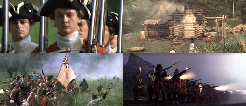
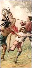
Scenes from the film THE LAST OF THE MOHICANS
In the early part of the 1700s, the Trans-Appalachian region of North America was Indian Country. Some British colonial trappers, backwoodsmen, and traders penetrated that country, as did their French counterparts. As the British colonial population grew, the allure of western land for settlement meant the land to the west of the Appalachian mountains became their objective.
The French claimed the entire watersheds of the Mississippi and St. Lawrence Rivers, including the Ohio Valley. As the French became concerned about British intrusions into this region, they created a number of forts to protect their interests. The British, meanwhile, also built their own forts, and the British granted lands in the Ohio Valley to the Ohio Company.
In 1754, the conflict between Britain and France became a real war on the British colonies’ western frontier, when George Washington launched a strike against a French camp. This was the first engagement of the yet undeclared French & Indian War, with the official declaration occurring in 1756.
This war struck settlers all across the Appalachian frontier. The French set their Indian allies against the outlying farmsteads. On 18 June 1755 the Shawnee killed Samuel Stalnaker’s wife and also their son Adam, and then the Shawnee took Samuel as a captive (Samuel Stalnaker was the man Dr. Thomas Walker mentioned in his Journal, the Indian trader who gave Dr. Walker directions to Cave Gap). On 30 July 1755, the Shawnee Indians wiped out the New River Settlement in Virginia. At that Draper’s Meadows massacre, Mary Draper Ingles, the wife of William Ingles, and her small son Thomas were taken captive by the Indians. Mrs. Ingles made her escape in the late fall of that year. This story one is of the classic “survivor” stories of the French and Indian War.
William Pitt, Britain’s prime minister, had adopted a policy of greatly increasing aid to the American colonies, and he was able to do so because the Royal Navy kept the sea-lanes open. With supplies assured and the use regular line soliders, by 1758, the British began gaining important victories. By 1761, French resistance in North America had virtually ceased. Fighting continued only in the south between British and the Cherokee Indians, and that ended in a British victory in 1761.
Ultimately, the British won the war, and with the Treaty of Paris, 10 February 1763, all of North America east of the Mississippi, other than New Orleans, was ceded to the British. Out of the conquered territory England created three new provinces: in Canada the Province of Quebec; out of the country conquered from Spain, two provinces, namely, East Florida and West Florida. The Appalachicola separated the Floridas. The land between the Altamaha River and the St. Mary’s was annexed to the Province of Georgia. France then ceded New Orleans and the lands west of the Mississippi to Spain.
The Indians who fought with the French did so to stop the westward push of the settlers. When the war ended, many Indians still continued to see the British and the colonial settlers as a threat so the Indians continued to fight them. In the summer of 1763, Pontiac, an Ottawa chief, led raids on frontier British forts.
On 9 May, Pontiac lays siege to Fort Detroit with a force composed of Ottawas, Chippawa, Potawatomi, Huron, Shawnee, and Delaware warriors. Indians near Detroit move east in force Tribal allies destroy forts at Venango, LeBoeuf, and Presque Isle. Senecas wipe out a convoy near Niagara. Shawnee chief Keigh-tugh-qua, or Cornstalk, led attacks on western Virginia settlements.
By the end of July, Indians had captured all British forts west of the Alleghenies except Detroit, Fort Pitt, and Fort Niagara. In July. the besieged garrison at Fort Pitt stared an epidemic among the Indians by infecting chiefs with blankets from the smallpox hospital. On 1 August, the Indians withdraw from siege of Fort Pitt. Then, on 6 August 1763, British forces, Colonel Henry Bouquet commanding, retaliated and destroyed Delaware and Shawnee forces at Bushy Run in western Pennsylvania, ending the hostilities.
In order to keep peace between the Indians and settlers, King George III issued the Royal Proclamation of 1763, prohibiting settlement west of the Allegheny Mountains.
On 7 October 1763, King George III signed the Royal Proclamation of 1763 that established a boundary line from Canada to Florida west of which white settlement was prohibited. A boundary line ran approximately along the Appalachian ridge (watershed divide). All land drained by the Mississippi watershed was reserved for Indians, while those lands that drained into the Atlantic Ocean were reserved for white settlement (the Colonies).
Therefore, most of the land gained from the French in the recently concluded French and Indian War was closed to the white settlers.
Excerpts from:
Royal Proclamation of 1763
King George III, 7 October 1763
[The Indian Provisions]
“ . . .
And whereas it is just and reasonable, and essential to our Interest, and the Security of our Colonies, that the several Nations or Tribes of Indians with whom We are connected, and who live under our Protection, should not be molested or disturbed in the Possession of such Parts of Our Dominions and Territories as, not having been ceded to or purchased by Us, are reserved to them, or any of them, as their Hunting Grounds -- We do therefore, with the Advice of our Privy Council, declare it to be our Royal Will and Pleasure, that no Governor or Commander in Chief in any of our Colonies of Quebec, East Florida. or West Florida, do presume, upon any Pretence whatever, to grant Warrants of Survey, or pass any Patents for Lands beyond the Bounds of their respective Governments. as described in their Commissions: as also that no Governor or Commander in Chief in any of our other Colonies or Plantations in America do presume for the present, and until our further Pleasure be known, to grant Warrants of Survey, or pass Patents for any Lands beyond the Heads or Sources of any of the Rivers which fall into the Atlantic Ocean from the West and North West, or upon any Lands whatever, which, not having been ceded to or purchased by Us as aforesaid, are reserved to the said Indians, or any of them.
And We do further declare it to be Our Royal Will and Pleasure, for the present as aforesaid, to reserve under our Sovereignty, Protection, and Dominion, for the use of the said Indians, all the Lands and Territories not included within the Limits of Our said Three new Governments, or within the Limits of the Territory granted to the Hudson’s Bay Company, as also all the Lands and Territories lying to the Westward of the Sources of the Rivers which fall into the Sea from the West and North West as aforesaid.
And We do hereby strictly forbid, on Pain of our Displeasure, all our loving Subjects from making any Purchases or Settlements whatever, or taking Possession of any of the Lands above reserved, without our especial leave and Licence for that Purpose first obtained.
And We do further strictly enjoin and require all Persons whatever who have either wilfully or inadvertently seated themselves upon any Lands within the Countries above described or upon any other Lands which, not having been ceded to or purchased by Us, are still reserved to the said Indians as aforesaid, forthwith to remove themselves from such Settlements.
And whereas great Frauds and Abuses have been committed in purchasing Lands of the Indians, to the great Prejudice of our Interests. and to the great Dissatisfaction of the said Indians: In order, therefore, to prevent such Irregularities for the future, and to the end that the Indians may be convinced of our Justice and determined Resolution to remove all reasonable Cause of Discontent, We do, with the Advice of our Privy Council strictly enjoin and require, that no private Person do presume to make any purchase from the said Indians of any Lands reserved to the said Indians, within those parts of our Colonies where We have thought proper to allow Settlement: but that, if at any Time any of the Said Indians should be inclined to dispose of the said Lands, the same shall be Purchased only for Us, in our Name, at some public Meeting or Assembly of the said Indians, to be held for that Purpose by the Governor or Commander in Chief of our Colony respectively within which they shall lie: and in case they shall lie within the limits of any. Proprietary Government, they shall be purchased only for the Use and in the name of such Proprietaries, conformable to such Directions and Instructions as We or they shall think proper to give for that Purpose: And we do, by the Advice of our Privy Council, declare and enjoin, that the. Trade with the said Indians shall be free and open to all our Subjects whatever, provided that every Person who may incline to Trade with the said Indians do take out a Licence for carrying on such Trade from the Governor or Commander in Chief of any of our Colonies respectively where such Person shall reside, and also give Security to observe such Regulations as We shall at any Time think fit, by ourselves or by our Commissaries to be appointed for this Purpose, to direct and appoint for the Benefit of the said Trade:
And we do hereby authorize, enjoin, and require the Governors and Commanders in Chief of all our Colonies respectively, as well those under Our immediate Government as those under the Government and Direction of Proprietaries, to grant such Licences without Fee or Reward, taking especial Care to insert therein a Condition, that such Licence shall be void, and the Security forfeited in case the Person to whom the same is granted shall refuse or neglect to observe such Regulations as We shall think proper to prescribe as aforesaid.
And we do further expressly conjoin and require all Officers whatever, as well Military as those Employed in the Management and Direction of Indian Affairs, within the Territories reserved as aforesaid for the use of the said Indians, to seize and apprehend all Persons whatever, who standing charged with Treason, Misprisions of Treason, Murders, or other Felonies or Misdemeanors, shall fly from Justice and take Refuge in the said Territory, and to send them under a proper guard to the Colony where the Crime was committed, of which they stand accused, in order to take their Trial for the same.
Given at our Court at St. James’s the 7th Day of October 1763, in the Third Year of our Reign.
GOD SAVE THE KING”
This is a section of a French map which shows how the bounds of these colonies appeared just before the end of the French and Indian War. Although the map is dated 1783, the information appears to be from about twenty years earlier. Shown is “Louisiane” on both sides of the Mississippi River, a separate “Flordie“ and the British colonies. The western boundaries of the colonies would be the line that limited westward expansion by the Royal Proclamation of 1763. The map title is “Carte generale des États Unis de l’Amerique Septentrionale.”
Source : Library of Congress, American Memory, Map Collections, 1500-1999
Source : Tennessee State Library and Archives, Nashville TN. Our copy came to us as a discarded blueprint and our image has been “color reversed” and adjusted. It appears that the original map may have been drawn in 1856 from 1762 notes. Also note that “East” would be at the Top : : of the map.
This Map shows how the bounds of these colonies appeared just after the French and Indian War.
Source : Library of Congress, American Memory, Map Collections, 1500-1999
Treaty of Hard Labour (South Carolina). 14 Oct 1768. Treaty with the Cherokee.
Cherokee Northern Boundaries Defined
. . . Mr. Stuart, the Superintendent of Southern Indian Affairs, was therefore instructed to assemble the southern Indians for the purpose of establishing a boundary with them; and before negotiation with the confederates as Fort Stanwix had begun, he concluded a treaty with the Cherokees at Hard Labour, in South Carolina, October 14, 1768, By this treaty, it was agreed that the south-western boundary of Virginia should be a line “extending from the point where the northern line of North Carolina intersects the Cherokee hunting grounds, about thirty-six miles east of Long Island, in the Holston river, and thence extending in a direct course, north by east to Chiswell’s Mine, on the east bank of the Kenhawa river, and thence down that stream to its junction with the Ohio.” This line however, did not include all the settlements then made; and even during the progress of the treaty, the settlers were advancing further west, and erecting their cabins north-west of the Holston, and upon the branches of the Clinch and Powell’s river, within the limits of the Indian territory. This fact being ascertained, a subsequent treaty became necessary for the adjustment of a new boundary and the remuneration of the savages for an additional extent of country. *
*Monette. _____
From : The Annals of Tennessee to the End of the Eighteenth Century. 1853. Dr. J. G. M. Ramsey. pp 76-77
Treaty of Fort Stanwix (now Utica, New York). 5 Nov 1768. Treaty with the Six Nations, with cessions to the King of England.
Tennessee’s First Cession from Aboriginal Owners
. . . Three thousand, two hundred Indians, of seventeen tribes, tributaries to the Confederacy, or occupying territories coterminous with theirs attended. On the 5th of November, a treaty of limits and a deed of cession to the King of England, were signed. In this, the delegates of their respective nations aver that“they are the true and absolute proprietors of the lands thus ceded,” and that for the considerations mentioned, “we have continued the line south to the Cherokee or Hogohegee rivers,* because the same is, and we declare it to be, our true bounds with the Southern Indians, and that we have an undoubted right to the country as far south as that river.
The cession thus made by the Six Nations,** of the country north and east of the Tennessee river, is the first deed from any aboriginal tribes for any territory within the boundaries of our state [Tennessee]. . .
*The Holston was thus called. _____
From : The Annals of Tennessee to the End of the Eighteenth Century. 1853. Dr. J. G. M. Ramsey. pp 75-76
_____
** The Six Nations (Iroquois Confederation) were composed of the Mohawks, Oneidas, Onondagas, Cayugas, and Senecas (the original five tribes of the Iroquois Confederation --- all were New York area tribes), plus a sixth tribe, the Tuscaroras, who moved from the North Carolina area to the Pennsylvania-New York area after 1712, later joining the Iroquois Confederation.
F.S.
The Six Nation Cession:
Some Text From a 1778 Map
All the Country comprehended between the Western and Southern Boundaries of the Province of Pennsylvania and extending Southward (on the Eastern Side of the River Ohio) to the Mouth of the Cherokee [Tennessee] River and Thence from every part of its Front on the River Ohio to the Allegany Mountains (except that part of the Country called Indiana*) was granted by the Six United Nations of Indians to his Majesty for the Sum of £10.460.73 Sterling as by their Deed bearing Date at Fort Stanwix in the Province of New York, on the 5th day of Novem. 1768
_____
From : A new map of the western parts of Virginia, Pennsylvania, Maryland, and North Carolina; comprehending the River Ohio, and all the Rivers which fall into it; Part of the River Mississippi, the Whole of the Illinois River, Lake Erie, Part of the Lakes Huron, Michigan &c. And all the Country bordering on these Lakes and Rivers.
By Thos Hutchins
Captain in the 60 Regiment of Foot.
London, Published according to Act of Parliament Novembr 1st 1778
Source : Library of Congress, American Memory, Map Collections, 1500-1999
_____
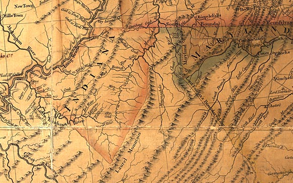
* “Indiana” (Indiana Land Company) appears on the 1778 map as a tract south of the River Ohio and would now be in present day West Virginia, northeast of the Little Kanawa River. See Image.
F.S.
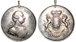
King George III Indian Peace Medal
The Royal Proclamation of 1763 was never popular with the American colonists, so after the 1768 Indian treaties of Hard Labour and Fort Stanwix, the British Government agreed to move the Proclamation Line westward into the region of the upper Ohio River. This appeased the land speculators, both Americans and British. However, the Virginia and North Carolina colonists were never satisfied with the official British land and Indian policies. It was believed that removal of British authority would allow great westward expansion of white settlement and therefore, great profit for the land companies. American dissatisfaction with the Royal Proclamation was one of the more serious reasons that lead to the Revolutionary War. The southern settlers’ eyes were turning westward and they liked what they saw. 
Great Smoky Mountains
Scene from the film THE LAST OF THE MOHICANS
The Last of the Mohicans
Based on the book by James Fenimore Cooper, the film The Last of the Mohicans, is one of the best and most beautiful period films ever made. The story includes the siege at Fort William Henry (1757) during the French and Indian War. The Fort was located on Lake George (New York) or as the French called it, Lac Du St. Sacrement. Recent archeological studies at the fort have uncovered much information of the siege. The film itself was photographed not in New York state, but in western North Carolina -- in what had been Cherokee Country. Visit the Mohican Press website and enjoy the efforts of two folk who pay reverence to the film and the Mohicans.
Colonial Period Indian Land Cessions In Tennessee, Part Two
Treaty of Lochaber to Tennessee Statehood
Indian Land Cessions
Home Page
This page last updated on
Page © Copyright 2001-present, TNGenNet Inc