Henderson Co. TN
Mr. Jonathan Kennon Thompson Smith of Jackson has published seven genealogical miscellanies for Henderson County. He wishes to share this information as widely as possible and has granted permission for these web pages to be created. We thank Mr. Smith for his generosity. Copyright, Jonathan K. T. Smith, 2001
In 1782 the North Carolina legislature set aside a military reservation in what is now upper middle Tennessee. Land grants were made there for Revolutionary War veterans as compensation for their military services. When he had served out his enlistment, a soldier was issued a certificate testifying to his service and honorable discharge or he had to wait and make claim for his service years after the war. He could be rewarded with a grant of land in the western territories. The amount of acreage alloted was determined by military rank.
According to the Land Act of 1782 no claims could be entered before October 20, 1783. Within a few months astute eastern land speculators had sent out surveyors to lay off the best land for themselves, buying military warrants from veterans to convert into land claims for themselves. An entry had to be made for the amount of land due the claimant and the survey with a plat drawn. It then was submitted to the secretary of state of North Carolina who was authorized to issue a grant after it received the signature of the governor. The land office closed in Hillsboro, North Carolina in May of 1784 after operating only seven months during which some four million acres of Tennessee land had been processed.
Even after North Carolina had ceded its western territory to the national government in 1790 the state retained the right to satisfy land grants for military service there. Then in 1796, when Tennessee was admitted into the union, the two states agreed to work together in settling land claims. Although the Chickasaw Indians had more or less agreed to relinquish their claim to land in middle Tennessee, James Robertson and Silas Dinsmoor signed a treaty of cession in July of 1805 with them for the east and north sections of the Congressional Reservation. In April of 1806 the United States agreed to turn over jurisdiction of all land grants to the state of Tennessee.
An important provision of the federal legislation of 1806 regarding the Congressional Reservation was that there should be insufficient land in that reservation then the land south and west of it could be entered. This country became known as the Western District. The United States laid claim to all land east of the Mississippi River based on the Royal Charter of 1663 when the English monarch placed theoretical claim to the eastern and transmontane lands in the south. However, in reality the state and national governments treated with the various Indian tribes for this vast domain.
In 1806 Tennessee established two land offices, one with headquarters in Knoxville for east Tennessee and one in Nashville for west (now middle) Tennessee. Each office was supervised by a register who was qualified by law to issue land grants.
Acting in the interest of the United States the governments of Tennessee and North Carolina and commissioners Andrew Jackson and Isaac Shelby made a treaty of cession with the Chickasaws for all their lands in west Tennessee and western Kentucky. Naturally, this was followed by authorization by Congress in April of 1818 for Tennessee, rather than North Carolina, to "issue grants and perfect titles to land south and west of the Congressional line in settlement of these claims."
The cession called the Jackson Purchase by many persons was made on October 19, 1818 and thus was west Tennessee ceded to the "whites." The treaty of cession was accepted by the national government and ratified when it was signed by President James Monroe on January 7, 1819. The Tennessee legislature convened in October of that year and accepted the cession, expressed its intention of honoring old North Carolina land grants and established land offices to distribute the land effectively.
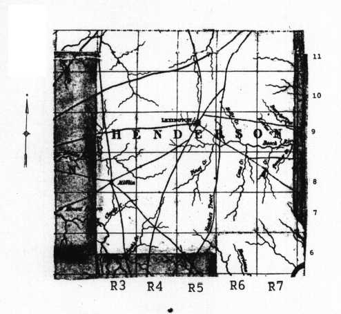
On October 23, 1819 the state legislature divided the Western District into seven surveyor districts. These were then divided into ranges that ran north and south in five mile squares called sections. HENDERSON COUNTY was located in Surveyor District 9. Until the county was created late in 1821 the persons living in what is now Henderson County were included in the domain of Stewart County as was most of what is now west Tennessee. Hence, the first land grants involving Henderson County often bore the name of Stewart County as the place within which the lands involved were located. Colonel John Purdy was the principal surveyor of the 9th Surveyor District with an office at first in what is now Lexington and soon removed to his own home-place near Mifflin.
For an individual to acquire public land legally by gaining a title he first had to secure a warrant or certificate from a land register or land commissioner for that specific acreage or else buy the warrants of others for land. Then he had to locate his land as a warrant just stipulated the amount of acreage involved not its location; after which it was entered upon an entrybook kept by an official entry-taker who could record this entry so that it might then be laid out by an official surveyor. Colonel Purdy had numerous deputy surveyors who actually surveyed these many plots. This process completed, the claimant then submitted survey and plot to the secretary of state of Tennessee who issued a land grant for the land, attaching a permanent number to the land grant and thereby preventing duplications of numbers and overlapping of some land grants.
Unfortunately the land entry and land survey records of Surveyor District 9 were evidently destroyed when the Henderson County courthouse was burned to a great extent in May 1863 or in July 1895 when a more destructive fire destroyed the county courthouse. Even so, all lands perfected to land grant status are known because the state land grant records have survived. The General Land Grants involving Henderson County were recorded, starting with General Land Grant Book T.
HENDERSON COUNTY, TENNESSEE
Surveyor District Nine
"Map of Tennessee" by Matthew Rhea, Philadelphia 1832
The present writer has attempted to abstract all the Henderson County land grants in the earliest general land grant books. In the following abstracts the page of the land grant book on which the land grant was recorded is given, followed by the land grant number, the grantee's name, the acreage, the date the land was entered, the date the land was surveyed and then the date of the actual land grant; followed by Surveyor District 9 (SD 9), the range (R) and the section (S). In the grants the county involved was sometimes given as Stewart County as that was the "parent county" for those living in Henderson County, and other west Tennessee counties as well before they were created by the state legislature and organized; Henderson County was created in November 1821 and some lands were in the granting process before and through that date.
page 37, #16918, SAMUEL WILSON, 726 acres, February 6,1821, December 28,1821, April 12,1822, SD 9, R 5, S 9.
page 121, #16924, SAMUEL MOORE, 130 acres, August 21, 1821, August 22, 1821, April 12, 1822; SD 9, R 3, S 11.
page 205, #16976, SAMUEL WILSON, 230 acres (reference made to NE corner of entry 463 for 726 acres in Wilson's name), February 6, 1821, December 28, 1821, April 16, 1822, SD 9, R 5, S 9.
page 335, #17392, SOLOMON ROZELL, 274 acres, December 22, 1820, October 12, 1821, June 11, 1822, SD 9, R 5, S 10.
page 336, #17394, SOLOMON ROZELL, 50 acres, October 4, 1821, October 11, 1821, June 11, 1822, SD 9, R 5, S 11.
page 358, #17409, JEREMIAH HENDRICKS, 366 acres, March 31, 1821, January 13, 1822, June 14, 1822, SD 9, R 3, S 8.
page 359, #17410, JEREMIAH HENDRICKS, 172 acres, March 31,1821, July 12, 1821, June 14, 1822, SD 9, R 3, S 8.
page 393, #17102, JACOB TIPTON, 640 acres, December 9, 1820, March 10, 1821, May 3, 1822, SD 9, R 4, S 7.
page 825, #17514, Devisees of GEORGE DOHERTY and their heirs, 350 acres, May 24, 1821, February 28, 1822, June 20, 1822, SD 9, R 3, S 9.
page 871, #17524, WILLIAM HILL, 640 acres, December 15, 1820, April 23, 1821, June 21, 1822, SD 9, R 5, S 10. Refers to SE corner of John Harmon's occupant entry on the waters of Sandy and Beech rivers, entry 472 for 188 acres.
page 877, #17474, CAVE JOHNSON, 274 acres, May 24, 1821, February 28, 1822, June 28, 1822, SD 9, R 3, S 9. Refers to NE corner of John Rhea's 640 acres.
page 15, #17898, BLACKMAN COLEMAN, 272 acres, December 7, 1820, April 20, 1821, August 27, 1822, SD 9, R 5, S 10.
page 16, #17899, SOLOMON ROSWELL /ROZELL/, 228 acres, February 7, 1821, October l, 1821, August 27, 1822, SD 9, R 5, Sections 10-11.
page 127, #17921, JAMES HIBBITS, 73 acres, December 7, 1820, April 23, 1821; August 28, 1822, SD 9, R 5, S 11.
page 250, #18070, JOHN HARMAN, 188 acres, February 7, 1821, April 25, 1821, September 1822, SD 9, R 5, S 10.
page 276, #18071, JOSEPH WILLIAMS, 1000 acres, February 2, 1821, July 18, 1821, September 19, 1822, SD 9, R 6, S 7.
page 466, #17428, JOHN RHEA, 640 acres, May 12, 1821, February 28, 1822, June 15, 1822, SD 9, R 3, S 9.
page 496, #17475, heirs of ABRAHAM TYSON, 640 acres on Beech River, April 18, 1821, December 8, 1821, June 18, 1822, SD 9, R 7, S9.
page 526, #18252, JAMES G. BREHAN and heirs, 300 3/4 acres, April 24, 1821, April 29, 1822, October 18, 1822, SD 9, R 4, S7.
page 562, #18237, WILLIAM ANDERSON, 348 acres, December 7, 1820, April 25, 1821, October 16, 1822, SD 9, R 5, S 10. Refers to John Harris' entry 17.
page 575, #18235, MATTHEW RHEA, 150 acres, December 16, 1820, April 24, 1821, October 16, 1822, SD 9, R 5, S 10. Refers to NE corner of Rhea's 200 acre entry.
page 576, #18236, MATTHEW RHEA, 200 acres, December 16, 1820, April 22, 1821, October 16, 1822, SD 9, R 5, S 10.
page 588, #18238, JAMES WILSON, 700 acres, year 1821, June 14, 1821, October 16, 1822, SD 9, R 3, S 8.
page 602, #18286, THOMAS J.HARDEMAN,100 acres, July 21, 1822, September 21, 1822, November 20, 1822, SD 9, R 5, S 7.
page 613, #18334, HENRY REED,143 1/4 acres, June 12, 1821, September 6, 1821, November 30, 1822, SD 9, R 3, S 11.
page 618, #18333, ISAAC TUBBS, 15 acres on waters of Beech River, August 10, 1821, August 11, 1821, November 30, 1822, SD 9, R 5, S 6.
page 621, #18332, JAMES WRIGHT, 100 acres, August 9, 1821, August 22, 1822, November 30, 1822, SD 9, R 5, S 10.
page 625, #18382, WILLIAM H. BURTON /Halliburton/, 40 acres on Sandy River, September 27, 1821, March 29, 1822, December 9, 1822, SD 9, R 6, S 11.
page 626, #18386, WILLIAM H. BURTON /Halliburton/, 60 acres, December 7, 1820, March 22, 1822, December 9, 1822, SD 9, R 6, S 11.
page 628, #18384, WILLIAM H. BURTON /Halliburton/, 100 acres on east side of Sandy River, December 13, 1821, April 29, 1822, December 9, 1822, SD 9, R 5, S 11.
page 629, #18387, WILLIAM H. BURTON /Halliburton/, 14 3/4 acres,February 3, 1821,March 22,1822,December 9,1822,SD 9,R 6,3 11.
page 630, #18385, WILLIAM H. BURTON /Halliburton/, 15 acres, December 11, 1820, May 29, 1822, December 9, 1822, SD 9, R 6, S 11.
page 160, #18846, TRUSTEES of the UNIVERSITY OF NORTH CAROLINA, 640 acres, November 14, 1820, February 2, 1822, March 15, 1822, SD 9, Ranges 3-4, S 10.
page 171, #18827, BARNARD HOWARD, 30 acres, September 10, 1821, March 28, 1822, March 13, 1823, SD 9, R 6, S 11.
page 224, #18803, WILLIAM B.ROSS, 140 acres, November 26, 1821, September 12, 1822, March 11, 1823, SD 9, R. 3, S 11.
page 238, #18732, JOHN WILSON, 640 acres, March 31, 1821, June 13, 1821, February 3, 1823, SD 9, R 3, S 8.
page 270, #18915, ANTHONY FOSTER, 103 acres, April 24, 1821, April 29, 1822, March 31, 1823, SD 9, R 4, S 7.
page 341, #19032, THOMAS GREER, 1500 acres, May 15, 1821, February 5, 1822, April 25, 1823, SD 9, Ranges 3-4, S 10. Refers to John Anderson's east boundary.
page 344, #19035, THOMAS GREER, 150 acres, May 16, 1821, February 26, 1822, April 26, 1823, SD 9, R 3, S 10. Refers to University of N.C. entry for 640 acres.
page 364, #19004, CHARLES MILES, 200 acres, November 2, 1821, April 19, 1822, April 21,1823, SD 9, R 3, Sections 10-11.
page 366, #19000, JOHN GREER, 243 3/4 acres, August 10, 1821, August 14, 1821, April 18, 1823, SD 9, R 4, S 7.
page 371, #19003, JOHN BAKER and LARKIN BAKER, 376 3/4 acres, January 29, 1821, April 21, 1821, April 21, 1822, SD 9, R 5, S 10.
page 381, #19078, HARTWELL G. TEMPLE, 110 acres, December 9, 1822, February 1, 1823, May 1, 1823, SD 9, R 3, S 9.
page 496, #19229, DAVID and JOHN CAMPBELL, 1098 acres on Cane Creek, February 2, 1821, April 29, 1823, June 3, 1823, SD 9, R 6, Sections 7-8.
page 649, #19491, JOHN D. OTT, 30 acres, August 19, 1821, March 19, 1822, July 3, 1823, SD 9, R 5, S 10.
page 876, #20443, DAVID JONES,40 acres, April 30, 1823, July 29, 1823, September 24, 1823, SD 9, R 3, S 7.
page 877, #20444, JOHN T. HARMON, 230 acres, October 1,1821,August 10,1823, September 24,1823, SD 9, R 5, S 9.
page 905, #20375, ROBERT WEAKLY, 100 acres, January 29, 1823, May 4, 1823, September 22, 1823, SD 9, R 5, S 10; located on Harmas /Harmons?/ Creek of Beech River.
page 273, #20258, HUGH ROSS, 640 acres, December 19, 1822, June 20, 1823,September 18, 1823, SD 9, R 4, S 6. Refers to SE corner of Rayboun Gibbs' 640 acre entry.
page 412, #20164, DANIEL CHERRY,160 acres, December 4, 1820, September 6, 1821, September 13, 1823, SD 9, R 3, S 10.
page 420, #20837, WILLIAM H. BURTON /Halliburton/,1000 acres on the waters of Sandy River, December 17, 1822, June 15, 1823, November 20, 1823, SD 9, Ranges 5-6, S 11.
page 495, #20836, ANDREW McCASLIN, 48 1/2 acres, June 13, 1821, October 12, 1821, November 20, 1823, SD 9, R 5, Sections 10-11.
page 526, #20131, ANDREW GREER and his heirs,137 acres, December 16, 1823, March 19, 1823, September 10, 1823, SD 9, R 4, S 8.
page 535, #20148, WILLIAM HUGHLETT, 100 acres, December 11, 1820, March 28, 1821, September 12, 1823, SD 9, R 3, S 10.
page 538, #20138, JOSEPH PHILIPS, 348 acres, November 24, 1821, April 23, 1823, September 11, 1823, SD 9, R 3, S 7.
page 539, #20140, JOSEPH PHILIPS, 294 acres, November 2, 1821, April 23, 1822, September 11, 1823, SD 9, R 3, S 7.
page 540, #20139, JOSEPH PHILIPS, 84 acres, December 20, 1820, March 23, 1821, September 11, 1823, SD 9, Ranges 2-3, S 10. Vacated /canceled/. Refers to Act of Relief for Joseph Philips, Oct. 6, 1824 by state legislature.
ACTS OF TENNESSEE,1824,Chapter Ll, pages 57-58, October 6, 1824. Joseph Philips had entered 84 acres on warrant 2946, adjudicated by commissioners of west Tennessee, and this entry was later voided and said warrant re-entered on other lands within surveyor district 9, November 1, 1821 by virtue of entry 843 for 84 acres, the first entry had been processed, the first 84 acre entry surveyed and "a grant has by mistake issued thereon and that the land embraced by said first-mentioned entry, between the date of the withdrawal thereof and the date of the grant thereon, has been appropriated by another warrant and entry. "The register of west Tennessee was therefore instructed to void grant based on warrant 2946 "and that the surveyor of the ninth district is required to survey said entry number eight hundred and forty-three, if the same has not been already surveyed and the register is directed to issue a grant thereon," provided land based on entry 843 had not been granted previous to this act.
page 546, #20161, MARSHACK PINKSTON, 85 acres, October 13, 1821, October 14, 1821, September 13, 1823, SD 9, R 5, S 10.
page 547, #20121, JOSEPH PHILIPS and BENNET SEARCY, 134 1/4 acres, August 27, 1821, November 11, 1821, September 11, 1823, SD 9, Ranges 2-4, S 10.
page 5A8, #20153, JAMES STORY, 25 acres, May 6, 1822, May 7, 1822, September 13, 1823, SD 9, R 5, S 10.
page 549, #20136, WILLIAM SMITH, 50 acres, July 21,1821, March 5, 1822, September 11, 1823, SD 9, R 3, S 9.
page 550, #20143, SAMUEL TEMPLETON, 49 1/2 acres, November 18, 1822, March 14, 1823, September 11, 1823, SD 9, R 3, S 7.
page 551, #20144, SAMUEL TEMPLTON, 100 acres, December 9, 1822, March 14, 1823, September 11, 1823, SD 9, R 3, S 7.
page 554, #20120, SAMUEL WILSON and JOSEPH PHILIPS, 640 acres, January 12, 1822, June 4, 1822, September 10, 1823, SD 9, R 7, S 9; on waters of Beech River.
page 564, #20114, SAMUEL WILSON, 25 acres, January 27, 1823, July 16, 1823, September 10, 1823, SD 9, R 3, S 10.
page 567, #20113, SAMUEL WILSON, 100 acres, April 22, 1823, April 22, 1823, September10, 1823, SD 9, R 5, S 9. Refers to NW corner of John Greer's 52 acre entry.
page 568, #20153, JOSEPH PHILIPS, 2500 acres, November 2, 1821, November 2, 1821, September 13, 1823, SD 9, R 3, Sections 6-7. Refers to Hugh Ross' north line in entry for 640 acres.
page 611, #20913, JOHN BROWN, 100 acres, December 16, 1822, August 19, 1823, December 12, 1823, SD 9, R 5, S 7.
page 646, #20911, JEREMIAH HENDRIX, 5 3/4 acres, January 1,1823, February 24, 1823, December 12,1823,SD 9, R 4, S 8.
page 648, #20910, MICAJAH JOYNER, 100 acres, December 2, 1822, February 24, 1823, December 12, 1823, SD 9, R 4, S 8.
page 865, #21679, MACKNESS MOORE, 150 acres, October 9, 1821, October 20, 1821, March 9, 1824, SD 9, R 4, Sections 9-10.
page 246, #18795, WILLIAM WOODS, 65 1/2 acre, December 15, 1820, March 24, 1821, March 10, 1823, SD 9, Ranges 2-3, S 11.
page 304, #20800, WILLIAM W.WOODFOLK, 500 acres, October 4, 1822, March 21, 1823, November 10, 1823, SD 9, R 3, Sections 8-9.
page 346, #21600, JOHN HARMON, 38 acres, November 1, 1821, August 10, 1823, March 5, 1823, SD 9, R 5, S 9; adjoined his 230 acre entry.
page 592, #21713, JOHN ANDERSON, 303 acres, May 16, 1821, February 5, 1822, March 11, 1824, SD 9, R 4, S 10.
page 612, #21766, HENRY BILLINGS, 433 acres, December 19, 1822, August 16, 1822, March 13, 1824, SD 9, R 3, S 9; adjoins Cave Johnson's 274 acre entry.
page 613, #21765, HENRY BILLINGS, 207 acres, December 12, 1822, January 12, 1823, March 13, 1824, SD 9, R 4, S 8.
page 614, #21757, JOSEPH GREER, 200 acres, October 6, 1821, April 24, 1822, March 13, 1824, SD 9, R 3, S 7.
page 616, #21764, JOSIAH HALL, 640 acres, December 5, 1821, April 2, 1822, March 13, 1824, SD 9, R 3, S 10.
page 617, #21760, JOHN HARMON, 30 acres, September 24, 1821, October 11, 1821, March 13, 1824, SD 9, Ranges 4-5, S 7.
page 618, #21758, JOHN GREER, 82 acres on Beech River, February 8, 1821, May 21, 1822, March 13, 1824, SD 9, R 5, S 9.
page 622, #22002, JOHN and VANCE GREER, 106 acres, March 30, 1821, December 12, 1823, May 4, 1824, SD 9, Ranges 2-3, S 7.
page 695, #21661, ABRAHAM LOONEY, 313 acres, December 6, 1822, May 25, 1823, March 8, 1824, SD 9, R 5, S 11.
page 792, #21924, ISAAC PRICE, 400 acres, December 12, 1820, April 21, 1821, April 6, 1824, SD 9, R 5, S 10.
page 829, #21861, THOMAS HOPKINS, 100 acres, April 20, 1823, December 5, 1823, March 18, 1824, SD 9, R 3, S 7.
page 831, #21860, THOMAS HOPKINS, 124 acres, April 30, 1823, December 4, 1823, March 18, 1824, SD 9, R 3, S 7.
page 7, #21712, CHARLES PORTER, 46 acres, December 13, 1822, January 12, 1823, March 11, 1824, SD 9, R 3, S 11.
page 23, #21793, DAVID PASSMORE, 200 acres, April 4, 1823, August 20, 1823, March 15, 1824, SD 9, Ranges 2-3, Sections 7-8.
page 74, #22007, SAMUEL WILSON, 17 acres, December 14, 1822, June 6, 1823, May 4, 1824, SD 9, R 3, S 10.
page 80, #22010, JOHN WEIR, 70 acres, June 23, 1821, June 25, 1821, May 4, 1824, SD 9, R 3, S 10.
page 82, #22009, JOHN WEIR, 50 acres, November 1, 1821, August 28, 1823, May 4, 1824, SD 9, R 3, S 10.
page 88, #22020, JOHN COFFEE, 30 acres, February 12, 1821, April 25, 1821, May 10, 1824, SD 9, R 5, S 10.
page 89, #20022, JOHN COFFEE, 43 3/4 acres, April 25, 1821, April 24, 1821, May 10, 1824, SD 9, R 5, S 10.
page 90, #22021, JOHN COFFEE, 100 acres, February 12, 1821, April 24, 1821, May 10, 1824, SD 9, R 5, S 10.
page 101, #22066, SAMUEL McCOSKEY, 300 acres, October 6, 1821, April 24, 1822, May 4, 1824, SD 9, Rages 3-4, S 7.
page 382, #22245, JAMES REED and ANDREW GRIFFIN,320 acres, April 14,1821, March 27, 1823, July 2, 1824, SD 9, R 3, S 11.
page 441, #22257, ALEXANDER McCALL, 200 acres, March 31, 1821, July 30, 1823, July 30, 1824, SD 9, R 3, S 11.
page 613, #22610, HENRY H. BROWN, 200 acres, December 12, 1822, April 26, 1823, November 2, 1824, SD 9, Ranges 5-6, S 11.
page 614, #22611l, BURWELL PITTS, 35 acres, December 17, 1822, July 4, 1823, November 2, 1824, SD 9, R 7, S 11.
page 615, #22622, HENRY H. BROWN, 25 acres, December 16, 1822, February 25, 1823, November 21, 1824, SD 9, R 6, S 10.
page 616, #22626, WILLIAM SMITH, 274 acres, September 25, 1821, September 1, 1823, November 2, 1824, SD 9, Ranges 6-7, S 10.
page 617, #22628, THOMAS STARKS, 14 acres, December 19, 1822., April 21, 1823, November 2, 1824, SD 9, R 6, S 11.
page 619, #22621, HENRY H. BROWN, 14 acres, December 9, 1822, July 13, 1823, November 2, 1824, SD 9, R 5, S 10.
page 620, #22620, HENRY H. BROWN, 60 acres, December 10, 1822, March 1, 1823, November 2, 1824, SD 9, R 6, S 11.
page 621, #22615, HENRY H. BROWN, 105 acres, September 29, 1821, February 18, 1822, November 2, 1824, SD 9, R 6, S 11.
page 622, #22618, HENRY H.BROWN, 5 acres, December 9, 1822, April 16, 1823, September 2, 1824, SD 9, R 5, S 11.
page 624, #22623, HENRY H.BROWN, 30 acres, April 28, 1823, April 28, 1823, November 2, 1824, SD 9, R 5, S 11.
page 626, #22619, HENRY H.BROWN,10 acres, December 11, 1822, April 12, 1823, November 2, 1824, SD 9, R 6, S 11.
page 633, HENRY TREE, 422 acres, September 26, 1821, April 23, 1822, November 1, 1824, SD 9, R 3, S 7.
page 634, #22603, WILLIAM WILSON, 210 acres, December 13, 1822, April 4, 1823, November 1, 1824, SD 9, R 5, S 11.
page 637, #22614, WILLIAM WILSON, 27 acres, December 16, 1822, May 14, 1823, November 2, 1824, SD 9, R 5, S 11.
page 639, #22596, ARNOLD THOMASON, 2 acres, December 11, 1820, March 22, 1822, November l, 1824, SD 9, R 6, S 11.
page 640, #22595, ARCHIBALD WILSON, 251 acres, December 9, 1821, March 25, 1822, November 1, 1824, SD 9, R 6, S 11.
page 643, #22625, HENRY H. BROWN, 1000 acres, December 11, 1822, April 25, 1823, November 2, 1824, SD 9, Ranges 4-5, S 11.
page 645, #22649, WILLIAM STARKS,35 acres, February 18, 1823, April 21, 1823, November 4, 1824, SD 9, R 6, S 11.
page 646, #22639, WILLIE BRASSFIELD, 640 acres, surveyed August 18, 1823; granted November 3, 1824, SD 9, R 6, S 7.
page 647, #22641, WILLIAM SMITH, 115 1/2 acres, July 21, 1821, June 4, 1822; November 3, 1824, SD 9, R 7, S 9.
page 649, #22636, MARTIN PHIFER, 149 3/4 acres on Cub Creek, October 16, 1821, May 7, 1823, November 3, 1824, SD 9, R 7, S 10.
page 660, #22601, SOLOMON ROZELL, 50 acres, April 30, 1823, May 13, 1823, November l, 1824, SD 9, R 5, S 11.
page 661, #22600, SOLOMON ROZELL, 43 acres, December 14, 1822, April 2, 1823, November 1, 1824, SD 9, R 5, S 11.
page 662, #22602, SOLOMON ROZELL, 60 acres, December 14, 1822, April 2, 1823, November 1, 1824, SD 9, R 5, S 7.
page 719, #22659, ANDREW ERWIN, 2500 acres, December 27, 1820, January 19, 1822, November 8, 1824, SD 9, R 6, S 8.
page 736, #22617, R. A. McREE, 500 acres, January 8, 1821, June 14, 1821, November 2, 1824, SD 9, R 3, S 8.
page 794, #22661, THOMAS SHAW, 500 acres, October 31, 1821, May 7, 1823, November 8, 1824, SD 9, R 6, S 8.
page 848, #22635, WILLIAM WILSON, 400 acres, October 16, 1821, March 18, 1822, November 3, 1824, SD 9, R 5, S 11.
page 180, #22637, JAMES HILL, 10 acres on Haley's Creek of Beech River, December 16, 1822, May 4, 1823, November 3, 1824, SD 9, R 6, S 10.
page 181, #22612, WILLIAM WILSON,12 acres, April 30, 1823, July 15, 1823, November 2, 1824, SD 9, R 5, S 11.
page 182, #22604, WILLIAM WILSON, 5 acres, April 30, 1823, May 13, 1823, November 1, 1824, SD 9, R 5, S 11.
page 183, #22606, GEORGE HENRY, 1220 acres, June 13, 1821, June 14, 1821, November 1, 1824; SD 9, R 5, S 11; located on Sandy River.
page 184, #22609, WILLIAM SMITH, 50 acres, December 22, 1821, November 15, 1821, November 1, 1823, SD 9, R 7, S 9.
page 378, #22686, RICHARD A. McREE, 28 1/4 acres, December 17, 1822, September 5, 1824, November 18, 1824, SD 9, R 5, S 9; located on Beech River.
page 382, #22688, RICHARD A. McREE, 273 acres, December 11, 1822, December 18, 1822,November 18, 1824, SD 9, R 5, S 9; located on Beech River.
page 384, #22687, RICHARD A. McREE, 360 acres, December 17, 1822, March 20, 1823, November 18, 1824, SD 9, Ranges 3-4, S 8.
page 423, #22906, THOMAS HENDERSON, 357 acres on Cane Creek, December 13, 1822, June 11, 1823, December 20, 1824, SD 9, Ranges 3-4, S 11.
page 427, #21965, JOHN AKINS, l00 acres on the north fork of Forked Deer River, December 13, 1822, June 11, 1823, December 20, 1824, SD 9, Ranges 3-4, S 11.
page 465, #23380, MEMUCAN H. HOWARD, 23 acres on Sandy River, December 18, 1822, April 21, 1823, February 26, 1825, SD 9, R 6, S 11.
page 467, #23379, URIAH STONE, 79 acres, January 24, 1822, June 11, 1823, February 23, 1825, SD 9, R 3, S 11.
page 492, #23419, RICHARD BOYD, 274 acres, December 16, 1822, March 21, 1823, March 8, 1825, SD 9, R 3, S 8.
page 700, #22879, NEHEMIAH GARRISON, 60 acres, March 8, 1823, June 8, 1823, December 14, 1824, SD 9, R 3, S 10.
page 708, #22876, ROBERT HOUSTON, 60 acres on Sandy River, December 16,1822, April 21, 1823, December 20, 1824, SD 9, R 6, S 11.
page 709, #22705, JAMES HART, 640 acres, April 18, 1823,May S,1823,December 20, 1824, SD 9, R 7, Sections 8-9.
page 713, #22907, CALVIN JONES, 640 acres, December 18, 1822, July 18, 1823, December 20, 1824, SD 9, R 3, S 10.
page 721, #22904, LUKE LEA, 300 acres, April 3, 1823, August 18, 1823, December 20, 1824, SD 9, R 6, S 6.
page 738, #229l2, JOHN W.ROGERS, 640 acres, December 17,1822, May 6,1823, December 21,1824, SD 9, R 6, S 9.
volume I · volume II · volume III · volume IV · volume V · volume VI · volume VII