States That Use The Metes & Bounds
System Of Survey ~
And Those That Don’t
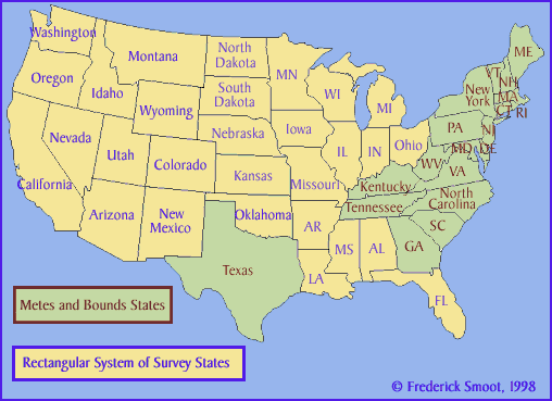
The Metes and Bounds system of Survey, as used in Tennessee and other
eastern states, Hawaii, and Texas, is an earlier system than the
Rectangular System of Surveys, (a.k.a. Public Land Survey System)
which is used in many
states. Simply put, the Metes and Bounds system of survey is an archaic survey
system were surveyed tracts are not linked to base line surveys, but rather to
neighboring tracts, roads, trees, rocks, meanders of waterways, etc.
But it was the best that could be had at the time it was used.
(The Metes and
Bounds States: Connecticut, Delaware, Georgia, Hawaii, Kentucky, Maine, Maryland,
Massachusetts, New Hampshire, New Jersey, New York, North Carolina,
Pennsylvania, Rhode Island, South Carolina, Tennessee, Texas, Vermont,
Virginia, and West Virginia.)
Metes and Bounds
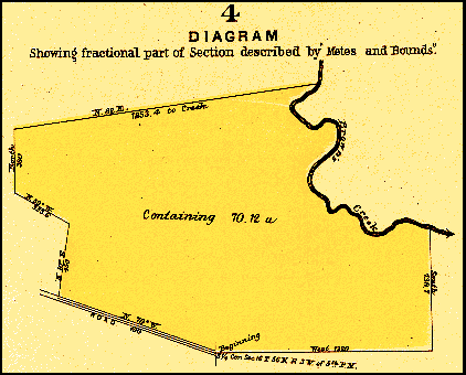 Copyright, J. R. Dunham, Surveyor and Dr’ft’sman,
Clinton Iowa, 1909
Copyright, J. R. Dunham, Surveyor and Dr’ft’sman,
Clinton Iowa, 1909
“In the Eastern and New England States the
system of surveying and describing lands by metes and bounds as followed
prior to the establishment of the rectangular system of surveys still
exists. The system at its best is imperfect and uncertain in its
working, having no known lines for base of surveys, and seldom any
official plats for references as to initial points. Diagram No. 4 shows
a tract of land described and platted by ‘metes and bounds,’
as the same would appear in deeds.”
Copyright secured by W. S. Brown, 1892

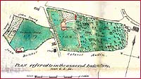
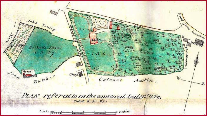
An 1826 English “Plan” in
the Metes and Bounds Style.
A Sample Metes and Bounds Survey
This survey below is from
Book 34, Plats & Surveys, page 31,
Tennessee’s 3rd
Surveyor’s District. The book can be found at the Tennessee State
Library and Archives, Nashville Tennessee,
but of course you would be shown a microfilm if
you wanted to see the survey: that is, microfilm Roll 35, Record Group
50 (RG 50).
The survey is an easy one to place. Because it is in “County of
Warren in the 34 Section of Said district”, and because it is on
the west bank of Hickory Creek, and because this survey came from a
“Plats & Surveys” book, we can pinpoint this tract exactly.
The “Plats & Surveys” book had a nicely drawn plat of the
tract. Incidentally, west of this tract is the town of Smartt,
Tennessee.
State of Tennessee Third District ~ Surveyed the
23rd day of January
1808 for William C. Smart assee. of William P. Anderson who is of John
Nelson his preference right of two hundred acres of land by virtue of
part of a Warrant No.1120 for five thousand acres leaving a balance of
said warrant yet to be Satisfied of 3657 acres located the
28th day of
August 1897 location No. 190 Situate in the County of Warren in the 34
Section of Said district beginning on a black oak on
the west bank of hickory creek of the barren fork of Collins river
thence north Seventy five degrees west one hundred & Sixty eight poles
with a conditional line between William Campbell & Said Smart to a
hickory then north ninety Seven poles to a
black oak near a Small branch a condition between
Samuel Priest & Said Smart thence with the condition north eighty
degrees east eighty eight poles then South eighty degrees east Sixty
poles then South Sixty degrees east fifty two poles then east forty two
poles to an elm on the west bank of hickory creek a
condition between William Priest & Said Smart thence with the condition
South twenty five degrees east twenty four poles then east twenty poles
then north Seventy degrees east Sixty poles then South eighty Six poles
then west one hundred __ forty ____ poles thence
South thirty three degrees west twenty eight poles to the beginning ~
James Priest &
Geo. R. Smart , Chrs.
/s/ Jno. A. Wilson D.S.
Sent to Registers Office 15th
Feby - 1809
Neither the black oaks, the hickory, or the elm would have helped us
locate this tract; the help came from other places. We know
McMinnville is in the 34th
section, therefore, we have narrowed the
area. However, any entry, survey, grant, or deed prior to 1806 will not
have the section mentioned. After that date, only small number of
surveys record the section.
All tracts have at least three corners (here a tract would be a triangle
in shape).
Where the survey line turned, you find a corner. The
“landmark” at the corner would be recorded. We could see a
corner description as simple as elm or as descriptive as the
dead tree where the boys once chased the rabbit.
We have two papers that might prove helpful. “Land
Terminology” is a glossary of old terms found in
land related documents. “Trees”
is a list of trees and other growing things that
also appear in old land related documents.
|
|


