This paper is copyrighted by Daniel Byron Dovenbarger, 1981, 1999. All reproduction rights are reserved. This paper is used here with his kind permission.
This online version was typed by Jo Roe Carpenter and coded in HTML by Fred Smoot.
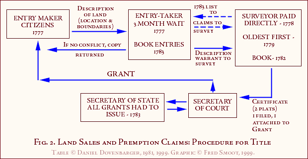
The first alteration of the North Carolina land policy in effect at the time of the Revolutionary War passed during the legislative session which began on November 15, 1777. That bill contained explicit instructions on the establishment of offices for taking entries and establishing titles to the unclaimed lands within the state. It explained how surveyors and entry-takers were to be selected. Each of these officers were required to take an oath of office binding him to perform his duties faithfully.(1) The settlers entering lands under this act had to be citizens of North Carolina. After locating the property he wished to claim, the entry-maker was required to submit a description of the location and boundaries to the entry-taker. There was then a period of three months in which any conflicting claims to the land were allowed to be registered with the entry-taker. Should no conflicting claims appear, the settler was given his copy of the land description, with another copy going to the surveyor as a warrant to survey the land. Following the return of this copy with a certificate by the surveyor to the secretary of the court, a grant for the land would be issued. The first bill called for all such warrants to be registered within the court during the next twelve months.(2)
Other portions of this same legislation defined the pay a surveyor was to receive for making a survey. For every survey of three hundred acres or less, the surveyor was to receive thirty shillings. For every one hundred acres above three hundred, he was to receive an additional three shillings. Also, the settler was to pay the secretary of the county court a sum of five shillings and the governor's secretary three shillings for the work involved in preparing a warrant. These fees were collected by the entry-taker, but were to be turned in to the state treasury twice a year, on October and April first. The entry-taker could deduct from the amount two percent as his salary.(3)
In order to insure the correct performance of these activities, the state required a bond of two thousand pounds to be entered for both of these officers. Additionally, the entry-takers had an eight-thousand-pound bond held by the governor as security for the public fees collected. Both of the officers cited could be fined for failure to do their duties. The surveyor and entry-taker were also subject to civil action for negligence.(4)
The fees collected in payment for land entries were established. Each settler was allowed to enter no more than 640 acres, where his claim bordered a vacant tract. If his plot fell between lines already surveyed, he could claim no more than one thousand acres. Additionally, each claimant was allowed one hundred acres for a wife and each child, at a price of two pounds and five shillings per one hundred acres. For any land over his quota, an entry-maker was required to pay five pounds per one hundred acres.(5) His acreage could be divided between one or more surveys within his quota.
When the surveyor had gone into the hills to survey what had been entered, he was to produce two plats of the land. Each must contain a scale, description, angles, distances, marks he had made, any water he had crossed, and, of course, the total number of acres. One of these plats was filed with the secretary of the local court; the other was annexed to the grant.
This legislative bill also provided that no survey was to be made without chain-carriers, who were to be paid by the settler. In order for the surveys to be orderly, this bill designated that all surveys proceed by natural lines (lines meeting at right angles). These were to run east and west, north and south. Such oblong or square plots were not to be over twice as long as wide. An exception to this was when the plot lay upon navigable water. In such cases, the breadth was not to be more than one-fourth the length.(6) This restriction prevented any one landowner from monopolizing the waterfront and its concomitant benefits.
The other land bill affecting Middle Tennessee passed during this session created Washington County, which contained all the present lands of Tennessee.(7) This bill had been submitted by John Sevier on December 18, 1777. John Carter was named the entry-taker for the new county, while James Stuart was to act as county surveyor.(8)
When the legislature of North Carolina next met on April 14, 1778, one of its tasks was to decide on measures to further explain and regulate land dealings, as unforeseen problems had arisen. The new act stipulated that where a survey revealed that the tract contained less land than the amount originally named, the settler was to receive a refund of the amount paid in excess of land actually obtained. Another provision required that all money paid to the surveyor go directly to him; the entry-taker was not to accept such funds.(9) Men who were to get lands as reward for their services in the Revolutionary War under North Carolina, a total of 2,648, had the time limit for acquisition of such lands suspended. Also, the settlers moving into the western area were forbidden to claim lands not ceded to North Carolina by Indian treaties. Where such claims had occurred, they were declared void, with refunds to be given. The law clarified which lands were considered to be within Indian territory. Another problem was resolved by providing that all churches were to be exempted, along with up to two surrounding acres, from being included in any claims. The funds the entry-taker did receive were made not payable until three months after they had been collected, in order to establish fairness for those filing close to either April or October first.(10)
By 1779 another problem had developed requiring immediate attention. The settlers moving westward and settling in the river valleys were uncertain whether to pay taxes to North Carolina or Virginia. Naturally, whenever an unwanted official of one state tried to assert his authority, it was in the interest of these settlers to feign certainty that they were within the jurisdiction of the other. Accordingly, commissioners were appointed to meet with similarly appointed men from Virginia to settle the boundary lines. This commission was to begin a process that was to last another one hundred and thirty years. Oroondates Davis, John Williams, Caswell James Kerr, William Bailey Smith, and Richard Henderson were named to complete the negotiations with Virginia's representatives. They were to start at the western end of a line, calculated to lie along 36 degrees 30 minutes of latitude, established by the team of Jefferson-Fry earlier in the century. From there they were to run a line due west. For their efforts, the commissioners were to be paid ten dollars per day. These commissioners nominated the surveyors who would actually be doing the surveying work. These surveyors would be paid, along with any attendants, upon receipt of a report filed with the General Assembly.
Another bill of interest to the developing pattern of land disposal was one relating to the occupants of the so-called Granville lands. This law established a pattern followed later in Tennessee. In cases where a person had settled upon a former entry and had lived seven years peaceably in possession of the land without any legal action taken by an earlier entry-maker, the actual occupant was to receive preference to the { p 19 } land in any jury trial arising from a dispute over the land. Also, any improvements made upon the land gave the party who made them preference in filing for the land. Such improvements included houses, clearings, enclosed acreage, or cultivated fields. Also affirmed was the right of appeal from decisions of the local courts involving land disputes.
The order of conducting surveys was also specified. The oldest warrants by order of entry were to be surveyed first. This regulation was an attempt to stop surveyors from abusing their position by favoring the entries of their friends. All surveys warranted to the surveyor were to be returned within twelve months. A sum of one hundred pounds was forfeited from the surveyor's bond for each failure to return warrants within the allotted time.(12)
Late in October of 1779, the General Assembly met again at Halifax, North Carolina. There, some vital changes were made in the system established the previous spring. The county courts were given full power to determine whether new trials were needed in questions concerning land. Appeals were canceled; those already begun were to be completed, however. Rights to lands claimed by an entry-maker who died were secured in his legal heirs in fee simple. Boundary disputes settled out of court after being brought for action were to be handled as if the settlement had been decided by a jury. If dissatisfaction continued over the settlement, the matter could go to an actual trial. Such jury trials were held upon the site of the land question. Failure of a juror to appear at the hearings without just cause could subject him to a fine not to exceed 250 pounds.
Other actions of the Assembly directed surveyors. Surveyors running lines on lands bordering bodies of water could disregard previous claim lines and continue the survey as in other claims. This instruction blocked the old problem of men claiming waterfront lands to the exclusion of others. Finally, evidence is given for the first time that speculator's actions were being watched. To avoid "artful and designing men" acquiring too much land, a procedure was established in which citizens under oath could file a complaint of fraudulent land practices. The Governor would then suspend action on the named grants. The county court would order a jury impaneled to hear the complaint, and action sustaining the complaint voided the land claims in question.(13)
The one bill changing land policy passed during the April session in 1780 was minor. It took notice of the fact that the twelve months granted to complete the warranted surveys was too short. An extension was therefore granted, but all other rules remained the same. Two years were given for all people to register their claims.(14)
Later in the same year, the General Assembly at Hillsboro continued the action involving the survey of the boundary with Virginia by noticing that lands thought to have been in Virginia were now being entered and claimed. For justice to those who already were residing on such lands, the General Assembly suspended until the following Assembly all such entries. The same act required the entry-takers of Washington and Sullivan counties to stop accepting claims on all the lands in question.(15)
Virginia, in 1780, declared void the claims that Richard Henderson had tried to establish on western lands through the Transylvania Company. These claims included part of Middle Tennessee but never really affected land sales in the area.(16) At least after Virginia's action there was no doubt that the state of North Carolina was the only legitimate authority for disposing of the lands in the Cumberland region.
The year 1781 witnessed the passing of new laws affecting the surveying and entering of lands. The first of these extended the time allowed to surveyors for finishing the warranted surveys. The Assembly granted another twelve months. Also, the Assembly continued the suspension of entry-taking for the lands that had been newly determined to be in North Carolina so that adequate time could be allowed to hear the claims of settlers in the area.(17) The other action of the Assembly abruptly and completely closed the entry of any land claims. The Assembly forbade entry-takers from accepting any descriptions of lands; any that were accepted were declared null and void. This act repealed the earlier actions of the past several years.(18) Land troubles and the conclusion of the Revolutionary War brought this about. North Carolina wanted to secure lands for its soldiers before any more land was entered.
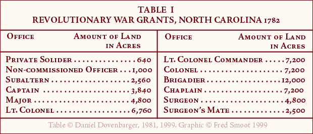
The acts of the April session of the General Assembly of 1782 came as relief measures to the officers and soldiers of the Continental Line. The first of these acts provided designated amounts of land for each of the various officers. The Assembly dispensed land in the amounts shown in Table 1.
In some cases, land set aside for the military claims had been settled. The Assembly granted preference to the families already living on the land. No grants were to include salt licks or springs, or the surrounding 640 acres, now declared to be public land. Measures of this act named Absalom Tatom, Isaac Shelby, and Anthony Bledsoe as commissioners to superintend the laying off of land for soldiers. Any vacancy in the office of commissioners was to be filled by appointment of the Governor. This act explicitly stated that the Governor was, when ready and able, to appoint no more than one hundred guards with officers for protection of the commissioners in the wilderness. Each commissioner received a certificate for nine thousand acres, with the stipulation that this tract be in a single grant. Commissioners could appoint three surveyors, the necessary chain-carriers, markers, and hunters. Each surveyor would get 2,500 acres, while other assistants received warrants for 640 acres. Guards on this expedition received certificates for 320 acres.(19)
Other important legislation affecting Middle Tennessee was also passed during the same session. One bill provided a grant of two hundred thousand acres to Richard Henderson in compensation for the cancellation of his claims under the Transylvania Company.(20) Also, the same bill { Page 23 }
{ Page 24 } which listed the amounts of land for each military rank provided a single grant of twenty-five thousand acres to Nathaniel Greene for his services as general.(21) More important was the confirmation of land patents which were held on land discovered to be in North Carolina. This ended the suspension begun two sessions previously. The settlers in the region were allowed now to complete the process which would grant them title. Some of these lands had been occupied a long time. One grant to John Buchanan of 1,250 acres reached back to 1753.(22) The rights guaranteed to the occupants were also extended to any purchaser of the lands named in the act.
Also, more carefully explained was the process for claiming land in that region. The local magistrates were to warrant a sheriff to call a jury in order to determine who should be put in possession of land in question. This act was not to be a bar to any further suits arising from dissatisfied land owners, nor was it to take effect until the first of December, 1782.(23) Other duties of the surveyor were established. A book was to be kept listing the names of men with pre-emption claims, and what was granted them. It was to be returned to the General Assembly for examination. A map was also to be constructed diagramming the country explored and the tracts surveyed.(24) Another bill passed in 1782 by the General Assembly authorized an extension of two years for the period in which land entries could be filed. This recognized the insufficiency of the time allotted previously. Efforts to establish a valid claim to land where one of the needed witnesses had left the county could be aided by securing a writ of dedimus from the county or state in which the witness was now located.(25)
The biggest change in 1783 was a bill passed April 14, creating Davidson County, which at the time comprised all of present-day Middle Tennessee.(26) The organization of Davidson County allowed the creation of new offices and officials. On January 6, 1784, Samuel Barton became the new entry-taker, and Daniel Smith was elected surveyor.(27) A list of the officials in this county indicates that many men held both important county positions and leadership positions in the militia. Anthony and Isaac Bledsoe, Samuel Barton, Daniel Smith, George Winchester, and David Shelby all served, at times, in two or more positions.(28)
Land laws in 1783 represented a return to earlier freedoms. In the most important bill to "renew credit and redeem specie," land offices were re-organized and re-opened. Since the new county organization, this was the first opening of a land office in what was to become Middle Tennessee.(29) Also, by this time, the outlines of the military reservation had been laid out and warrants for eight million acres authorized.(30)
Parts of the act passed this session sought to protect Indian rights. Entries made upon Indian lands were void; a fifty pound penalty could be levied for anyone attempting to claim Indian land. The act established a penalty of one hundred pounds for attempts to purchase Indian lands from the various tribes. A lesser fee of fifty pounds was created for those caught grazing animals, hunting, or foraging on Indian lands.
Other restrictions appeared. No claims over five thousand acres were allowable, and each claimant had to be a North Carolina citizen. Ten pounds per one hundred acres had to be paid in specie or equivalent value when making the entry. After the claimant had made a description of the lands he was entering, he paid the entry-taker, who endorsed the paper. The entry-taker listed the name of the claimant, and the number of acres claimed with the date this was transacted, and entered this into a book kept by order of the General Assembly. As before, if no one else tried to enter upon the same lands within three months, the entry-taker would deliver to the claimant party a copy of the entry with its listed number and a warrant to the surveyor to complete a survey of the land. If another claimant for the same property appeared within the three months, his number and entry were recorded opposite the claim made previously. The whole matter would then be transmitted to the court for settlement of the better claim. A restriction in this law on land entry was that no one could make a claim upon the lands in the military district (or on the island in the Holston River, which had been reserved as a treaty ground for meetings with Indians).(31) These regulations permitted, once again in 1783, settlers to begin the process to secure titles to the western lands.
The first military land office opened for the western lands opened in Hillsboro, North Carolina, on October 20, 1783. The man designated to locate and survey entries was William Tyrrell Lewis.(32) The entry-taker was John Armstrong. Evidence in letters from that period reveals how eager land speculators were for this land office to open. Material touching on this subject will be examined in detail in the second portion of this study. Now it may merely be noted that in a letter from William Blount, a member of the General Assembly, to John Donelson on May 17, 1783, Blount explained that the land office bill had passed, but expressed his deep disappointment that the office would not open until October. A market for land was opening up.
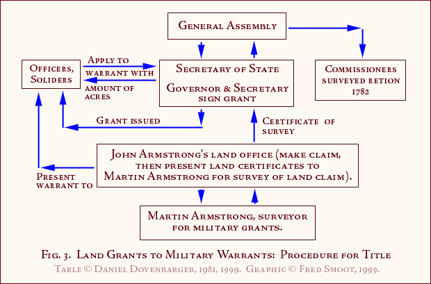
Other land legislation continued to be produced. Chapter three of the legislative acts passed during the first session of 1783 in Hillsboro was an act regulating the disposal of military grant lands. Officers and soldiers were to apply to the Secretary of State for a warrant of survey. This warrant would list the quantity of land granted. Next, to acquire the land, the soldier presented the warrant to Colonel Martin Armstrong. Martin Armstrong had become the surveyor for military grants. As surveyor, Martin or a deputy would execute and return to the Secretary's office a certificate of survey to match the warrants. Martin Armstrong { Page 28 }
{ Page 29 }
{ Page 30 } was to do this in the same time allotted to other surveys. Likewise, he was to be rewarded with the same fees and assistants. Where there was contention over the same piece of ground, the surveyor would determine the outcome by casting lots. No warrants were issued before October 1, 1783, and three years were granted to complete the military land grants. Once completed without legal objection, the military claims were valid against all later claims. The act demanded that the grants be signed by the governor and his secretary of state, and recorded in that office.
The boundaries of the military lands were established. The line ran from the intersection of the Cumberland River with the Virginia line straight south fifty-five miles. From there the line ran due west to the Tennessee River, down that river to its second (most westerly) intersection with the Virginia line (later the Kentucky border). From there the line ran east to its origin on the Cumberland River.
No person, except soldiers or holders of military land warrants, could enter lands in this region by law. Exceptions were granted to those who had been in the area for three years, and those living in the Cumberland River settlements. Personal exemptions gave Anthony Bledsoe, Absalom Tatom, and Isaac Shelby permission to get title to their claimed lands by entering them with the entry-taker of Davidson County. The surveyor for these private claims was to get the same amount of pay as public surveyors, and the fee for the lands was established at ten pounds for every one hundred acres.
Men who had served in North Carolina Revolutionary forces, but not long enough to be considered rendering full service, were allowed to claim some of the military land also. They had to have served at least two years. The warrants they received were proportionate to the office they held and the length of their service. Their service would be compared with a full service time of seven years. By the last provision of this act, Alexander Martin and David Wilson were both granted two thousand acres for their services.(33)
Other acts passed during the same session regulated either the officials handling the entry of lands or the exact mechanics of that process. Under the first category fell a bill requiring the entry-taker to deposit a sum of ten thousand pounds with the governor as a bond for the performance of his duties. A larger bond was required of him as security for his handling of the public funds. Both these sums were merely an increase in what was already required.
Additional regulations required the secretary of state to issue grants for all valid surveys returned. This law caused speculation that the secretary of state had been selective in the issuing of grants. All grants were made deliverable on April or October first of subsequent years. Following the delivery of the grants, the claims were to be perfected within twelve months. All claims were to be registered in the local counties where the land was located. This act also stipulated the fees to be paid by claimants. Entry-takers now received four shillings for all services, while the surveyor would get sixteen shillings for every survey of three hundred acres or less, with an additional four shillings for each one hundred acres above three hundred. Entry-takers could accept fees for the secretary and keep them until the other funds he collected were turned over. Five percent was deductible as salary for the entry-taker.
An additional act required surveyors to return two lists. These contained the name, number of acres, and date. Both copies were signed by the surveyor and the secretary of the court. One remained with the surveyor, while the other copy was filed with the secretary. Twice a year the secretary would deliver to the surveyor warrants to survey the filed claims. The Assembly ordered the surveyor to proceed in his survey by the chronological date and number of the warrants. Within twelve months the surveyor had to lay off and plat, with the number and date of the warrant, a description of the land, giving number of acres included and any other pertinent information. This plat certificate had to be returned to the secretary within eighteen months. Every default could result in a fine of fifty pounds. The law forbade the surveyor to proceed to survey any lands that were under caveat of the court, since disputes had to be settled before surveys could continue. When local courts informed the governor that an oath of fraud had been sworn, the governor could suspend any grant involved.(34)
The General Assembly also responded to the slowness of the past process of registering lands by allowing all grants to be valid even if not registered within the time limits stipulated by earlier law. This continuation acknowledged the failure of the old plans. In legislation affecting Davidson County, the General Assembly permitted eighteen months for claimants to pay the entry-taker the required fee for their lands, because money was so difficult to obtain in the western lands. No grants were to be issued, however, until that money had been collected.(35)
The year 1783 brought amazing changes to the land sales of North Carolina. The contents of one bill ceded the western lands to the United States Congress under the Articles of Confederation. Sovereignty was kept over the lands until the United States Congress should accept such a cession, but no further entries were to be made in the region. After May 25, 1784, John Armstrong's office was closed, and he was exempted from legal action taken against him for refusing to accept entries. Any claims he accepted would be void. Exceptions to this provision were numerous. Commissioners, their agents, surveyors, guards, hunters, chain-carriers, and markers used in surveying military lands could continue to make entries for their land.(36) By this time Armstrong's office had already accepted entries for nearly four million acres.(37)
Controversies stemming from John Armstrong's land office affected the legislation passed in 1784. The surveyor of Greene County (created from Washington County in 1783)(38) was authorized to survey all lands granted under the Armstrong land office. Concern surrounding John Armstrong's action as entry-taker stemmed from his connections with John Gray Blount. Jurors in Orange County, North Carolina, on April 14, 1784 swore a charge of fraudulent land claims. Specifically, Armstrong, as entry-taker, was accused of issuing fraudulent and unlawful warrants for John Gray Blount and Thomas Blount. Implicated too was William Polk. Apparently there was an attempt by this group to get title to more land than originally claimed in the grants.(39) Therefore, the Assembly ordered another surveyor to re-examine the lands Armstrong had warranted. There was raised the question whether a surveyor could include in his report a false amount of land in a particular survey. By allowing "padded" surveys. Armstrong could have issued more land than was granted to the Blounts. This will be discussed more thoroughly later.
The Assembly once again extended by twelve months the time limit for pre-empting settlers to get cash to pay for their land. A re-affirmation of the General Assembly's previous orders stipulated that all surveys had to be square or oblong. In cases where the surveyor discovered that the lands he was surveying already were granted he could go ahead and survey an equal portion of ground in unclaimed lands in order to complete the warrant.(40)
New instructions regulating the surveyor's paperwork came into being that year. His books now had to have the name, number of the location, number of the warrant, quantity of acres, when it was located, where it was located, a description of the plot, and other information identifying the land. The land office was to be in Nashville, and entries made elsewhere were void. All grants warranted to be surveyed were to be completed in one tract with reference to the four cardinal points, making each tract square or oblong. Exceptions to the square tract rule existed; where three cardinal points were used, the fourth line or corner could be a river, creek, or mountain, regardless of its orientation. A new requirement stated that no grants less than one thousand acres could extend across a river.(41) Again, this was to keep to a minimum the practice of one or a few men grabbing up both banks of a river to the exclusion of the interior owners. This would be characteristic of speculators.
In an effort to bring relief for mistakes in entry-making, another law took effect. Mistaken entries were valid but were to be re-surveyed, or the surveyor who had originally surveyed the land could re-submit a copy of his plat. The mistakes this law addressed consisted of settlers entering their lands in the wrong county office by not knowing in which county their property really belonged. This law was directed to two North Carolina counties but is interesting for the light it sheds upon the mistakes that could be made and the response made to such mistakes.(42) The Assembly guaranteed the validity of such mistaken grants but wanted them filed in the correct county.
Isaac Shelby, Anthony Bledsoe, and Absalom Tatom again served as surveyors under a 1784 law. The allotted twenty-five thousand acres to Nathaniel Greene were declared his in fee simple. The trio mentioned above located the lands for Nathaniel Greene and established the bounds. This land was located along the Duck River. Other claims located within the boundaries of this tract were declared void.(43)
Chapter twenty of the laws of the General Assembly, passed the same session, repealed the exemption of Hoston Island from entry-making. Conditions in the disposal of land necessitated some additional legislation. All the unregistered grants in the land office were granted an additional two years for registry. Other forms of proof of ownership were also granted two years for registry. The law empowered county courts to accept writs of dedimus authenticated from other courts in or out of state as proof of ownership.(44)
Late in October of 1784 another problem in the disposal of land was dealt with in legislation passed by the General Assembly. The act sought to prevent the issuing of grants when such grants had been paid with counterfeit certificates. The new law compelled the entry-taker to turn over to the secretary of state any counterfeit certificates with all relevant information about the origin of the certificates. The entry-taker accepted such information from the claimant under an oath of truth. The secretary of state would stop such grants until true certificates for the correct amount had been paid. Since the entry-taker would be short in his accounts for the amount of certificates he had turned over to the secretary, the secretary issued a certificate of amount which would be included in the public accounts when the land fees became due. Surveyors in the western areas had had trouble collecting the money due them, so the secretary was authorized to stop grants until the surveyor had been paid. The last provision of this act opened up all unclaimed land within the state for military claims, if the land set aside in the military reserves was insufficient.(45)
Actions in 1785 reversed decisions made a year earlier. The United States Congress had not responded to North Carolina's cession of her western lands. In the meantime, an election had changed the composition of the General Assembly of North Carolina. The new legislature promptly repealed the act of cession. The controversy surrounding this first act of cession shows the nature of politics and land in North Carolina. A careful examination of this topic by Mariella Waite has revealed the strongly geographical divisions within North Carolina on the question of cession. The western counties tended to be strongly opposed to the cession. Citizens there needed cheap land and protection from the Indians, while eastern seaboard interests urged cession.(46)
Once the repeal had been completed, the General Assembly's actions continued slight alterations of the established land system. Surveyors were now given eighteen months in which to complete their surveys under warrant. Successors to entry-takers must complete warrants unfinished by the previous official, but would not be held liable for funds collected before their assumption of office.(47) Other changes had to wait nearly a year for remedial legislation.
Another flurry of legislation affecting land emerged from the General Assembly which met in November, 1786, in Fayetteville. Chapter twenty of the laws passed in this session sought to protect pre-emption rights. The first entry-maker could take up to two years to obtain a survey of his claim. Any claims on his land during this period were void. Therefore, surveyors were logically given two years in which to complete the surveys warranted to them. Lands west of the Cumberland mountains could not be granted until the end of the following session. Exceptions existed for military, pre-emption, and guard-right warrants. Additionally, another twelve months was granted in which soldiers could locate their lands. The following two years were also allowed for soldiers to complete the registry of their lands. A similar time limit was created for deeds and other forms of proof.(48)
The same year witnessed the creation of Sumner County by dividing Davidson County. A third Middle Tennessee county came into existence two years later in November, 1788 by another split from Davidson County. The Assembly named the new county Tennessee.(49)
Abuses in the land system continued because the Assembly instructed the surveyors to do their work according to priority, based upon date of entry and number of warrant.(50) A now-familiar act in 1788 extended the time for registration another two years. The repeated extension of time for registration indicates the slowness with which the acquisition of land titles was progressing and the extent to which speculators raced ahead of the actual settlement of land. Speculators had to wait several years for their lands to become marketable. In the meantime, there was little cause to spend money surveying and registering lands held. These periodic extensions of time for registration permitted a substantial landholder to maintain possession while waiting for land prices to climb.
Another provision of this law allowed all entries made west of the mountains to occur in the county in which the entry-maker was a resident. If he were not a resident, he was required to file his lands with the register of Hawkins County.(51) The area known now as Middle Tennessee got its first long-term designation by the Assembly in 1788 also. The labeled it the Mero District. Mero was the Spanish governor of New Orleans at the time.(52)
Land laws continued to pour forth from the General Assembly relating to the western territory. An early act in the November session of 1789 again ceded the territory to the United States. The boundaries of the ceded land were established and a list of restrictions presented. The primary qualification was that soldiers promised lands by North Carolina would be allowed to perfect their titles to that land or establish titles if that process had not begun. Other restrictions were that the population was not to be counted toward North Carolina's representation, the land was to become national public property for the future creation of additional states, debts contracted under the laws of North Carolina were still binding, and citizens in the region were liable for taxes passed by the United States Congress. Also, North Carolina's laws were enforceable until the cession was accepted, non-residential property holders in the territory could not be taxed differently from residents, and no bars were to be created to prevent the people south of the French Broad and Holston Rivers from filing pre-emption rights. The United States Congress had eighteen months in which to accept this act of cession. In the meantime, full sovereignty over the region was maintained by North Carolina.(53)
The United States Congress accepted the cession with its limitations. North Carolina had issued some 8,118,601.5 acres worth of land certificates. Originally, North Carolina had agreed to limit the continued action on such warrants to 1792. Later, in several acts of dubious legality, North Carolina tried to extend the period to 1800.(54) Once the cession was accepted by Congress, however, real jurisdiction over the territory resided in Congress through the action of the territorial government then created, until such time as a state was formed from the territory.
While waiting for the United States Congress to act, North Carolina continued to alter laws affecting Middle Tennessee lands. The General Assembly in 1789 required that the salt licks earlier reserved for the public be released. Commissioners were established to complete the task. A complete list of salt springs and licks in Davidson, Sumner, and Tennessee counties was required. Those licks declared worthy or suitable for salt production would be retained; those not so productive would be declared vacant and sold with the surrounding 640 acres. The sale of these licks was to be preceded by three months of advertisements at the local court houses. Proceeds of two of the sales were to go to the Davidson Academy, while the rest was placed at the disposal of the state for improvements in the Mero District. One requirement was that the new owners would not enclose the lands to exclude livestock. The salt springs most productive were not sold, but leased in return for an annual yield of salt.(55)
In other action, the Assembly again granted three additional years for the surveying of lands that had been entered. This included land entered in John Armstrong's office as military warrants and pre-emption claims.(56) The year 1789 had hardly passed, however, when monumental changes began, most of which had been triggered by North Carolina's cession of her western lands.
The Cession Act of 1789 had succeeded where the previous one failed. Congress accepted the deed for the territory and the Cession Act on February 25, 1790.(57) Henceforth, the area which was to become Tennessee was under new jurisdiction. Although North Carolina would occasionally attempt to control and regulate the disposal of lands in the now-ceded territory, there was little the old state could do. Her legislative acts were now subject to the acts of Congress and subsequently to those of a new state. At the time, little could be known about how the new authorities might alter the already established system of land surveying and registration. However, in a time when, as Waite suggest, "land policies seem to have been guided more by the speculators, who were to be found in any county and with any political affiliation, than any other group," it was most likely little would be done to rock the established boat.(58) The examination of land law and newly passed provisions, and the disposal of the Cumberland territory, will continue when we turn to view the actions of the government in the Territory South of the River Ohio created by Congress on May 2, 1790.(59)
Prior to releasing its western lands, the legislature of North Carolina had completed an awesome task. The framework of laws just examined provided for the measuring and granting of an immense tract of wilderness. An analysis of those laws indicates trends which depict the quality of land survey business during the period. As the laws were passed, evidence arose that some were not being observed. The nature of the bills and their language reveals unethical or unlawful practices that the legislature sought to correct. Relatively simple at first, the system established for obtaining a grant grew increasingly complicated as the legislature of North Carolina attempted to prevent sharp practices Remedial legislature is everywhere evident in the land laws.
An example of this remedial nature of the bills is the bill preventing entry-takers from collecting the surveyors' fees. This provision suggests the entry-takers were pocketing the funds themselves. Also, it has already been shown that the irregular tracts of land seen in Tennessee did not comply with the law demanding square or rectangular parcels. Yet, this law was enacted twice. The surveyors themselves were increasingly burdened with more detailed paperwork. This work involved retaining copies and volumes for legislative inspection as well as making maps of tracts they had located. Some laws targeted favoritism by requiring a strict handling of the warrants and grants by chronological number and demanding the secretary of state grant all valid claims. Also, the legislature continually extended the time allowed for the registration of claims, survey of warrants, and registry of grants. Whether this was because of pure slowness in measuring the lands is unknown. It also favored speculators' interests. Repeatedly, laws passed designed to prevent a claimant from monopolizing land along waterways. Furthermore, an elaborate system was devised to allow private citizens to swear out complaints of fraud against other claimants. Other illegal practices are indicated by specific laws passed to protect Indian lands and limiting the total amount of land a party could claim to five thousand acres. Finally, the obviously illegal practice of using counterfeit certificates was recognized as a major problem by a law specifically written to modify the land office system to deal with claims paid with such certificates.
All of these legal features indicate to some extent the legislative reaction to evils as those evils became recognized. The simple system devised in 1777 grew increasingly complex in an attempt to counterbalance the sharp practices of speculators and surveyors. Practices that may have been only unethical in 1777 gradually became illegal. Other acts in the land business were always illegal but became specifically addressed by legislative enactments. The theme that constantly runs through the bills of that period is that the legislature was trying to catch up to the practices of the men involved with surveying. However indicative the nature of the bills must be, it is necessary to complete an examination of the acts and the nature of the territorial government before we can turn to examine what evidence there is of the actual extent of illegality and speculation under North Carolina's land law.
Endnotes, Chapter II
(1) Edward Scott, ed., Laws of the State of Tennessee including those of North Carolina Now in Force in this State from the Year 1715 to the Year 1820, Inclusive, 2 vols. (Knoxville: Heiskell & Brown, 1821), 1:159 et seq.
(2) Ibid.
(3) Ibid., 1:163.
(4) Ibid., 1:164.
(5) Ibid., 1:160.
(6) Ibid., 1:162.
(7) Ibid., 1:122.
(8) James H. Pauly, "Early North Carolina Migrations into the Tennessee Country: 1768-1782" (M.A. Thesis, Middle Tennessee State University, 1969), p. 109.
(9) Scott, 1:224-26.
(10) Ibid.
(11) Ibid., 1:235-36; Summers, pp. 697-700.
(12) Scott, 1:230 seq.
(13) Ibid., 1:238-40.
(14) Ibid., 1:250.
(15) Ibid., 1:252.
(16) Edward Albright, Early History of Middle Tennessee (Nashville: Branden, 1909), p. 41.
(17) Scott, 1:253.
(18) Ibid., 1:255.
(19) Albert V. Goodpasture, "Education and the Public Lands in Tennessee," American Historical Magazine 6 (1901): 212; Mariella D. Waite, "The North Carolina Cession of 1784" (M.A. Thesis, University of Florida, 1965), p. 30; Scott, 1:258-60; Harriette Louisa Simpson Arnow, Seedtime on the Cumberland (New York: Macmillan Publishing Company, 1960), p. 31.
(20) Waite, p. 31.
(21) Scott, 1:258-59.
(22) Ibid., 1:265.
(23) Ibid.
(24)Ibid., 1:260.
(25) Ibid.
(26) Albright, p. 111.
(27) Ibid., p. 112; John Carr, Early Time in Middle Tennessee (Nashville: C. Stevenson and F. A. Owen, 1857), p. 28.
(28) Carr, pp. 28-38.
(29) Maude Alexander, "Public Lands of Tennessee" (M.A. Thesis, George Peabody College, 1927), p. 22.
(30) Ibid., p. 23.
(31) Scott, 1:267.
(32) Samuel Cole Williams, Beginnings of West Tennessee (Johnson City: Watauga Press, 1930), p. 42; Alice Barnwell Keith and William H. Masterson, eds., The John Gray Blount Papers, 3 vols. (Durham: Christian Printing Company, 1959), 1:57.
(33) Scott, 1:267.
(34) Ibid., 1:270.
(35) Ibid., 1:281-83.
(36) Ibid., 1:284-85; Waite, pp. 40-41.
(37) In August of this year, settlers in the western lands of North Carolina organized the state of Franklin. It was not recognized by the United States Congress. Unfortunately, after its dissolution in 1789, most of the records relating to the government of Franklin were lost. It would be interesting to know what type of land laws had been devised by the western leaders. One authority believes, however, that Franklin largely adopted the land laws of North Carolina as they existed. Goodpasture, p. 214; Thomas P. Abernethy, From Frontier to Plantation in Tennessee (Chapel Hill: North Carolina Press,1932, pp. 79-89.
(38) Scott, 1:282.
(39) Keith, 1:57.
(40) Scott, 1:286.
(41) Ibid., 1:287-89.
(42) Ibid., 1:288.
(43) Ibid., 1:289-90.
(44) Ibid., 1:291-92.
(45) Ibid., 1:304-5.
(46) Waite, pp. 74-82.
(47) Scott, 1:336.
(48) Ibid., 1:375-76.
(49) Ibid., 1:377, 401.
(50) Ibid., 1:393-94.
(51) Ibid., 1:400-401.
(52) Helen Bullard Krechniak, Cumberland County's First 100 Years (Crossville, Tennessee: Crossville Century Commission, 1956), P. 8.
(53) Scott, 1:405.
(54) Sarah V. Williams, "History of the Tennessee Public School Lands" (M.A. Thesis, Vanderbilt University, 1944), p. 4.
(55) Scott, 1:412.
(56) Ibid., 1:421.
(57) Ibid., 1:436-38.
(58) Waite, p. 32.
(59) Keith, 1:39-40.
This paper is copyrighted by Daniel Byron Dovenbarger, 1981, 1999. All reproduction rights are reserved. This paper is used here with his kind permission.
This online version was typed by Jo Roe Carpenter and coded in HTML by Fred Smoot.