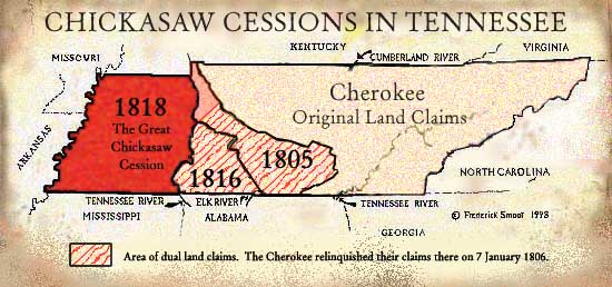
The Treaty of Hopewell (10 January 1786) between the United States government and the Chickasaw Nation first established the bounds of the Chickasaw Nation. Between 1805 and 1818, three major treaties contained Chickasaw cessions. The 1805 and 1816 Cession limited Chickasaw claims, and the 1818 Cession extinguished major Chickasaw claims in Tennessee.
Treaty of Hopewell
28 November 1785 (9)
Cherokee Boundaries
The boundary allotted to the Cherokees for their hunting grounds . . . shall be the following, viz: Beginning at the mouth of the Duck River, on the Tennessee River: thence running north-east to the ridge dividing the waters running into the Cumberland from those running into the Tennessee; thence eastwardly along the said ridge to a north east line to be run, which shall strike the river Cumberland forty miles above Nashville; thence along the said line to the river; thence up the said river to the ford where the Kentucky road crosses the river; thence to Campbell's line, near Cumberland Gap; thence to the mouth of Claud's Creek, on Holston; thence to the Chimney-top Mountain; thence to Camp Creek near the mouth of Big Limestone, on Nolichucky; thence a southward course six miles to a mountain; thence south to the North Carolina line; thence to the south Carolina Indian boundary, and along the same south-west over the top of the Oconee Mountain till it shall strike Tugalo River; thence a direct line to the top of Currahee mountain; thence to the head of the south fork of Oconee river.This boundary description runs from west to east. The Blount's Treaty, of 2 July 1791, has similar bounds but runs east to west. Here we see a small modification of the line in Middle Tennessee.
Treaty of Hopewell
10 January 1786 (10)
Chickasaw Boundaries
The boundary of lands hereby allotted to the Chickasaw nation to live and hunt on . . . viz. Beginning on the ridge that divides the waters running into the Cumberland, from those running into the Tennessee, at a point in a line to be run north-east, which shall strike the Tennessee at the mouth of Duck river; thence running westerly along said ridge, till it shall strike the Ohio; thence down the southern banks thereof to the Mississippi; thence down the same, to the Choctaw line or the Natchez district; thence along the said line, or the line of the district eastward as far as the Chickasaws claimed, and livid and hunted on, the twenty-ninth of November, one thousand seven hundred and eighty-two. Thence the said boundary, eastwardly shall be the lands allotted to the Choctaws and Cherokees to live and hunt on, and the lands at present in the possession of the Creeks; saving and reserving for the establishment of a trading post . . . at the lower port of the Muscle shoals . . . to be used and under the government of the United States of America.In the Treaties of Hopewell 1785, and 1786, above, there was no definitive boundary between the Chickasaw and the Cherokee Nations.
Chickasaw Cession
23 July 1805 (11)
the Chickasaw Nation of Indians . . . cede to the United States . . . the tract of country . . . beginning on the left bank of Ohio, at the point where the present Indian boundary adjoins the same, thence down the left bank of Ohio to the Tennessee River, thence up the main channel of the Tennessee River to the mouth of the Duck River; thence up the left bank of Duck River to the Columbian Highway or road leading from Nashville to Natchez; thence along the said road to the ridge dividing the waters running into the Duck River from those running into the Buffaloe River; thence eastwardly along said ridge to the great ridge dividing the waters running into the Tennessee River from those running into the Buffaloe River near the main source of Buffaloe River; thence in a direct line to the great Tennessee River near the Chickasaw Old Fields or eastern point of the Chickasaw claim on that river; thence northwardly to the great ridge dividing the waters running into the Tennessee from those running into Cumberland River, so as to include all the waters of the Elk River; thence along the top of the said great ridge to the place of the beginning . . .This cession does not mention the headwaters of the Duck River. Either this is an omission on the part of the treaty makers, or, possibly, the Chickasaw did not have claims to the eastern headwaters of the Duck.
Dearborn's Treaty
7 January 1806 (12)
Certain Cherokee Claims Relinquished
...the Cherokee Nation of Indians . . . relinquish all right, title, interest, or claim . . . to all that tract of country which lies to the northward of the river Tennessee, and westward of a line to be run from the upper part of the Chickasaw Old Fields, at the upper point of an island called Chickasaw Island, on said river, to the most easterly head of the waters of that branch of said Tennessee River called Duck River...Note that there is no western boundary to this Cherokee Cession and the waters of the Elk River are omitted.
Two small areas along the north side of the Tennessee River, in present day Alabama, were reserved by the Cherokee Indians.
...the United States . . . will use its influence . . . to prevail on the Chickasaw Nation of Indians, to agree to the following boundary between that nation and the Cherokees to the southward of the Tennessee River, . . . the United States do not engage to have the aforesaid boundary line established, but only to endeavor to prevail on the Chickasaw Nation to consent to such a boundary line . . . It is further agreed on the part of the United States that the claims which the Chickasaws may have to the two tracts . . . on the north side of the Tennessee River shall be settled by the United States . . .
Elucidation of a Convention
with the Cherokee Nation
11 September 1807 (13)Here, the bounds agreed upon by Dearborn's Treaty were restated.
...the tract of country between the Tennessee River and the Tennessee Ridge [so called] which tract of country had . . . been claimed by the Cherokees and the Chickasaws; the eastern boundary whereof is limited by a line so to be run from the upper part of the Chickasaw Old Fields, as to include all the waters of the Elk River . . . the eastern limits of said ceded tract shall be bounded by a line so to be run from the upper end of Chickasaw Old Fields , a little above the upper point of an island, called Chickasaw Island, as will directly intersect the first waters of Elk River, thence carried to the great Cumberland Mountain, in which the waters of Elk River have their source, then, along the margin of said mountain, until it shall intersect lands heretofore ceded to the United States, at the Tennessee Ridge.This Elucidation was apparently necessary because there was no mention of the waters of the Elk River in Dearborn's Treaty. The 1807 Elucidation and the earlier 1805 Chickasaw Cession both specifically cede the same Elk River land. Neither Dearborn's Treaty nor the subsequent Elucidation mention any definite boundary between the Cherokee and the Chickasaw. Dearborn's Treaty does demonstrate that were boundary conflicts between the two Nations.
Go to The State of Tennessee and the Federal Government
Return to The Chickasaw and Their Cessions Main Page
