OUR CLAYBROOK HERITAGE
(Madison County, Tennessee)
By Jonathan K. T. Smith
Copyright, Jonathan K. T. Smith, 1993.
CLAYBROOK
(Page 7)
The land grant upon which the village of Claybrook was later established was that of Land Grant #15560, to Russell Goodrich, for 1000 acres, granted August 9, 1821.
A. General Land Grant Book R, page 355
Grant #15560, RUSSELL GOODRICH, August 9, 1821, Stewart County (later Madison County); entry #2, S.D. 9, R. 2, Sec. 10, December 6, 1820; surveyed April 3, 1821. Began about one mile west of the northeast corner of Section 10.
B. Madison County Deed Book 2, page 541
RUSSELL GOODRICH of Maury County, Tennessee sold to EDWARD B. LITTLEFIELD of Newport, Rhode Island, February l, 1831; 808 acres for $1000, from his 1000 acres by Grant #15560, excepting 200 acres already deeded to Samuel Wilson, as locator of this tract. S.D. 9, R. 2, Sec. 10. 8.4 acres of the 808 acres had been purchased by Goodrich from James Howard at the southeast corner of the 1000 acre grant. Recorded July 20, 1831.
/Madison Co. Deed Book 1, page 236, James Howard of Henderson Co., Tenn. sold to Russell Goodrich, for $100, 8.4 acres. S.D. 9, R. 2, Sec. 10, ten poles south of southeast corner of Goodrich's entry #2 for 1000 acres. August 12, 1824.
IBID., page 119, Russell Goodrich of Richmond Co., Georgia, deeded to Samuel Wilson, in consideration of Wilson having located his entry #2 for 1000 acres, 200 acres from same, in northeast corner of this grant. August 13, 1822; recorded June 10, 1823.
IBID., page 447, Samuel Wilson of Henderson Co., Tenn. sold to Hugh Weir of Madison Co., Tenn., for $1200, 200 acres from the Russell Goodrich entry #2 for 1000 acres; northeast corner of said 1000 acres. November 23, 1825; recorded July 6, 1826./
C. Madison County Deed Book 10, page 421
WILLIAM LITTLEFIELD of Newport, Rhode Island, by his agent, Memucan H. Howard of Nashville, Tenn., POA dated April 19, 1841; to WILLIAM DOAK of Madison County, 808.4 acres, from the Russell Goodrich deed to Edward B. Littlefield; down payment $1500 and three promissory notes of $1000 each, due January 1 in 1847-1849. Date: November 14, 1845 and recorded May 28, 1846. (Deed Book 12, page 363, clarifies this sale/purchase. William Littlefield had legal title to this land by chancery order, $4500 having been paid by William Doak so that the 808.4 acres were his totally. January l, 1849; recorded March 20, 1849. Deed Book 10, page 206, shows that William Littlefield acquired this tract by purchase, probably from E. B. Littlefield's estate, for $3233, by Chancery Court order, Franklin, Tennessee, November 25, 1845; recorded January 13, 1845.)
D. WILLIAM DOAK's residence was located near Brown's (Bethany) Methodist Episcopal Church, South. His daughter, Mary Jane Doak, married John Franklin Clark. They lived on the Doak 744.5 acres, as reduced from the original 1000 acres to Goodrich. In a deed dated January 1852, John F. Clark conveyed an interest in the Doak tract to his brother, Edwin A. Clark, the "same now being in the possession of John F. Clark and on which he now lives." William Doak had died in 1849. (Deed Book 15, page 483) William Doak had sold 61 acres of the Goodrich tract to John M. Barnett, at Barnett's southwest corner and in the northeast corner of the 800 acres, February 16, 1846; recorded Jan. 14, 1851. (Deed Book 14, page 264) Thomas J. Doak, William Doak's administrator, made a clear deed to J. M. Barnett for this 61 acres, having received the full $399.74 paid for it. January 24, 1851; recorded January 28, 1851. (Deed Book 14, page 306) There were, by the deeds, at least, 744 acres left of the Doak tract after Barnett's purchase.
(Page 8)
E. Madison. County Deed Book 23, page 43
JOHN F. CLARK and wife, MARY J. CLARK, formerly Doak, and E. A. CLARK of Madison County, Tenn., sold to ROBERT W. HALL of Henderson County, Tenn., 744.5 acres, remnant of the Goodrich 1000 acres, S.D. 9, R. 2, Sec. 10, Civil District 12, for $12,000, March 29, 1861; recorded May 12, 1861. Began at a stake in Thomas F. Berry's northwest corner and J. M. Barnett's corner, including a section of the east boundary line of the 1000 acres and its southeast corner; touched the northeast corner of entry #670 for 139 acres; on the southwest and west bordered by Replogle land; that of Martin B. Key; and Butler's corner and with his line to the beginning stake.
Robert W. Hall also purchased, for $2000, from the Clarks, the 318.4 acres on the south of the Goodrich tract, in Civil District 13. March 29, 1861; recorded May 16, 1861. (Deed Book 23, page 45) John F. and E. A. Clark had purchased this 318 acres from Thornton Hamlet, for $301. 85, January 1, 1854; recorded Dec. 30, 1854. Began at southwest corner of B. D. Acree's occupant claim and the southwest corner of Mark Langston; bordered some of the Replogle land also. (Deed Book 17, page 614) This was largely hilly, forested real estate.
Robert W. Hall (1813-1890), born near Huntsville, Alabama, moved at age 26 to Reynoldsburg on the Tennessee River, opposite Pilot Knob in Benton County, a place of considerable trade at the time, where he clerked; moved in 1843 to Lexington, Tennessee where he became a successful merchant in his own right; in 1860, he moved to a farm located about 2.5 miles west of Lexington; moved in 1866 to Jackson, Tennessee where he lived thereafter. He and his wife are buried under tall tombstones in Riverside Cemetery in Jackson.[1] R. W. Hall owned the old Goodrich-Doak tract during the Civil War. He sold it soon afterwards for so much less than he had paid for it, suggesting that a substantial residence had stood on the property and had been destroyed; this in addition to a deflated economy and lowered assessments after the war. Hall is not known to have suffered drastic financial difficulties at this time.
F. Madison County Deed Book 23, page 457
ROBERT W. HALL of Henderson County, Tennessee sold to WILLIAM, JONATHAN D. and JOHN S. PEARSON of the same county, two tracts; one, 744.5 acres, Civil District 12, part of the Goodrich entry #2 for 1000 acres; one, 318 acres, Civil District 13, the Hamlet tract, for $1500. November 21, 1865; recorded November 23, 1865.
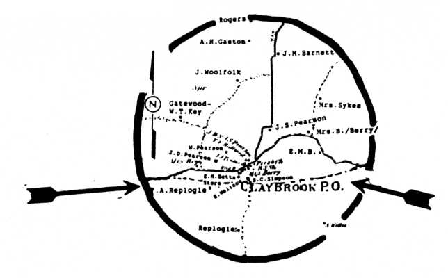
The Pearsons, along with other enterprising persons who bought land from them, established businesses and residences on the same, along the southern edge of the old Russell Goodrich tract, developed CLAYBROOK along Trace Creek in Civil District 12. The boundary line separating Civil Districts 12 and 13 ran as is shown in the D. G. Beers "Map of Madison County and Jackson, Tennessee, " in 1877:
(Page 9)
G. Madison County Deed Book 49, page 266
Partition of land between JONATHAN DUDLEY PEARSON and JOHN SOLOMON PEARSON, two tracts, 728 acres (reduced from the 744.5 acres purchased in 1865) and 374 acres (increase from 318 acres of 1865), some 1102 acres, each alloted some 551 acres. J. D. Pearson received the western half of the Pearson lands and John S. Pearson took the eastern half. August 27, 1891; recorded August 28, 1891. "Whereas by deed from R. W. Hall dated on the 21st day of Nov. 1865 and registered in the Register's office at Jackson on the 23rd day of Nov. 1865. And by will of our Father William Pearson decd. made on the 23rd day of April 1875 and probated in the County Court Clerk's office in Jackson at the Nov. term of said court 1878. We, J. D. and J. S. Pearson devised a title to and now hold equal undivided title and interest in and to a certain piece or parcel of land containing 728 acres more or less. Also one other tract containing 374 acres more or less, situated and lying in Madison County . . . /S.D. 9/ Range 2, Section 10 east of the meridian line."
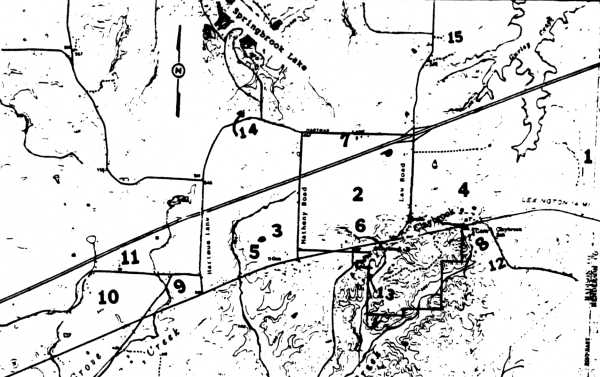
Shown on the topographical map (U.S. Geologic Survey) on page 10 are particular places of interest in the Liberty-Claybrook community. It is accompanied by a plat drawing of the Pearson 728 acres, drawn by James H. Hanna, Civil Engineer (Ret.), Jackson, Tennessee (July 1993); from the survey of 1891 and supplementary deeds. This is the remnant 728 acre tract of the original Goodrich 1000 acres. The original 1000 acres extended to the east of Law Road, shown on the topographical map — those portions owned at different times by Barnetts, Weirs, Doaks, Sykeses and Thomas F. Berry.
WILLIAM PEARSON (1810-1878) and his wife, ELIZA (WILLIAMS) PEARSON, lived in a log-house located in the central-southern section of the old Goodrich tract and his sons with their families lived on opposite sides of the tract — J. D. and Cornelia Pearson on the west; John S. and Martha Pearson on the east.
The three Pearson men sold a four-acre parcel along the south side of the Jackson-Lexington Road and a half-acre lot on a spring that fed into Trace Creek, in the crease of a hollow south of the four-acre parcel, January 1, 1868 to MARY L. (FOGG), wife of SAMUEL D. BARNETT, a veteran of the recent Civil War (Captain, Co. H, 51 Inf. Regt., CSA), a younger brother of John M. Barnett long a prominent farmer north of Claybrook; for $162.50.[2] With this purchase went the timber on the nearby "old" Keith place, except for the oak and chestnut trees fifteen or more inches in diameter, three feet from the ground. A right of way was also provided for a wagon lane, access to the mill site being projected from the main road. THE BARNETTS BUILT A FRAME HOUSE ON THE FOUR-ACRE PARCEL AND A STEAM SAW-GRIST-COTTON GIN ON THE HALF-ACRE LOT THAT SAME YEAR. THE MILL WAS KNOWN FOR MANY YEARS THEREAFTER AS THE CLAYBROOK MILL.
On December 13, 1869 the Barnetts sold to Evander M. Betts their new house and four acres on the main road and their steam mill and the timber on the nearby Keith place, for $2950. There were still large stands of fine virgin hardwood in this area.[3] The Betts family lived in Claybrook for years but E. M. "Vander" Betts sold a half-interest in the steam mill to the three Pearson men, father and sons, June 21, 1871, along with half of the timber on the former Keith farm.[4]
The Pearsons having gained full title to the Claybrook Mill, the father, William Pearson, sold it to Elizabeth, wife of S. C. Simpson, July 23, 1877.[5] The Simpsons owned and operated the cotton-saw-grist mill at this location for many years. Samuel Crawford Simpson (1829-1902), native of Tipton County, Tennessee, had served as a lieutenant in the 51 Tennessee Infantry Regiment, CSA, during the Civil War. He was married to Elizabeth L. Elmore
(continued on page 11.)
(Page 10)
Places Identified
1. Old Bethlehem Cumberland Presbyterian campground and church/cemetery site
2. Locale of the Russell Goodrich land grant, later divided into several farms, notably the Pearson farmsteads
3. Partial locale of the Joseph Phillips land grant, later divided into the Key, Hartmus and other farms
4. Former homeplace and farm of Thomas and Mary Berry
5. Key family graveyard
6. Pearson family graveyard, close to the former site of the William Pearson residence
7. Former homeplace and farm of John G. and Susan E. Woolfolk
8. Former site of the residence of Evander M. Betts, noted as "EMB" on the beers map, 1877; later site of Claybrook black schoolhouse
9. Locale of the former McCallum and Olive farms
10. Former homeplace and farm of David and Ida key
11. Former homeplace and farm of Martin B. and Mamie Key
12. Berry Zion Christian Methodist Episcopal church site
13. Former site of Pearson/Betts/S. C. Simpson cotton gin, saw mill and grist mill
14. Former site of the W. T. Key-Major Hartmus residence
15. Former site of the Burwell Butler residence and location of his family burial yard
[Note: The image above was cropped to fit on a screen without scrolling. In the book the map extends south to Cotton Grove, Liberty Road, and Liberty Church.
Click here for a 300 dpi image of the full map section.]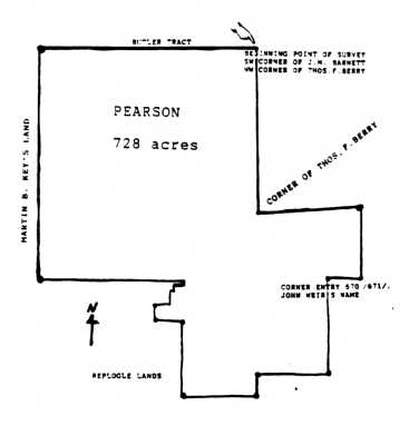
(Page 11)
(continued from page 9)
(1833-1885). They moved into Claybrook in 1877.[6]
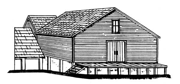
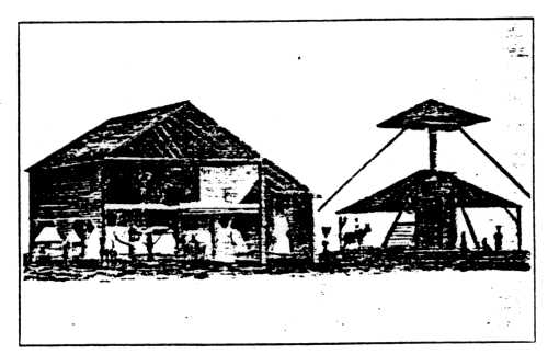
In June of 1901, S. C. Simpson agreed that since "I live with my son, Sam R. Simpson and he takes care of me" he would agree with this son and his other children, some of whom had already deeded their interest to their brother, to sell the mill and other nearby tracts to C. A. Tomlinson.[7] Eventually, several of the Pearsons bought all the Simpson land in and near Claybrook. The CLAYBROOK MILL — around 1900 — was drawn by Herschel K. Smith from an original snapshot of this establishment (kindly furnished the author by William W. and Ella Woolfolk of Spring Creek):
Cotton was the primary commercial crop of the Claybrook farming community. Planted in the spring, weeded and then "laid by" in the summer, actual cotton-picking might begin as early as September and continue well into the winter. It was back-breaking work, removing cotton from the boll hour after hour, dragging around/along heavy bags or baskets of this "white gold."
The illustration, shown here, from Harry Bates Brown's COTTON (New York, 1938), page 398, furnishes a good internal view of what the Claybrook Mill resembled.
"Before /and after/the Civil War, a gin house, with a screw press for baling cotton, was a familiar sight on nearly every large plantation in the South. The ginning was done during the winter or at times when there was no work to do in the fields. At such times there was plenty of labor available, both man and mule. . . . The seed cotton was carried to the gin by hand and fed into it by hand; the lint was carried from the gin to the press in baskets, emptied into the press box and tramped down by men. . . . Power to drive the gin and to turn the press screw was furnished by mules. Two mules were hitched to each of the large levers which were fastened to a big vertical wooden shaft. This shaft bore a large wooden cog wheel which engaged another wooden cog wheel on a horizontal shaft. A belt running from the horizontal shaft to the gin carried the motive power. When sufficient lint cotton had been packed in the press box by tramping to make a bale,
(Page 12)
pressure was applied by means of the large wooden screw above the box. The screw was raised and lowered by large levers to which mules were hitched. The bale was covered with jute or gunny sack and bound with two hemp ropes." A bale of cotton varied in weight, up to 500 pounds.[8] The cotton was then prepared for the market.
Years after the Claybrook Mill had ceased operation, Fred L. Exum, Sr. and partners, E. T. Blackmon and J. D. Hopper owned and operated a complete cotton gin establishment on the Jackson-Lexington Highway (State Highway 20). Examples of farm implements and household items found in the old Claybrook and other rural communities of the area may be seen in the WEST TENNESSEE AGRICULTURAL MUSEUM located on U.S. Highway 70A in Milan, Tennessee.
The Pearsons sold a lot to J. J. (Jack) Perdue in Claybrook, March 1875, at the northeast corner of the Betts property.[9] He sold this lot to J. H. Wallace, in July 1877 [10], who had a house and store located there but sold them through a trustee arrangement to W. R. Britt, son-in-law of E. M. Betts, December 13, 1886.[11] James C. "Jimmy" Pearson bought this place from the Britts, February 5, 1889.[12] (Perdue was a dry-goods merchant in Claybrook for years; he finally sold out there, 1.66 acres to J. C. Pearson, in March 1911.)
E. M. Betts had moved into the Claybrook community in 1869. Early in 1866 he had bought 175 acres about nine miles west of Jackson, including and excluding Andrew's Chapel (at Huntersville), paying $2275 in cash to Robert B. Hurt for this acreage.[13] He had resigned as constable of Civil District 14 in December 1865 and moved briefly into nearby Henderson County. This was about the time of his marriage to Lou Boswell of that county. In agreement with Samuel D. Barnett, he sold most of his Huntersville property (105 acres) in Civil District 7, to him, December 14, 1869, for $2500.[14] Betts, in turn, bought the house and lot in Claybrook and the steam mill from the Barnetts, for $2950 on the same day of the Barnett's purchase.[15]
Betts acquired the old Chamberlin homeplace, on the Jackson-Lexington Road and he and his family moved to this place and lived there for several years. He also bought a 159 acre tract, the old William B. Morrow farm, for $900 from A. J. Lewis in March 1872.[16] Then, on March 11, 1874, Betts deeded both these tracts to his wife, Eliza, including the Chamberlin place, "being the property upon which I now live," as he had spent the money that she had inherited from her father, Edward Boswell, on real property.[17] Some time before 1880 the Bettses had moved to the house, adjacent his storehouse, which he had bought from Sam Barnett.
E. M. Betts sold out to James C. Pearson, February 5, 1889, the house and store in Claybrook and a 50 acre tract besides, as he and family were moving to Lexington, Tennessee; for$2205.[18] "Jimmy" Pearson's family lived in the house near the store which he had continued for several years before moving into Jackson; in a few years he had moved back to this homeplace and kept the store too until his death in 1919. His widow sold her interest in his estate to his children soon afterwards (November 1919). His daughter, Beulah Dean Pearson Sneed, her husband, Earnest D. Sneed and their son, Kenneth D. Sneed, lived there for years; moved away to the Charley and Dean Key farm in 1947; a Johnson family bought the place then (the storehouse having already burned years before).[19]
CLAYBROOK, as a distinct entity dates to 1868, the year a post office was established there. It is not definitely known who suggested the name Claybrook or exactly why the name was chosen for the settlement. Its list of postmasters is given on page 13.
(Page 13)
CLAYBROOK POSTMASTERS
(Name of Postmaster and date of appointment)[20]
|
Frederick REPLOOLE |
June 2. 1866 |
|
Mail routed from Jackson to this community from August 10, 1910. |
|
CLAYBROOKE /sic/
More cotton has passed through Claybrooke en route for Jackson within the past two weeks than ever before known in the same length of time. Claybrooke is on the main road between this city and Lexington. Much of the cotton passing this village is from the Tennessee River country. Three years ago Claybrooke was without name and now it enjoys a fine say and grist mill, two stores, two blacksmith shops, one woodshop, a post office and a most flourishing school under the able management of Prof. W. F. Hinckle. In short, it is a rising village, backed by a rich and prosperous community of farmers. 'May its shadow never grow less.'
(WHIG-TRIBUNE, Jackson, December 20, 1873)
Exhibition at Claybrook
We regret our inability to be present at the exhibition of the Claybrook school on Thursday evening of last week, We were invited but it was impossible for us to be present. However, it is gratifying to us to learn, that the exhibition was a perfect success. The charades, dialogues, speeches and the music were all of high merit and Miss Scales who conducted the exercises deserves especial credit. The people around Claybrook are noted for industry, intelligence and public spirit. They have one of the best schools in the county and under Miss Scales management /of/ this school promises to achieve first-class renown as a preparatory institution of learning. We wish the people of Claybrook and their excellent school an abundance of prosperity and fame.
(THE JACKSON SUN, May 18, 1877)
"From Claybrook"
Messrs. Editors:
The pleasant little village of Claybrook is generally conceded to possess one characteristic which can not be said to be shared by most of similar hamlets of old Madison and that is immunity from chill and ague. The town is pleasantly situated on the slope of a range of hills, which environ it on every side, except the north. To the north are seen some of the best table lands of the county, not to be at all inviduous in distinctions — notable among these fine lands are the farms of J. D. Pearson, Esq. and his brother, J. S. Pearson and last, though by no means least, the beautiful farm of Mrs. Walter Key. There are three stores here, one of general merchandise kept by that wide-awake and worthy gentleman, E. M. Betts: two grocery stores by Dr. Walker and Mr. Wallace. One steam mill by M. Simpson and one blacksmith shop by Mr. Colleb /sic/. . . .
(TRIBUNE-SUN, Jackson, January 17, 1879)
CLAYBROOK
A settlement of 150 people in the eastern part of Madison county, 12 miles from Jackson and 170 from Nashville by railroad. The manufacturing and business interests comprise a steam flouring and saw mill, 2 carriage shops, 1 general store and 1 hotel. There is a Cumberland Presbyterian church and a male and female academy. Agricultural products. embracing wheat, cotton, flour, poultry and eggs are exported. Stage line to Jackson, the shipping point, and to the Tennessee river. Daily mail. Ersamus D. Sneed, postmaster.
BUSINESS DIRECTORY
Fincher & Stewens, wagonmakers
Hallford & Western, wagonmakers
Hinkle, W. F., principal academy
Sneed. E. D., Hotel, General Store, Saw and Flouring Mills.
From: TENNESSEE GAZETTEER AND BUSINESS DIRECTORY, 1876-1877 (Nashville. R. L. Polk Company, 1876), page 102
CLAYBROOK
Madison County
A village 12 miles northeast of Jackson, its nearest depot and express point and the county seat, via which it is 178 from Nashville. Population 270. Stages daily to Jackson and Lexington; fares $1. 00 and $l. 25. John L. Pearson, postmaster.
Betts, E. M. general store
Bird & Elkins, wagonmakers
Burnett,. N. R. H., carpenter
Ewell & Hughes, wagonmakers
Glenn, W. G., blacksmith (should be W. G. GREEN)
Grant, Prof. D. H., teacher
McGaughy, Rev. E. P. (C. Presbyterian)
Perdue, J. J., general store
Pearson Bros. General Store
Pearson, J. C., deputy-sheriff
Pearson, J. D., justice of peace
Pearson. W. T., grain and livestock
Simpmon. S. C., saw and grist mill
Williams, M. M., physician
From: TENNESSEE STATE GAZETTEER AND BUSINESS DIEECTORY, 1887 (Nashville, R. L. Polk Co., 1887), page 192
CLAYBROOK
MADISON COUNTY
A village, 12 miles northeast of Jackson, its nearest depot and express point and the county seat via which it is 178 from Nashville. Population, 270. Stages daily to Jackson and Lexington. J. C. Pearson, postmaster.
Black, Rev. N. R. (Cumb. Presbyterian)
Burnett, N. R. H, carpenter
Elkins, Lewis, blacksmith
Ewell & Kelsey, wagonmakers
Green, W. O., blacksmith
Jones, I. W., physician
Key, W. M., justice of peace
Perdue, J. J., general store
Pearson, D. H
Pearson, J. C. & W. L., general store
Simpson, S. C. & Sons, cotton gin, saw and grist mill
From: TENNESSEE STATE GAZETTEER AND BUSINESS DIRECTORY. 1890 (Nashville, R. L. Polk Co., 1891), page 194
(Page 14)
UNITED STATES CENSUS
Village of Claybrook
Madison County, Tennessee
June 14, 1880
Ferdinand Wood, Census Enumerator
/names, ages, relationships, vocation, place of birth of individual, place of birth of father, place of birth of mother/
|
PARDUE, |
, Jack, 48, drygoods merchant |
Tn |
NC |
Tn |
|
STEPHENS |
, Ligor, 28, wagon-maker |
NC |
NC |
NC |
|
SIMPSON |
, Sam, 50, miller |
Tn |
Va |
Ala |
|
BETTS |
, E. M., drygoods merchant |
Tn |
Tn |
Tn |
|
HODGSON |
, John, 26, blacksmith |
Eng |
Eng |
Eng |
|
TURNER |
, D. T., 37, wagon-maker |
Tn |
NC |
Tn |
|
ALEXANDER |
, Joe, 46, farm labor |
Tn |
Tn |
Tn |
Also living nearby, all in Civil District 12, were the families (among others) of Rufus Mayson (properly Mason), Liza Key and her daughter, Pattie Hartmus, John Woolfolk (pronounced WoolfoRk), J. D. Pearson, John S. Pearson, Milles /J. M./ Barnett. In Civil District 13, just to the south, ditto (among others): P. Replogle (male) and V. A. Replogle.
John Bingham received a land grant (#18797), March 10, 1823, for 348 acres in S.D. 9, R. 2, Sec. 10; entry #326 dated December 20, 1820; surveyed March 23, 1821. It began on the east boundary line of the Jonas Clark tract of 750 acres where it intersected the southern boundary line of Joseph Phillips 2500 acre tract.[21] He also received a land grant (#16742), March 9, 1822, for 442 acres in S.D. 9, R. 2, Sec. 10; entry #88 dated December 11, 1820; surveyed on March 23, 1821; this tract began at the northeast corner of said section 10.[22] 348 acres of the 442 acre grant was sold by the Binghams to Charles Chamberlin of Madison County for $493, April 2, 1825.[23]
Charles Chamberlin (sometimes Chamberlain) (1762-1850) was one of the earliest of the Claybrook area settlers. Besides the Bingham tract he also purchased other acreage so that he left a considerable estate to his heirs. In February of 1844, he placed in trust for his children, through Amos Williams, the 330 acres whereon he then lived, and slaves and cattle, being then aged 82, and his wife having "abandoned him the third time." He mentioned in this conveyance his son, George; daughter, Polly, wife of Reason Jones; son, Charles, Jr.; daughter, Elizabeth, wife of John L. Chamberlin (perhaps cousins?); grandson, C. W., son of dec'd. son, William; daughter, Patsy, wife of Alexander Muns; and the legal heirs of dec'd. son, Thomas.[24] The old man died in 1850. /25
Colonel Abel Willis (October 12, 1776-October 2, 1873) was another early settler. His plantation lay to the southwest of Claybrook.[26] Colonel Willis lived well and affluently for many years. He left a 370 acre landholding to the children of his daughters, Jane Wood and Nancy Hord.[27]
(Page 15)
Several members of the Weir family were early farmfolk, with lands near the Henderson County line. An aged matron, Ann Weir, left her estate to a son, Hugh Weir, at her death in 1842.[28] She probably lies buried with other members of her family in the Bethlehem burial ground. Hugh Weir died in 1845.[29] The old Bethlehem Campground was on or near his property. He had a small land grant, 7 acres, at the southeast corner of John Weir's 120 acre entry, in S.D. 9, R. 2, Sec. 10; entered February 6, 1823; surveyed April 9, 1823; issued as grant, September 10, 1823.[30]
Robert Rogers was another early and active member of the Bethlehem Cumberland Presbyterian congregation. His land lay nearby and mostly in Henderson County. He had two land grants, one for 50 acres and another for 4 acres, in that county, S.D. 9, R. 3, Sec. 10; both dated 1827. His land lay adjoining John Weir's land.[31]. In the tax list for Henderson County, Civil District 1, for the year 1836, Robert Rogers was listed with 165 acres, valued at $1155; one slave. A neighbor, Jane Weir, was listed with 100 acres, valued at $600. Ed Boswell, whose daughter, Eliza, would later marry E. M. Betts, was listed in the same district with 100 acres, valued at $600.[32] Robert Rogers lies buried in the Bethlehem burial ground.
The Howlett family lived near the Weirs and Barnetts. Elizabeth (Ramsey) Howlett-, widow of Isaac Howlett who had died in Davidson County, Tennessee about 1832, came into Madison County several years later, where she died in the spring of 1844.[33] The older of her children, Green C. Howlett, born about 1812, bought 95 acres from Hugh M. Weir, for $450, in Civil District 12, December 20, 1842.[34] He had married earlier that year, September 15, to Virginia Harp. He died in 1851, directing in his LWT that his property be kept intact for the benefit of his children, Joseph and Ellen Howlett and his sister-in-law, Jackey Harp (who would later marry John M. Barnett).[35] His brother, William R. Howlett, born in 1819, lived later in Jackson; a brother, Isaac Howlett died young; two sisters, Mary D. and Susan A. Howlett, lived in this community for years.[36]
[Page 16 includes references for Early Settlement and Early and Later Roads]
(Page 17)
REFERENCES
l. Weston A. Goodspeed, HISTORY OF TENNESSEE, Henderson County (Nashville, 1887), pages 848-849. Information in article about Joseph N. Hall, son of R. W. Hall.
2. Madison Co.: deed book 25, page 583. Deed recorded March 20, 1868.
3. IBID.: deed book 27, page 349. Deed recorded December 14, 1869.
4. IBID.: deed book 29, page 82. Deed recorded July 5, 1871.
5. IBID.: deed book 35, page 36. Deed recorded July 23, 1877.
6. Weston A. Goodspeed, HISTORY OF TENNESSEE, Madison County (Nashville, 1887), page 903. Samuel C. Simpson."
7. Madison Co.: deed book 62, page 436. Deed filed January 2O, 1903. See, also, deed book 56, page 513, for other Simpson heirs sale of this property to Sam R. Simpson.
8. COTTON, by Harry B. Brown (New York, 1938), page 398-399.
9. Madison Co.: deed book 35, page 444. Deed recorded February 2, 1878.
10. IBID.: deed book 35, page 445. Deed recorded February 2, 1878.
11. IBID.: deed book 43, page 488. Deed recorded December 14, 1886.
12. IBID.: deed book 47, page 384. Deed recorded January 1, 1890.
13. IBID.: deed book 24, page 372. Deed recorded October 24, 1866. Betts sold the remainder of this acreage in January 1868. Deed book 25, page 444.
14. IBID.: deed book 27, page 350. Deed recorded December 14, 1869.
15. IBID.: deed book 27, page 349. Deed recorded December 14, 1869.
16. IBID.: deed book 30, page 147. Deed recorded May 27, 1872.
17. IBID.: deed book 32, page 89. Deed recorded March 11, 1874.
18. IBID.: deed book 47, page 621. Deed recorded March 26, 1890.
19. IBID.: deed book 94, page 66. Deed recorded November 22, 1919. Conversation with Kenneth D. Sneed, August 6, 1993.
20. TENNESSEE POST OFFICES AND POSTMASTER APPOINTMENTS, 1789-1984, by D. R. Frazier, page 535.
21. TSLA, Nashville: General Land Grant Book X, page 104. Recorded Oct. 17, 1823.
22. IBID.: 2, page 835. Recorded April 23, 1822.
23. Madison Co.: deed book 1, page 584. Deed recorded July 19, 1827.
24. IBID.: deed book 9, page 253. Deed recorded April 2, 1844.
25. IBID.: county court minute book 6, page 277. LWT, Charles Chamberlin, proven Feb. 1851; noted that he had died in 1850.
26. See, Madison County deed book 6, page 574 for location of Willis plantation.
27. Madison Co.: will book A, page 181. LWT, Abel Willis, executed October 24, 1867, with 1870 codicil; proven November 4, 1873.
28. IBID.: will book 3, page 626. LWT, Ann Weir, executed August 1, 1842; proven November 11, 1842.
29. IBID.: county court minute book 5. On November 6, 1845 James Weir was granted letters of administration on Hugh Weir's estate.
30. TSLA, Nashville: General Land Grant Book W, page 552.
31. IBID.: West Tennessee Land Grant Book 1, pages 353 and 425. He bought 34 acres, over the border in Madison County, part of the Isaac Swan grant, adjoining John Weir. (Deed book 2, page 136)
32. TSLA, Nashville: Tax lists of Henderson County, Tenn., 1836-1837.
(Page 18)
33 . Weston A. Goodspeed, HISTORY OF TENNESSEE, Madison County (Nashville, 1887), page 875. "William R. Howlett."
34. Madison Co.: deed book 8, page 460. Deed recorded in December 1842.
35. IBID.: will book 5, page 91. LWT, Greerl C. Howlett, executed Feb. 1, 1851; proven June 1851 with John M. Barnett as executor.
36. IBID.: county court minute book 5, pages 42, 141, 271, 444, 493, 505, 539.
Return to Contents