|
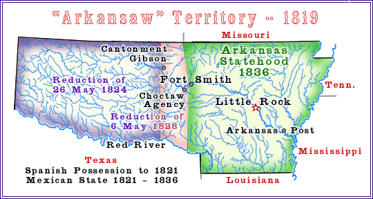
Arkansas Territory
1819-1836
The Spanish had on 30 November 1803 transferred to France a vast tract
of land later to be known as the Louisiana Purchase. Just twenty days
later, France transferred the same tract to the United States. To the
south and west and of this tract lay the lands of New Spain. It was not
until 22 February 1819 that the United States and Spain came to an
understanding regarding the boundaries.
Less than five months later, Congress created the Arkansas (Arkansaw)
Territory. The new territory ran southwards and westwards to the new
Spanish-U.S. treaty line. The territory was twice reduced (1824 and 1828)
leaving the eastern portion to become the state of Arkansas in 1836.
The severed western portion of the original Arkansas Territory became
include in the area so named “Indian Country” by the U.S.
Congress in 1834. This area came to hold the Cherokee, Chickasaw, Choctaw,
Creek, and Seminole Nations and in time came to be part of the later
so called Indian Territory. Some of the 1890 Oklahoma Territory came from
the Arkansas Territory and in 1907, the old Indian Territory and the
Oklahoma Territory joined to become the State of Oklahoma.
The first capital of Arkansas was a small but very old town (founded
1686) on the Arkansas River named “Arkansas Post. ” This
town usually appears on early maps simply as “Post. ” The
capital was transferred in 1820 to Little Rock.
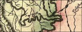
Post Arkansas : Map : John Melish, 1816 : LoC
Treaty with Spain, 22 February 1819
Arkansaw Territory, 5 July 1819
“Part of the Missouri territory after July 4, 1819, to form a separate
territory to be called Arkansaw.”
STATUTE II
March 2, 1819
CHAP. XLIX.--An Act establishing a separate territorial government in the
southern part of the territory of Missouri. (a)
Be it enacted by the Senate and House of Representatives of the United States
of America, in Congress assembled, That from and after the fourth day of
July next, all that part of the territory of Missouri which lies South of a
line, beginning on the Mississippi river, at thirty-six degrees, north latitude,
running thence west to the river St. Francois; thence, up the same, to
thirty-six degrees thirty minutes north latitude ; and thence, west to the
western territorial boundary line; shall, for the purposes of a territorial
government, constitute a separate territory, and be called the Arkansaw territory ...
****
Statutes at Large:
Fifteenth Congress Sess. II, CH 40 1819 (excerpt pp. 493-4)
****
Reduced, 26 May 1824
“Course of the western boundary line of the territory of
Arkansas.”
STATUTE I.
May 26, 1824.
CHAP. CLV,--An Act to fix the western boundary line of the territory of
Arkansas, and or other purposes. (a)
Be it enacted by the Senate and House of Representatives of the United
States of America, in Congress assembled, That the western boundary line
of the territory of Arkansas shall begin at a point forty miles west of the
south-west corner of the state of Missouri, and run south to the right bank
of the Red River, and thence, down the river, and with the Mexican boundary,
to the line of the state of Louisiana, any law heretofore made to the contrary
notwithstanding …
****
Statutes at Large:
Eighteenth Congress Sess. I, CH 155 1824 (excerpt p. 40)
****
Reduced, 6 May 1828
Treaty with the Western Cherokee, May 6, 1828.
ART. 1. The Western boundary of Arkansas shall be,
and the same is, hereby defined, viz: A line shall be
run, commencing on Red River, at the point where the
Eastern Choctaw line strikes said River, and run due
North with said line to the River Arkansas, thence in
a direct line to the South West corner of Missouri ...
****
Indian Affairs: Laws and Treaties.
Vol. II (Treaties) in part. Compiled and edited by Charles J. Kappler.
Washington : Government Printing Office, 1904. (excerpt p. 288)
****
Indian country established, 30 June 1834
“Indian Country annexed, for legal purposes, to the district of Missouri,
&c.”
CHAP. CLXI,--An act to regulate trade and intercourse with the Indian tribes, and to
preserve peace on the frontiers.
...
Sec. 24. And be it further enacted, That for the sole purpose of carrying
this act into effect, all that part of the Indian country west of the
Mississippi river, that is bounded north by the north line of lands
assigned to the Osage tribe of Indians, produced east to the state of
Missouri: west, by the Mexican possessions; south, by Red river; and east,
by the west line of the territory of Arkansas and the state of Missouri,
shall be, and hereby is, annexed to the territory of Arkansas; and that
for the purpose aforesaid, the residue of the Indian country west of the
said Mississippi river shall be, and hereby is, annexed to the judicial
district of Missouri; and for the purpose aforesaid, the several portions
of Indian country east of the said Mississippi river, shall be, and are
hereby, severally annexed to the territory in which they are situate ...
****
Statutes at Large:
Twenty-third Congress Sess. I, CH 161 1834 (excerpt p. 733)
****
Arkansas Statehood, 15 June
1836.
Arkansas admitted into the Union; Boundaries
STATUTE I.
June 15, 1836.
CHAP. C,--An Act for the admission of the State of Arkansas into
the Union, and to provide for the due execution of the laws of the
United States, within the same, and for other purposes.
Whereas, the people of the Territory of Arkansas, did, on the thirtieth
day of January in the present year by a convention of delegates, called
and assembled for that purpose, form for themselves a constitution and
State Government, which constitution and State Government, so formed,
is republican: and whereas, the number of inhabitants within the said
Territory exceeds forty-seven thousand seven hundred persons, computed
according to the rule prescribed by the constitution of the United
States; and the said convention have, in their behalf, asked the
Congress of the United States to admit the said Territory into the
Union as a State, on an equal footing with the original States:
Be it enacted, by the Senate and House of Representatives of the
United States of America in Congress assembled, That the State of Arkansas
shall be one, and is hereby declared to be one of the United States of America,
and admitted into the Union on an equal footing with the original States,
in all respects whatever, and the said State shall consist of all the
territory included within the following boundaries, to wit: beginning
in the middle of the main channel of the Mississippi river, on the
parallel of thirty-six degrees north latitude, running from thence
west, with the said parallel of latitude, to the Saint Francis river;
thence up the middle of the main channel of said river to the parallel
of thirty-six degrees thirty minutes north; from thence west to the
southwest corner of the State of Missouri; and
from thence to be bounded
on the west, to the north bank of Red river, by the lines described in the
first article of the treaty between the United States and the Cherokee
nation of Indians west of the Mississippi, made and concluded at the city
of Washington, on the 26th day of May, in the year of our Lord one thousand
eight hundred and twenty-eight; and to be bounded on the south side of Red
river by the Mexican boundary line, to the northwest corner of the State of
Louisiana; thence east with the Louisiana State line, to the middle of the
main channel of the Mississippi river; thence up the middle of the main
channel of the said river, to the thirty-sixth degree of north latitude,
the point of beginning ...
****
Statutes at Large:
Twenty-fourth Congress Sess. I, CH 100 1836 (excerpt pp. 50-51)
(Also see Act of June 23, 1836, ch. 120, page 58)
****
|
|