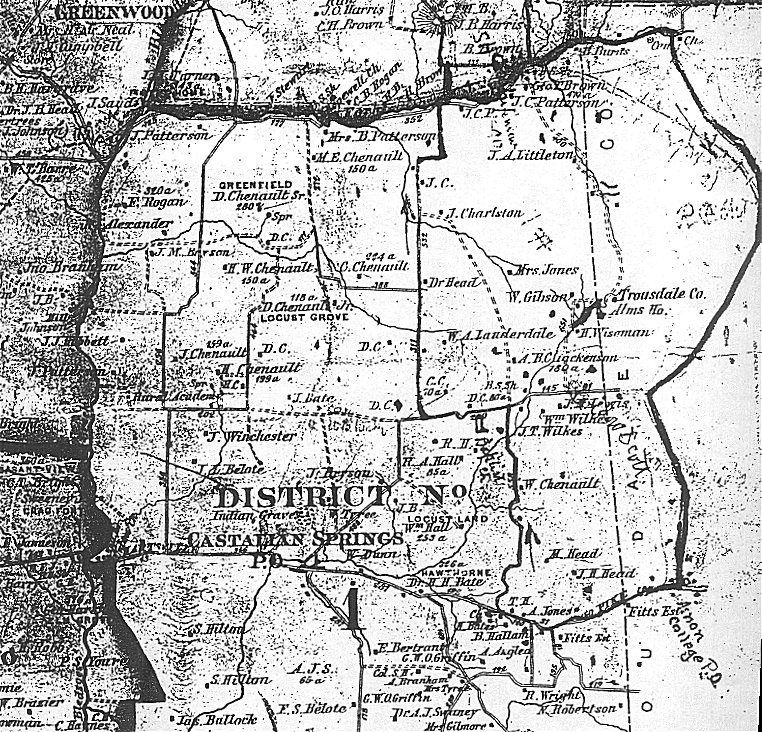
1878 Sumner County, TN Map
District 1
Available for copying at the Sumner County Archives and the Tennessee State Library and Archives
Transcribed and submitted by Joyce Stark Blocker, Linda Carpenter,
Eileen McCarey, Diane Payne, & Danene Vincent
© September 1999
 |
| Last Name | First Name | Location | Comments |
| Alexander | R. | 1 | |
| Anglea | A. | 1 | |
| Anglea | M. | 1 | |
| B. | J. | 1 | |
| B. | M. | 1 | |
| Basquett | A. | 1 | |
| Bate | H. H., Dr | 1 | Hawthorne, 326 acres |
| Bate | J. | 1 | |
| Bate | M. | 1 | |
| Bates | H. | 1 | |
| Belote | F. S. | 1 | |
| Belote | J. L. | 1 | |
| Bentley | B. | 1 | |
| Bentley | J. | 1 | |
| Bentley | M., Mrs | 1 | |
| Bentley | P. | 1 | |
| Bentley | S. | 1 | |
| Bertrant | E. | 1 | |
| Bettis | E. | 1 | |
| Bigger | 1 | ||
| Branham | A. | 1 | |
| Brown | Geo T. | 1 | 470 acres |
| Bryson | J. | 1 | |
| Bryson | J. M. | 1 | |
| Bullock | G. | 1 | |
| Bullock | Jas | 1 | |
| Burns | R. | 1 | |
| C. | C. | 1 | 70 acres |
| C. | D. | 1 | |
| C. | D. | 1 | |
| C. | D. | 1 | 80 acres |
| C. | E. P. | 1 | |
| C. | H. | 1 | |
| C. | J. | 1 | |
| Caldwell | E. P. | 1 | |
| Charlston | J. | 1 | |
| Chenault | C. | 1 | 224 acres |
| Chenault | D., Jr. | 1 | Locust Grove, 118 acres |
| Chenault | D., Sr. | 1 | Greenfield, 280 acres |
| Chenault | H. | 1 | 199 acres |
| Chenault | H. W. | 1 | 150 acres |
| Chenault | J. | 1 | 159 acres |
| Chenault | M. E. | 1 | 150 acres |
| Chenault | W. | 1 | |
| Corum | A. | 1 | |
| Corum | H. C. | 1 | |
| Corum | W. | 1 | |
| Corum | W. | 1 | |
| Cox | E. | 1 | |
| Dickenson | A. B. C. | 1 | 180 acres |
| Dickerson | W. | 1 | |
| Drake | B. | 1 | |
| Dunn | W. | 1 | |
| Fitts | 1 | ||
| Fitts | 1 | Estate | |
| Gibson | W. | 1 | |
| Gilmore | Mrs. | 1 | |
| Griffin | G. W. O. | 1 | |
| H. | R. | 1 | |
| H. | T. | 1 | |
| Hall | R. A. | 1 | 85 acres |
| Hall | Wm. | 1 | Locust Land, 253 acres |
| Hallam | B. | 1 | |
| Hamilton | H. | 1 | |
| Hamilton | J. | 1 | |
| Hamilton | M. P. | 1 | |
| Harrison | N or B. | 1 | |
| Harrison | N. S. | 1 | |
| Head | Dr. | 1 | |
| Head | J. H. | 1 | |
| Head | M. | 1 | |
| Hibbett | J. J. | 1 | |
| Hilton | S. | 1 | |
| Hilton | S. | 1 | |
| Hopson | H. | 1 | |
| Jones | A. | 1 | |
| Jones | Mrs. | 1 | |
| Lauderdale | W. A. | 1 | |
| Lewis | J. M. | 1 | |
| Littleton | J. A. | 1 | |
| Lockett | H. G. | 1 | |
| Loving | S. | 1 | |
| M. | E. | 1 | |
| McMurray | 1 | ||
| Mills | S. | 1 | |
| Mitchener | E. N. | 1 | |
| Mitchener | J. N. | 1 | |
| Morris | E. | 1 | |
| P. | J. C. | 1 | |
| Patterson | B., Mrs | 1 | |
| Patterson | J. | 1 | |
| Patterson | J. | 1 | |
| Patterson | J. C. | 1 | |
| R. | J. D. | 1 | |
| Ramsey | D. | 1 | |
| Ramsey | R. | 1 | |
| Ridley | Goe | 1 | |
| Robertson | C. | 1 | |
| Robertson | J. O. | 1 | |
| Robertson | N. | 1 | |
| Rogan | F. | 1 | 320 acres |
| S. | A. J. | 1 | 65 acres |
| Sanders | W. | 1 | |
| Stone | J. C. | 1 | |
| Swaney | A. J., Dr. | 1 | |
| Swaney | B. P. | 1 | |
| Sweeney | 1 | ||
| Swett | J. | 1 | |
| Thomas | H. G. L. | 1 | Estate |
| Tolliver | W. | 1 | |
| Tyree | Mrs. | 1 | |
| Tyree | W. | 1 | |
| Walker | M. | 1 | |
| Wiley | H. | 1 | |
| Wilkes | J. T. | 1 | |
| Wilkes | S. | 1 | |
| Wilkes | S. M. | 1 | |
| Wilkes | U. | 1 | |
| Wilkes | Wm. | 1 | |
| Williams | S. | 1 | |
| Winchester | J. | 1 | |
| Wiseman | H. | 1 | |
| Wright | R. | 1 | |
| Wright | R. | 1 | |
| Y. | T. P. | 1 | |
| Young | G. W. | 1 | |
| Young | J. R. | 1 | |
| Youree | B. | 1 | |
| Youree | D. | 1 | |
| Youree | R? | 1 | |
| Youree | T. P. | 1 |
| Place Name | Location |
| B. S. Sh. (Blacksmith Shop) | 1 |
| Bapt. Ch (Baptist Church) | 1 |
| Belote's Ferry | 1 |
| Bledsoes Cr. (Creek) | 1 |
| Canoe Branch | 1 |
| Canoe Branch Ferry | 1 |
| Cem. (Cemetery) | 1 |
| Ch. (Church) | 1 |
| Col. S. H. (Colored School House) | 1 |
| Cumberland River | 1 |
| East Fork (of Bledsoe's Creek) | 1 |
| Greenfield | 1 |
| Hartsville Pike | 1 |
| Hawthorne | 1 |
| Locust Grove | 1 |
| Locust Land | 1 |
| Mill | 1 |
| Proposed Cumberland and Ohio Railroad | 1 |
| Rural Acad.. (Rural Academy) | 1 |
| S. H. (School House) | 1 |
| Spr. (Spring) | 1 |
| Toll Ho. (Toll House) | 1 |
| Trousdale Co. Alms Ho. (Alms House) | 1 |
| Union Church | 1 |
| Warehouse | 1 |
View the 1878 District 1 North map
View the 1878 District 1 South map
You MUST use your BACK key to return to this screen.
Return to 1878 Sumner County Map Page
Return to Sumner County Main Page
 |