1895 Rand-McNally Map
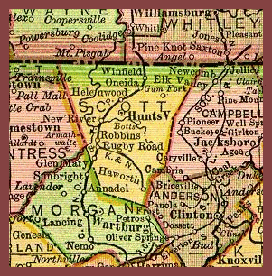
This cutout of Scott County is from an atlas originally printed and copywritten in 1895 by the Rand McNally Corporation, called "The New 11 x 14 Atlas of the World". Although it contained maps of the countries of the world and the individual states of the United States at that time, it only contained an index for the United States. Maps from this atlas depicting the United States are online and can be reached at the 1895 U.S. Atlas. Thanks to Pam Rietsch for making the Atlas available.
![]()
![]()


![]() This page was
created by Timothy N.
West and is copyrighted by him.
All rights reserved.
This page was
created by Timothy N.
West and is copyrighted by him.
All rights reserved.