OUR CLAYBROOK HERITAGE
(Madison County, Tennessee)
By Jonathan K. T. Smith
Copyright, Jonathan K. T. Smith, 1993.
EARLY AND LATER ROADS
(Page 4)
It was essential to have passable roads laid through this virgin territory. The county court was responsible for providing the actual routing of these roads but the men living where these roads ran were
(Page 5)
obliged by law to help maintain them.
On November 8, 1825 the court ordered on petition from the citizenry, that Abel Willis, Daniel Barcroft, John Hardgrove, Burrell Butler, among a few others, to serve as a jury of view "to mark" a road leading from the county line near Daniel Berrycroft (Barcroft) so as to intersect the Reynoldsburg Road at the most convenient point and report back to the next term of court. The Reynoldsburg Road was the principal stage road through this vicinity.[1]
The jury of view (that worked like a committee) performed its assigned duty and made a report to the county court, February 6, 1826, whereupon the road leading "from the end of Dan'l. Berrycroft's lane on the county line to the Reynoldsburgh Road between the Widow Wilson's old place and Col. /Abel/ Willis be received /accepted/." Thomas Vincent served as overseer of this road with local men charged with maintaining the travelway.[2]
BETHLEHEM CAMPGROUND lay on the boundary line between Madison and Henderson counties in northeastern Madison County. A road lead east from Jackson passing NEAR the Bethlehem Church and its burial ground. An alteration of convenience in the routing of this road was permitted by the court's order dated December 28, 1824 in the "road passing the graveyard on the road leading from Jackson by John Weir /pronounced as wear/."[3] John Weir's homeplace was 13.5 miles northeast of Jackson on the main road from that county seat to Reynoldsburg on the Tennessee River.[4]
The earliest road through the Claybrook vicinity worthy of the name may have been that ordered marked out, leading from the county seat of Madison County — Jackson — to that of Henderson County — Lexington, in June of 1822; later that year designated as a first-class road.[5] However, it was only in January of 1830 that regular stage mail service began, from Nashville to Memphis, routed over these early. roads, taking three and a half days each way. Jackson was a main stage "Stop" on this long route.[6]
In a map of Madison County drawn by Keeton M. Jones and Ezekial B. Mason, the surveyors who mapped the county's borders in this instance, dated their map November 26, 1842. In the description accompanying this map was that part which dealt with northeastern Madison County; it read:[7]
BEGINNING. The survey starts at the extreme northeast corner of Madison County and runs south some 25 miles, denoting the eastern boundary of said county, two and one half miles north of the corner of the 10 section on a large red oak marked MCCH, the north east corner of said county and the most southern south east corner of Carroll on the vest boundary line of Henderson County runs south with said line and the 2 range line, crossing a road third class at 240 poles continuing south crossing another road at the one mile & 16 poles a small creek at one mile & 102 p /poles/ at a beach marked MCL 1842 the Lexington and Jackson road at 2 miles passing the corners of sections 10 & 11 at 2 miles & 160 poles a small creek at 3 miles 280 poles by the way of Independence passing Bethlehem Campground at 5 miles, continuing south by the way of R. /Robert/ Rogers crossing the stage road at 6 miles & 20 poles crossing the road leading to independence at 6 M /miles/ 110 poles, crossed a small creek at 8 miles and at various distances & on south crossing the Jackson and Lexington road by way of B. Ballard at 11 miles & 208 poles
The rolling and hilly uplands in northeastern Madison County were and remain well-drained, an active loaming soil, well-suited to row crops such as hay and pasture. Some of the most "generous", fertile soil found in West Tennessee is to be found in the Clay-brook area, the best f arm-land being what later generations have called the Memphis silt loam.[8] Land speculators, forerunners of zealous real estate brokers, sent their agents into this fine agricultural region in the early days of settlement, "grabbing up" the best farming tracts to be sold for hefty profits.
The 1877 Beers "Map of Madison County" shows clearly that the local
(Page 6)
road leading north to South, into Claybrook itself, at that time and evidently for many years previously, took a direct western turn at John S. Pearson's homeplace, then turned southward, opening on the Jackson-Lexington Road somewhat west of its present juncture with this old road's 1931 successor. Sometime in the 1880s this road was altered so that it ran exactly along the west boundary line between the Pearson and Berry tracts or what is now LAW ROAD.
|
|
|
"PLAN AND PROFILE OF PROPOSED STATE HIGHWAY FEDERAL PROJECT NO. 235 from State Route 1 to Henderson County line (8.278 miles) — Now St Highway 20 and U.S. 412. Approved by the State Commissioner of High and Public Works, June 1930 and completed February 9, 1931. Sullivan, and Hagerty, Bessemer, Alabama, road builders, responsible for grading bridging and hard-surfacing of this highway. |
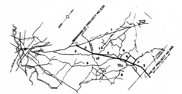
PLACES LOCATED BY NUMBER ON THE ROAD PLAN ABOVE
1. United States Highway 70/Tennessee Highway 1 as it has been routed since 1931
2. In BOLD and dark line, Tennessee Highway 20 (Jackson to Lexington highway)
3. Brown's Church Road, a "stretch" of the Jackson to Lexington highway prior to 1931
4.Upper Brown's Church Road, a "stretch" of the Jackson to Lexington highway prior to 1931; a gravel road now terminating in its junction with Hartmus Lane
5.Hartmus Lane
6. Matheny Road
7. Law Road
8. Liberty-Claybrook Road
9. Cotton Grove Road, one of the primary antebellum roads of Madison County
10. McLeary Road
11. Libery Road
12. Spain Road
(Page 16)
REFERENCES
1. Madison Co.: county court minute book 2, page 3.
2. IBID., page 28.
3. IBID.: minute book 1, page 421.
4. JACKSON GAZETTE, January 29, 1825.
5. Madison Co.: county court minute book 1, page 27.
6. JACKSON GAZETTE, January 16, 1830.
7. Madison Co.: county court minute book 5, page 161.
8. "Soil Survey of Madison County, Tennessee," prepared by the U. S. Dept. of Agriculture, Soil Conservation Services and Tennessee Agricultural Experiment Station, 1978, pages 12 and 16 and "General Soil Map."
Return to Contents