Henderson Co. TN
Mr. Jonathan Kennon Thompson Smith of Jackson has published seven genealogical miscellanies for Henderson County. He wishes to share this information as widely as possible and has granted permission for these web pages to be created. We thank Mr. Smith for his generosity. Copyright, Jonathan K. T. Smith, 2001
Previous to 1836 the quarterly court of Henderson County, consisting of magistrates elected in captains' districts (defined by individual militia captains) conducted the business of the county (schools, roads, taxes, probate of wills and deeds, etc.). For generations the basic internal governmental structure of Henderson County and its sister counties in Tennessee consisted of CIVIL DISTRICTS from each of which two justices of the peace, or magistrates, except for the district in which the county seat was situated had three justices, who constituted the county's quarterly court (meeting quarterly through the year) that conducted the business affairs that were the responsibility of this court in connection with other county officials. To be a justice of the peace, a "J.P." was prestigious and some individuals developed political "fiefdoms" in their districts. People generally were identified in numerous instances by the civil districts in which they resided.
The 1835 Constitution of Tennessee created the organizational existence of the civil districts while commissioners actually laid off the county into these districts and designated the polling places within each. In the Tennessee State Library and Archives, in the manuscript collection, is a rough map prepared by the 1836 commissioners, dated January 1 of that year in which the boundaries of the first original fifteen civil districts were laid out. With the thoughtful permission of James H. Hanna, civil engineer, a neat copy of this 1836 map with the general locations of these districts, certain roads and places, which he has drawn, is reproduced . . .[below]. This is done to implement the research into the development of the civil districts made by the present writer. In April 1842 the magistrates created Civil District 16 from parts of districts 14 (south of Beech River), 11 and 13. In January 1843 the magistrates created Civil District 17 from parts of districts 8, 9, 10; in that same month they also created Civil District 18 from district 15 (northern portion), as shown in documents drawn up by JESSE TAYLOR, county court clerk. These districts are also located generally on the Hanna map. Sometime in the 1850s (due to the burned county court minutes the precise dates are not ascertained) the county court created two additional civil districts, the 19th district west of Lexington and the 20th district south of Lexington.
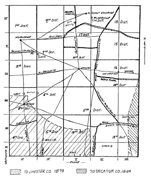
On January 1, 1846 the state legislature created Decatur County, a portion of which was detached from the southeastern section of Henderson County (ACTS OF TENNESSEE, 1845-1846, Chapter 62, pages 123-124) which area is shaded on the Hanna map. An even larger portion of Henderson County, in its south, was detached, much of districts 3, 4, 5 and 12 and added to the northern portion of Chester County created March 4, 1879 (IBID.,1879, Chapter 42, pages 59-63). This area too is shaded on the Hanna map. At this time considerable "juggling" was done by the magistrates to realign the boundaries of its districts so as to retain twenty civil districts for the county.
The civil districts were maintained in Henderson County with these same boundaries for a generation but on April 11, 1903, through the state legislature, the county underwent a major restructuring of its civil districts: "districts 1, 8, 9 and 17 were designated as CIVIL DISTRICT ONE; districts 2, 7 and 19 were designated as CIVIL DISTRICT TWO; districts 3, 4, 11 and 20 were designated as CIVIL DISTRICT THREE; districts 12 and 13 were designated as CIVIL DISTRICT FOUR; districts 5, 6 and 10 were designated as CIVIL DISTRICT FIVE; districts 14, 15, 16 and 18 were designated as CIVIL DISTRICT SIX; effective December 31,1903.(ACTS OF TENNESSEE, 1903, Chapter 243, pages 555-557) On April 13, 1905 the legislature, through pressure from some of the citizenry in the lower southeastern section of the county, set apart portions of new districts 3, 4 and 6 to form CIVIL DISTRICT SEVEN. At the same time a portion of new district two north of the Lexington-Jackson road, running through Juno, was added to district one(IBID., 1905, Chapter 399, page 827).
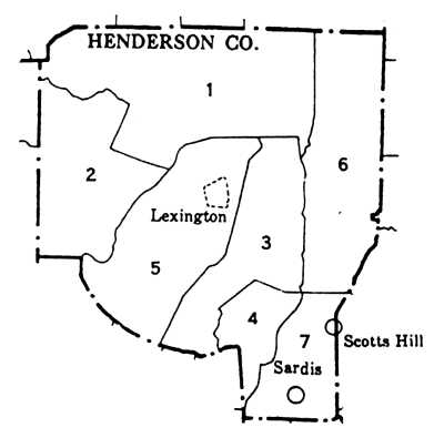
Down through the years the magistrates would occasionally permit, in answering petitions, very small sections of the civil districts to be taken from one district and added to another adjoining one. The legislature would occasionally permit a resident or residents of Henderson County adjoining another county to become a resident of that county by placing his land within it and vice versa. The 1950 map, reproduced . . . [above], drawn for the U.S. Census Bureau, shows bounds of the civil districts for many years.
With constitutional reform in March 1978 the county courts of the state became boards of commissioners, representing commissioner districts, thereby eradicating the old quarterly court and its magistrates. The new district lines were altered a few times since then, the latest realignment dating from 1991, a map delineating the new boundaries being on display in the office of the Henderson County Election Commission. Roughly described, commissioner district one consists of much of northern and western Henderson County; commissioner district two consists of much of southwestern Henderson County; commissioner district three falls in eastern Henderson County; commissioner district four falls to the southwest of Lexington; commissioner district five falls to the southeast of district four; commissioner district six falls within the general area of Lexington; the commissioner district seven falls to the panhandle of the county in the area of Scots Hill and Sardis.
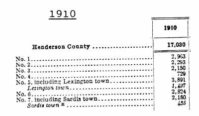
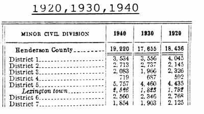
The official populations of Henderson County, as defined by the U.S. Bureau of the Census, have been:
1830: 7,315 whites, 1,433 blacks
1840: total of 11,875 blacks/whites
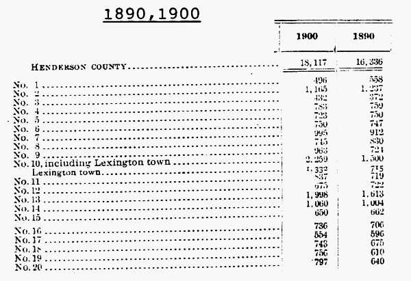
1950: 17,173
1960: 16,115
1970: 17,360
1980: 21,390
1990: 21,844
volume I · volume II · volume III · volume IV · volume V · volume VI · volume VII