The
These Ocoee District Land Grants presented to you by:
David Johnson,
&
Joyce Gaston Reece, Polk and
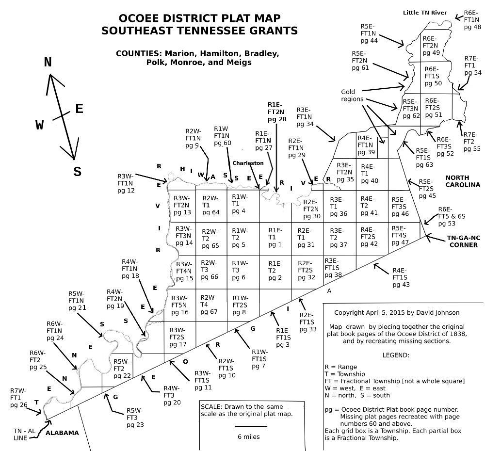
The map being presented to you on this website is taken directly from the microfilm of the original plat maps. They will differentiate slightly from maps you may have previously seen or used. These plat maps will give you, the user, the most accurate information as originally presented & corrected by the editor.
Below you will see a link to land grant certificates for Book B. As time progresses all the Ocoee Grant grant certificates will be presented via these pages. In the meantime if you have the location of the land with a Range and township number you can use the links below to see the plat maps and search for your ancestor.
Map created by David Johnson, used with permission.
Please read.
In 1835, a prominent Cherokee leader, The Ridge (Major John) and a small,
unofficial, party of Cherokee signed a document that became know as the 1835
Cherokee Removal Treaty. The Ridge
Party who negotiated this treaty did so without the approval of Principal Chief
John Ross or his council who did everything possible to nullify this
treaty…unsuccessfully. Since Andrew
Jackson and some congressional leadership wanted the Indians removed, they used
this treaty, illegally, to make it happen.
Andrew Jackson was known as an Indian fighter his entire career.
He obviously held animosity toward any Native American group….the
Seminole, Creek, Catawba, Chickasaw, Lumbee, Yammassee, Euchi and hundreds of
others were all removed from their ancestral homes.
This particular treaty ceded all remaining land of the Cherokee Indians
east of the
Having given the Nation three years to move west, the final removal, per
the treaty, was in 1838. This
portion of the Removal is the specific ‘Trail of Tears’…being the portion in
which the remaining citizens were forced from their homes to immigrate to
These ceded lands in
The state of
THE GOLD LOTS:
When the Hiwassee Purchase grants were allotted beginning in 1820, much
of the mountainous area of what is now eastern
The area includes lands in Polk and Monroe including
4 3 2 1
5 6 7 8
12 11 10 9
13 14 15 16
This allocation was decreed by the State
of
THE POLK
Please note on this map in the north-eastern portion of
THE IRON ACT:
Also enacted was the Iron Act which was supposed to encourage the production of iron ore in the area. This act was a bit useless since there were several businesses of the type already established by the machinations of Cherokee Agent, Return Jonathan Meigs.
UNASSIGNED LAND:
When studying these grants one will notice that much of the land was
listed as being granted to men like William Wetmore, Luke Lea and Pleasant J.R.
Edwards. For the most part this was
the land in the
LAND DEEDS AND THEIR RELATIONSHIP TO THESE MAPS & GRANTS:
Soon after the grants were allocated, the county’s were formed then reformed so some deeds will be deceptive. It is better to locate the land by using the original Ocoee District Map and the information on the grant. Here’s why. After the counties began laying off their tax districts fractional townships were eliminated and townships often re-numbered. The description given in deeds will often depend on WHEN the deed was issued. It wasn’t a great number of years until these land descriptions weren’t used at all. Therefore it is best to use these original maps when attempting to locate granted land.
This information is for those residents who lived in the land area that was
The county line of
QUESTIONABLE DEBACAL:
On August 3, 1839, 40 tracts of land of 160 acres each was entered for
the
In line with the standard practices that come down from the Northwest Ordinance system, section #16 of each township was to be reserved for land to create schools. Six-hundred and forty acre tracts was set aside for the usage of the schools
A quote from The History of Polk County by respected historian Mr. Roy G. Lillard.
“County School Lands were provided for by
the Northwest Ordinance of 1789.
The history of common school land of Polk County began with the Act of the
A total of 6,400 acres was allotted for school land in the Ocoee District Each 16th section was to be designated as school land & a full slate of “640 acres per township” was the standard allotment or ten sections.
THE CHEROKEE RESERVATIONS:
The land being held by Cherokee citizens as a result of the 1817 & 1819
Reservation Treaties had little effect on the land grants.
All four states (
One of the best genealogical tools we have is being able to know exactly where our ancestors may have lived, how they lived and who their neighbors were. Understanding this map and locating your ancestor is the purpose of this section. YOU will need to read and understand the information below before attempting to locate any tract of land.
THE BASE (
This map is based on a ‘grid’ system.
In 1817 to 1820 the Hiwassee Purchase and its accompanying map was the
first time this type map had been used in the
RANGES:
Range lines were topographically every SIX miles, east or west and placed numerically. West of the base line was RANGES 1 -7 numbered from east to west. East of the base line the RANGES were numbered 1-7 numbered from west to east (beginning at the base line).
TOWNSHIPS:
Here we must define Fractional Townships as opposed to Townships. When these maps were originally done they were created with some townships being fractional or less than the complete townships of 36 square miles.
Thirty-six sections equaled one township.
SECTIONS:
You will please note there are 36 SECTIONS placed as follows:
6 5 4 3 2 1
7 8 9 10 11 12
18 17 16 15 14 13
19 20 21 22 23 24
30 29 28 27 26 25
31 32 33 34 35 36
In each section is 640 acres (a square mile) which were divided up into
four areas….Northeast (NE), northwest (NW), southeast(SE) & southwest (SW).
These were the QUARTER SECTIONS.
Each quarter section was 160 acres.
Quarter sections were often subdivided into 40 or 80 acres.
CORNERS were smaller sections within each quarter section and listed as
the, for example, south east corner of the
In the instances in which the land lay in a FRACTIONAL TOWNSHIP is where we see the exceptions to the above rule. These would have been in the townships where the above full 36 square miles did not exist….along rivers, state lines, Indian boundaries or other occurrences. In these cases you will see odd numbers of acreage being allotted. Full SECTIONS in FRACTIONAL TOWNSHIPS were handled the same as noted above.
Some users may have the info from a well used book on many shelves in
libraries “Abstracts of
The TRACTS of land were assigned a number with the date always given.
So when reading a grant you will see (an example) R1E - FT1S #1 - SWcSEq
Translated this is Range one, East of the Base line, located in fractional township one, south, in the southwest corner of the Southeast quarter. It was 40 acres.
Another example is this:
R1E T1 #7 SWcSWq
Range one, west of the base line, in township one, section #7, Southeast corner, South west quarter section.
To determine where the townships are one must refer back to the map. (Please note that she has incorrectly labeled the townships in Range 3 West as they deviate from the original assigned township numbers. There could be other errors as well.)
OTHER INFORMATION:
As stated earlier each tract of land was assigned a tract number, Also given is the name, acreage, type of grant, location, date and amount paid.
TYPES:
OE – Occupant Enterer
GE - General Enterer
TRE – Transferred
AOE – Assignee of Occupant Enterer
OTHER IMPORTANT INFORMATION:
The map being presented to you on this website is taken directly from the microfilm of the original plat maps. They will differentiate slightly from maps you may have previously seen or used in the past. These plat maps will give you, the user, the most accurate information as originally presented.
Range 3 WEST had 5 fractional townships north and two south but the Registrar in making out the grants always called “Range 3W FT2S” as “Range 3W T6”. The plat book has that Township as FT2S not FT6. You are being linked to the correct place if looking at tracts in Range 3. That is the surveyors official layout in the plat. There are several grants that gave another wrong township because the township named on the grant did not exist by that name. Of the many errors by the Register, only the R3W T6 error was every time. There were many other Register errors, and were researched on the plat maps and the right location found. The township numbers was incorrect.
There were also 8 plat pages missing from the plat book images on microfilm. Found were many grants in Book B on all of the townships. For those townships with no plat pages, these have been reconstructed or will be reconstructed as we get information from the grant pages.
This is a corrected version of the original. New plat pages are in progress. If there is disagreement between the plat book and the grant, the plat is what is chosen as correct. In most cases the Register did not know his north from his south and ignored the correct name for things in writing the grant.
The grants do not give the selling price per acre. On the plat book pages the price per acre cost is given. In PDF form (Google Books) for "Land Laws of Tennessee" tells that an occupant has first rights to buy the land for a number of months after the grants start. After two months, anyone can claim it and buy it. After a second two months, it is again reserved to the occupant if nobody else bought it and it is reserved to him for two months. Cycle over and over again. Each 4 month period the price per acre dropped by this plan until it hit 1 cent or perhaps 1/2 cent per acre.
Once you have located a name you wish to view please click on the link below which will take you to the Marion County site where these certificates now reside.
http://tngenweb.org/marion/archive/deeds/Ocoee_B.html
or
Follow the ARCHIVES link to DEEDS then Ocoee Land Grants
(Images of Book B Grant Certificates coming soon)
The following links go directly to the original plat pages as taken from microfilm. They will be difficult to read. The files are deliberately left large so you can download them and make them large enough to read easier on your computer.
T - Township
FT - Fractional Township
S - South
N - North
E - East
W - West
Ranges are numerical 1-7 west & 7 - 1 East
RANGES WEST
RANGES EAST